
Murray River facts for kids
Quick facts for kids Murray River(Millewa / Dhungala (Tongala)) |
|
|---|---|
The course of the Murray River (click to enlarge)
|
|
| Country | Australia |
| State | New South Wales, South Australia and Victoria |
| Cities | Albury, Wodonga, Echuca, Swan Hill, Mildura, Renmark, Murray Bridge |
| Physical characteristics | |
| Main source | Cowombat Flat Australian Alps, NSW 1,430 m (4,690 ft) 36°47′46″S 148°11′40″E / 36.79611°S 148.19444°E |
| River mouth | Murray Mouth near Goolwa South 0 m (0 ft) 35°33′32″S 138°52′48″E / 35.55889°S 138.88000°E |
| Length | 2,508 km (1,558 mi) |
| Depth |
|
| Basin features | |
| Basin size | 1,061,469 km2 (409,835 sq mi) |
| Tributaries | |
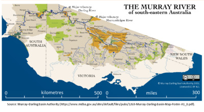
The Murray River is a very important river in Southeastern Australia. It is Australia's longest river, stretching for 2,508 km (1,558 mi). Many other long rivers in Australia flow into the Murray. These include the Murrumbidgee, Darling, Lachlan, Warrego, and Paroo Rivers.
All these rivers together form the Murray–Darling basin. This huge area covers about one-seventh of Australia. It is known as Australia's most important region for farming that uses irrigation (watering crops).
The Murray River starts in the Australian Alps, which are Australia's highest mountains. It flows northwest across Australia's flat inland areas. The river forms the border between New South Wales and Victoria. Then it flows into South Australia. Near a town called Morgan, the river turns south for its last 315 km (196 mi). It reaches Lake Alexandrina, where the water can be salty. The water then flows through small channels around Hindmarsh Island and Mundoo Island. It joins water from The Coorong before flowing into the Great Australian Bight (also called the Southern Ocean) through the Murray Mouth. This mouth is 10 km (6.2 mi) east of Goolwa South. Even though a lot of water flows out, the Murray Mouth is usually slow and shallow.
Around 2010, the Murray River system received about 58 percent of its natural water flow. This amount can change a lot. The border between Victoria and New South Wales is along the top of the southern bank of the Murray River.
Contents
About the Murray River


The Murray River is part of the 3,750 km (2,330 mi) long Murray-Darling river system. This system drains most of inland Victoria, New South Wales, and southern Queensland. The Murray carries less water than similar-sized rivers in other parts of the world. Its water flow also changes a lot each year.
The river has completely dried up three times during very bad droughts since records began. More often, a sandbar forms at the mouth, stopping the water flow. The Murray River forms the border between New South Wales and Victoria. This border is specifically at the top of the river bank on the Victorian side.
For 11 km (6.8 mi) west of the 141°E longitude line, the border is in the middle of the river. This is between Victoria and South Australia. West of this section, the Murray River is entirely within South Australia.
Towns Along the River
Many towns are located along the Murray River. Here are some major ones, listed from the river's start to its end at the ocean. The populations are from the 2016 Australian census.
| Town | Population | Data source |
|---|---|---|
| Albury-Wodonga | 89,007 | |
| Yarrawonga–Mulwala | 9,810 | |
| Echuca–Moama | 18,526 | |
| Swan Hill | 10,905 | |
| Mildura and Merbein | 35,451 | |
| Renmark–Paringa | 9,475 | |
| Berri | 4,088 | |
| Loxton | 4,568 | |
| Waikerie | 1,632 | |
| Mannum | 1,632 | |
| Murray Bridge | 16,804 | |
River Life and Environment
The Murray River and its smaller rivers (tributaries) are home to many kinds of river life. These animals have adapted to the river's changing conditions. Native fish include the famous Murray cod, trout cod, golden perch, and eel-tailed catfish. Other water animals are the Murray short-necked turtle, yabbies (a type of freshwater crayfish), and Macrobrachium shrimp. You can also find common long-necked turtles, platypus, and water rats. The Murray crayfish is an endangered species, but its numbers have grown thanks to scientists.
The river also has many river red gum trees along its banks. The health of the Murray has gotten much worse since Europeans settled in Australia. This is mainly because people have changed the river's natural flow. Very bad droughts between 2000 and 2007 caused a lot of stress for the river red gum forests. This made people worry about their future.
The Murray has also flooded sometimes. The biggest flood was in 1956. It lasted up to six months and covered many towns in South Australia.
Ancient History of the Murray
Lake Bungunnia
Between 2.5 and 0.5 million years ago, the Murray River ended in a huge freshwater lake. This lake was called Lake Bungunnia. It formed when earth movements blocked the river near Swan Reach. At its largest, Lake Bungunnia covered 33,000 km2 (12,741 sq mi). It stretched almost to the Menindee Lakes in the north.
The lake drained about 600,000 years ago. Thick clay from the lake can still be seen in cliffs around Chowilla in South Australia. Much more rain would have been needed to keep such a large lake full. When Lake Bungunnia drained, it seems to have marked the end of a wet period. After this, the Murray–Darling Basin became dry, much like it is today. A type of Australian lungfish used to live in Lake Bungunnia. Today, these lungfish are only found in some rivers in Queensland.
Cadell Fault and Red Gum Forests
The famous Barmah River red gum forests exist because of something called the Cadell Fault. About 25,000 years ago, the ground moved along this fault. This raised the eastern side of the fault by 8 to 12 m (26 to 39 ft). This caused many changes to the river.
Part of the original Murray River channel was left empty. Today, this is known as Green Gully. The Goulburn River was blocked by the fault, creating a natural lake. The Murray River then flowed north around the Cadell Fault. This created the Edward River channel, where much of the Murray's water still flows.
Later, the natural dam on the Goulburn River broke. The lake drained, and the Murray River changed its path to the south. It started flowing through the smaller Goulburn River channel. This created "The Barmah Choke" and "The Narrows," where the river is unusually narrow. After this, it joined the main Murray River channel again.
The Cadell Fault causes the Murray River's westward flowing water to hit the fault. This makes the water split and flow both north and south around the fault. It flows through the Edward River and the old Goulburn River channels. This regularly floods a large area of low land. These conditions are perfect for River Red Gums, which quickly formed forests there. So, the Cadell Fault directly led to the famous Barmah River Red Gum Forests.
The Barmah Choke and The Narrows limit how much water can flow down this part of the Murray. During floods or when a lot of water is released for irrigation, most of the water flows through the Edward River channel. The Murray River has not had enough power to naturally widen The Barmah Choke and The Narrows.

Murray Mouth

The Murray Mouth is where the Murray River meets the sea. The currents here are shallow, shifting, and change a lot. This makes the area complex and hard to predict. When paddle steamers were common (from about 1855 to 1920), the mouth made it very difficult to move goods between Adelaide and the Murray towns. Many ships sank or were wrecked there.
Since the early 2000s, special dredging machines have worked at the Murray Mouth 24 hours a day. They move sand from the channel to keep a small flow of seawater coming in. This water goes into the Coorong's lagoon system. Without this dredging, the mouth would fill with sand and close. This would stop fresh seawater from entering the Coorong National Park, causing the water to get warm, still, and harm the ecosystem.
Aboriginal Mythology
The Murray River is one of the biggest river systems on Earth's driest continent. It is very important to Aboriginal Australians. The Ngarrindjeri people of Lake Alexandrina believe the Murray was created by the Great Ancestor, Ngurunderi. He was chasing Pondi, the Murray Cod.
The chase started in New South Wales. Ngurunderi chased the fish on rafts made from red gums. He kept throwing spears at Pondi. But Pondi was clever and swam in a winding path, creating the river's different smaller rivers (tributaries). Ngurunderi had to land his rafts and often make new ones as he moved along the river.
At Kobathatang, Ngurunderi finally hit Pondi in the tail with a spear. The fish was so shocked that it shot forward in a straight line to Peindjalang, near Tailem Bend. Ngurunderi and his two wives hurried on. They waited high on the cliff where Tailem Bend is now, hoping to catch Pondi. But they failed again. Ngurunderi chased Pondi again but lost him when Pondi dived into Lake Alexandrina.
Ngurunderi and the women settled on the shore. However, they had bad luck fishing because of a water monster called Muldjewangk. They later moved to a better spot where Ashville is today. The two peaks of Mount Misery are said to be what's left of Ngurunderi's rafts. They are known as Lalangengall, meaning "the two watercraft."
This story of a hunter chasing a Murray cod that created the river is told in many ways by different Aboriginal groups. These groups live in the huge area covered by the Murray River system. For example, the Wotojobaluk people of Victoria tell of Totyerguil from the area now called Swan Hill. He ran out of spears while chasing Otchtout the cod.
European History
Early Explorers
The first Europeans to see the Murray River were Hamilton Hume and William Hovell. They crossed the river where Albury is now in 1824. Hume named it the Hume River after his father.
In 1830, Captain Charles Sturt reached the river. He had traveled down its smaller river, the Murrumbidgee River. Sturt named it the Murray River to honor Sir George Murray, who was a British government official. Sturt did not know it was the same river Hume and Hovell had seen earlier. Sturt continued down the Murray to Lake Alexandrina and the river's mouth. Captain Collet Barker explored the area around the Murray Mouth more closely in 1831.
River Transport


Ships cannot enter the Murray from the sea because it does not have a deep estuary. However, in the 1800s, the river was used for a lot of trade. Shallow paddle steamers carried goods. The first trips were made by two boats from South Australia in 1853. The Lady Augusta reached Swan Hill, and the Mary Ann reached Moama (near Echuca). By 1855, a steamer carrying gold-mining supplies reached Albury. Echuca was usually the main stopping point.
When the railway reached Echuca in 1864, most of the wool from the Riverina area was sent by river to Echuca. From there, it went south to Melbourne by train. The river had many "snags," which were fallen trees hidden underwater. These were dangerous for ships. A lot of effort was made to remove them. Today, some dead gum trees are put back into the river. This helps create homes for fish that lost their breeding grounds.
River transport started to decline when railways reached many points along the Murray. The river's water levels were not always reliable. This made it hard for boats to compete with trains and later, road transport. However, the river is still used for fun today. Small private boats are used for water skiing and fishing. Houseboats are also common for rent or private use. Many old paddle steamers and newer boats offer cruises. These can last from half an hour to five days.
River Crossings
The Murray River has always been a big obstacle for land travel and trade. Many towns that were ports for river transport also became places to cross the river. People could cross by bridge or ferry. The first bridge across the Murray was built in 1869 in the town of Murray Bridge. It was first called Edwards Crossing. This bridge is known as Murray River road bridge, Murray Bridge. People had to pay tolls on South Australian ferries until November 1961.
Water Management

Small pumps started taking water from the Murray in the 1850s. The first large pumping station was built at Mildura in 1887. These pumping stations helped farming grow and led to the creation of irrigation areas. Irrigation means watering crops using water from the river.
In 1915, the three states that share the Murray – New South Wales, Victoria, and South Australia – signed the River Murray Agreement. This agreement planned to build large storage areas (reservoirs) at the river's source. They also planned to build them at Lake Victoria near the South Australian border. Along the river, a series of locks and weirs were built. These were first meant to help boats travel even when water was low. But river transport was already decreasing because of better roads and railways.
Changing the river's natural flow, water running off from farms, and new animal species like the European carp have caused serious harm to the river. Many people worry that the river will become too salty in the future. This is a big problem because the Murray supplies 40 percent of the water for Adelaide. Efforts to fix these problems are ongoing. However, different groups often disagree, which slows down progress.
New fish species like carp, gambusia, and redfin perch have also badly affected native fish. Carp are especially harmful. They have damaged the Murray and its smaller rivers by destroying water plants and making the water permanently cloudy. Carp are the most common fish in all parts of the river.
Reservoirs and Dams
Four large reservoirs (artificial lakes) were built along the Murray. These are:
- Lake Victoria (finished in the late 1920s)
- Lake Hume near Albury-Wodonga (finished 1936)
- Lake Mulwala at Yarrawonga (finished 1939)
- Lake Dartmouth, which is on the Mitta Mitta River (finished 1979)
The Murray also gets water from the large dam and pipeline system of the Snowy Mountains Scheme. Another reservoir was planned in the 1960s at Chowilla Dam in South Australia. But it was canceled because of high costs and worries about increased saltiness. Instead, Dartmouth Dam was built.
Barrages
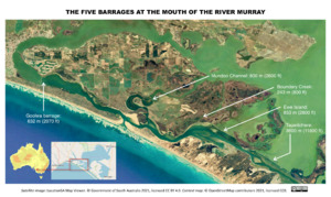

From 1935 to 1940, a series of barrages (low dams) were built near the Murray Mouth. Their purpose was to stop seawater from entering the lower river when the water flow was low. These barrages include:
- Goolwa Barrage (632 metres (2,073 ft))
- Mundoo Channel Barrage (800 metres (2,600 ft))
- Boundary Creek Barrage (243 metres (797 ft))
- Ewe Island Barrage (853 metres (2,799 ft))
- Tauwitchere Barrage (3.6 kilometres (2.2 mi))
These dams changed the river's natural flow. Originally, there were floods in winter-spring and dry periods in summer-autumn. Now, the water level is low in winter and higher in summer. These changes made sure there was enough water for irrigation. This made the Murray Valley Australia's most productive farming area. However, these changes have also seriously harmed many natural environments in and around the river. The irrigation has also led to dryland salinity, which now threatens farming.

Locks
Lock 1 was finished near Blanchetown in 1922. Torrumbarry weir started working in December 1923. Out of many locks that were planned, only thirteen were built. These are Locks 1 to 11 downstream of Mildura, Lock 15 at Euston, and Lock 26 at Torrumbarry. Building the other weirs just for navigation was stopped in 1934. The last lock, Lock 15, was finished in 1937.
Lock 11, just downstream of Mildura, creates a 100-kilometre (62 mi) long pool of water. This helped with irrigation pumping from Mildura and Red Cliffs. Each lock has a path next to it through the weir. This path is opened when the river flow is high, and there is too much water for the lock. The weirs can be completely removed, and the locks can be fully covered by water during floods.
| Name | No. | River Distance* | Elevation** | Com- pleted |
|---|---|---|---|---|
| Blanchetown | 1 | 274 km (170 mi) | 3.3 m (10.8 ft) | 1922 |
| Waikerie | 2 | 362 km (225 mi) | 6.1 m (20.0 ft) | 1928 |
| Overland Corner | 3 | 431 km (268 mi) | 9.8 m (32.2 ft) | 1925 |
| Bookpurnong | 4 | 516 km (321 mi) | 13.2 m (43.3 ft) | 1929 |
| Renmark | 5 | 562 km (349 mi) | 16.3 m (53.5 ft) | 1927 |
| Murtho | 6 | 620 km (385 mi) | 19.2 m (63.0 ft) | 1930 |
| Rufus River | 7 | 697 km (433 mi) | 22.1 m (72.5 ft) | 1934 |
| Wangumma | 8 | 726 km (451 mi) | 24.6 m (80.7 ft) | 1935 |
| Kulnine | 9 | 765 km (475 mi) | 27.4 m (89.9 ft) | 1926 |
| Wentworth | 10 | 825 km (513 mi) | 30.8 m (101 ft) | 1929 |
| Mildura | 11 | 878 km (546 mi) | 34.4 m (113 ft) | 1927 |
| Euston | 15 | 1110 km (690 mi) | 47.6 m (156 ft) | 1937 |
| Torrumbarry | 26 | 1638 km (1020 mi) | 86.05 m (280 ft) | 1924 |
| Yarrawonga Weir | n/a | 1992 km (1238 mi) | 124.9 m (410 ft) | 1939 |
| * Distance is from the Murray Mouth. ** Elevation is above sea level, at full supply level (i.e., maximum capacity). |
||||
Images for kids
-

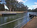
Lock 1 and weir at Blanchetown
-
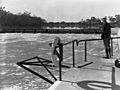
Lock 5 at Renmark, about 1935
-
Lock 11, Mildura

_(cropped).jpg)

See also
 In Spanish: Río Murray para niños Major Rivers that Flow into the Murray
Towns and Cities on the Murray
- Albury-Wodonga
- Echuca
- Swan Hill
- Mildura
- Renmark
- Murray Bridge
- Goolwa South
