Mitta Mitta River facts for kids
Quick facts for kids Mitta Mitta |
|
|---|---|

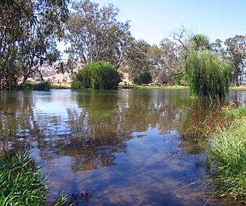
Mitta Mitta River, downstream from Dartmouth Dam, 2007
|
|
| Native name | Mida-modoenga |
| Country | Australia |
| State | Victoria |
| Region | Australian Alps (IBRA), Victorian Alps |
| Local government area | Towong |
| Physical characteristics | |
| River mouth | confluence with the Murray River Mitta Junction, Lake Hume 180 m (590 ft) 36°07′1″S 147°2′30″E / 36.11694°S 147.04167°E |
| Length | 204 km (127 mi) |
| Basin features | |
| River system | North-East Murray catchment, Murray-Darling basin |
| Basin size | 10,062 km2 (3,885 sq mi) |
| Tributaries |
|
| Reservoirs |
|
The Mitta Mitta River is a river in Victoria, Australia. It's a "perennial" river, which means it flows all year round! It's also a direct tributary (a smaller river that flows into a larger one) of the mighty Murray River. The Mitta Mitta River is an important part of the huge Murray-Darling Basin, which is a massive area of land drained by the Murray and Darling rivers and their tributaries.
The name "Mitta Mitta" comes from an Aboriginal word, mida-modoenga. This word means "reeds called modunga," which are a type of plant.
Contents
River's Journey
The Mitta Mitta River starts high up in the Victorian Alps, below Mount Bogong. This is the tallest mountain in the area! The river officially begins where two other rivers, the Cobungra River and the Big River, meet near a place called Anglers Rest.
From there, the Mitta Mitta River flows generally north. Along its journey, it's joined by twenty-four smaller streams, including the Dart River. Finally, it reaches its mouth where it joins the Murray River at Lake Hume, east of Albury. The river travels about 204 km (127 mi) and drops about 514 m (1,686 ft) in height from its source to its mouth.
River Flow and Dams
The Mitta Mitta River is very important because it provides about 40% of the water that flows into the Murray River. The amount of water in the Mitta Mitta can actually triple from the southern part (Hinnomunjie) to the northern part (Tallangatta). The most water flows in October, which is when the snow from the mountains melts in spring.
The river's flow is greatly controlled by two large dams: Dartmouth Dam and Hume Dam. These dams are major water reservoirs. Upstream from Dartmouth Dam, the river flows quickly through beautiful, untouched forests. Below the dam, it moves more slowly through flatter, cleared farmland. The original spot where the Mitta Mitta River met the Murray River is now often underwater because of Lake Hume.
The area of land that drains water into the Mitta Mitta River is about 10,062 km2 (3,885 sq mi). Before the Dartmouth Dam was finished in the 1970s, the river valley used to flood almost every year. The dam helped stop these floods.
Towns Along the River
The Mitta Mitta River flows through a beautiful valley. You can find four small towns along its path: Mitta Mitta, Eskdale, and Dartmouth. The town of Mitta Mitta is a small village located where the river meets Snowy Creek.
Fun Activities
The Mitta Mitta River is a great place for outdoor fun!
Fishing
If you love to fish, the Mitta Mitta River is known for its trout. You can often catch brown trout and sometimes even rainbow trout here.
White Water Adventures
For those who enjoy exciting white water sports, the Mitta Mitta River upstream of Hinnomunjie Bridge is a popular spot. Some companies offer guided trips for white water rafting. Many people also enjoy kayaking on the river for a single day or a multi-day adventure. The river has sections with different difficulty levels, from easy (Grade II) to more challenging (Grade IV).
 | Audre Lorde |
 | John Berry Meachum |
 | Ferdinand Lee Barnett |


