Big River (Mitta Mitta River, Victoria) facts for kids
Quick facts for kids Big |
|
|---|---|

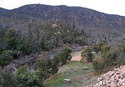
Looking south over the Big River at the Bundara Campground, near Anglers Rest
|
|
| Country | Australia |
| State | Victoria |
| Region | Victorian Alps (IBRA), East Gippsland |
| Local government area | East Gippsland Shire |
| Physical characteristics | |
| Main source | Spion Kopje, Victorian Alps near Falls Creek 1,850 m (6,070 ft) 36°49′S 147°19′E / 36.817°S 147.317°E |
| River mouth | confluence with the Cobungra River to form the Mitta Mitta River Anglers Rest 645 m (2,116 ft) 36°59′23″S 147°30′40″E / 36.98972°S 147.51111°E |
| Length | 52 km (32 mi) |
| Basin features | |
| River system | North-East Murray catchment, Murray-Darling basin |
| Tributaries |
|
| National park | Alpine National Park |
The Big River is a river in Victoria, Australia. It's a perennial river, which means it flows all year round. It's an important part of the huge Murray-Darling Basin.
This river starts high up in the Australian Alps, near Falls Creek. It then flows into the Cobungra River near a place called Anglers Rest. When these two rivers meet, they form the Mitta Mitta River.
Where Does the Big River Flow?
The Big River begins below the ski resort at Falls Creek. This area is part of the beautiful Alpine National Park. It starts on the northern slopes of a peak called Spion Kopje.
The river flows north at first. Then it turns east, running through a valley. This valley is between Spion Kopje and Mount Bogong, which is Victoria's highest mountain. The river then turns south-southeast. It forms the eastern edge of the national park.
Near the Omeo Highway, the river turns south. This is about 16 kilometres (9.9 mi) north of Anglers Rest. The Omeo Highway follows the river closely for a while.
The Bundara River joins the Big River about 2 kilometres (1.2 mi) north of Anglers Rest. Soon after this, near Anglers Rest, the Big River meets the Cobungra River. Together, they become the Mitta Mitta River. The Big River drops about 1,210 metres (3,970 ft) over its 52-kilometre (32 mi) journey.
Smaller Rivers Joining the Big River
Many smaller streams flow into the Big River. These are called its tributaries. Some of the main ones include Cairn Creek, Beckraith Creek, Camp Creek, and Hollonds Creek. Others are Dead Horse Creek, Middle Creek, Glen Wills Creek, Wallaby Creek, Burnside Creek, and the Bundara River.
These smaller rivers come from different mountain slopes. They flow from the northern slopes of Spion Kopje and the southern slopes of Mount Bogong. They also come from Mount Nelse, Mount Cope, Mount Wills, and The Knocker.
How Healthy is the River?
Most of the rivers and streams in this area are in good condition. Large forests cover much of the land around the river. Even though some land has been cleared and farm animals can damage river banks, the river's natural environment is generally very good.
The upper part of the Big River is special. It's known as a "Representative River of East Victorian dissected uplands." This means it's a good example of a healthy river in this type of landscape.
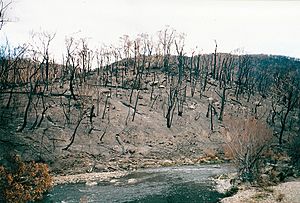
In 2003, big bushfires affected the area. The 2003 Eastern Victorian alpine bushfires burned about 13,000 square kilometres (5,000 sq mi) of bushland for almost two months. This fire damage affected the health of the river for some time afterward.
 | James Van Der Zee |
 | Alma Thomas |
 | Ellis Wilson |
 | Margaret Taylor-Burroughs |


