
Mount Bogong facts for kids
Quick facts for kids Mount Bogong |
|
|---|---|
| Warkwoolowler, Bugung | |

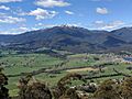
The western flank of Mount Bogong
|
|
| Highest point | |
| Elevation | 1,986 metres (6,516 ft) AHD |
| Prominence | 1,233 metres (4,045 ft) AHD |
| Geography | |

Mount Bogong
Location in Victoria
|
|
| Location | Alpine National Park, Victoria, Australia |
| Parent range | Victorian Alps, Great Dividing Range |
| Climbing | |
| First ascent | 1854 – Baron Sir Ferdinand von Mueller (by a European) |
| Easiest route | Staircase Spur |


Mount Bogong is the highest mountain in Victoria, Australia. It stands at 1,986 metres (6,516 ft) (about 6,516 feet) above sea level. This amazing mountain is part of the Victorian Alps and the larger Great Dividing Range. You can find it inside the beautiful Alpine National Park.
Mount Bogong is very tall, rising more than 1,600 metres (5,200 ft) (about 5,250 feet) from the nearby town of Mount Beauty to its top. This makes it one of Australia's highest peaks, not just by how high it is above the ocean, but also by how much it rises from its base. The Big River separates Mount Bogong from the Bogong High Plains to the south.
This mountain is a popular spot for backcountry skiing in winter. It usually has snow during the middle of winter and spring. It's about 30 kilometres (19 mi) (18.6 miles) by road and walking track from Mount Beauty. Other ski areas like Falls Creek and Mount Hotham are also close by. Camping is safer below the treeline, but the very top of the mountain is very open and exposed to the weather.
There are also emergency shelters available on the mountain. These include Bivouac Hut on the Staircase Spur, Cleve Cole Hut, and Michell's Hut on the Eskdale Spur. These huts offer a safe place to rest in bad weather.
Contents
What's in a Name? Mount Bogong's Meaning
The name Bogong comes from the local Aboriginal languages. In the Waywurru and Dhudhuroa languages, the mountain is called Warkwoolowler. This name means "the mountain where Aboriginal people collected the boo.gong fly". The word Bugung in the Dhudhuroa language means "the brown moth," which refers to the Bogong moth (Agrotis infusa). Some people also believe that "Bogong" in the local Aboriginal language means bigfella.
Plants and Animals on Mount Bogong
Mount Bogong is home to many different plants and animals. The lower parts of the mountain have tall forests of Alpine Ash trees (Eucalyptus delegatensis). These trees grow up to about 1,300 metres (4,300 ft) (4,265 feet) high.
Higher up, from 1,300 metres (4,300 ft) to 1,800 metres (5,900 ft) (4,265 to 5,900 feet), you'll find Snow Gum trees (Eucalyptus pauciflora). Above 1,800 metres (5,900 ft), the trees disappear, and the land is covered with alpine shrubland, grassland, and herbfield.
Animals living on Mount Bogong have special ways to survive the harsh environment. For example, Bogong moths gather in caves on the mountain to stay cool and avoid drying out during hot weather. Other animals you might find here include the pygmy possum, smoky mouse, broad-toothed rat, powerful owl, spotted tree frog, and she-oak skink.
A large part of the mountain, especially the northern side, was badly burned in the 2003 Eastern Victorian alpine bushfires.
Mount Bogong's Rich History
Mount Bogong has a very important history for the local Aboriginal people. Parks Victoria explains that Aboriginal groups had a rich history of using the Victorian Alps. They knew many cultural sites, stories, and traditions related to this area.
Throughout the year, different Aboriginal groups would travel from far away, even from the coast, to meet with mountain tribes. They would hold special ceremonies and feast on Bogong moths. During these gatherings, they would also trade cultural items and tools.
According to Eddie Kneebone, an Aboriginal historian, the Yiatmathong people controlled the Kiewa River and Mitta Mitta valleys. They also controlled the alpine region on the Victorian side. Mount Bogong was in their territory. Other tribes needed their permission to join the summer feasts. Once allowed, the tribes would spend summer in the cooler mountains, eating the protein-rich Bogong moths.
Kneebone says that before climbing Mount Bogong, the tribes would gather by the Murray River at Mungabarreena (near modern Albury). After ceremonies, marriages, trading, and renewing friendships, the groups would walk from Albury to the mountain to feed on the moths.
After European settlers arrived, many Aboriginal groups suffered greatly. Survivors were often moved to settlements far from their traditional lands. It is believed that Aboriginal people stopped visiting Mount Bogong regularly by the mid-1800s. Later, walkers and skiers became the main visitors to the mountain.
A Tragic Winter Crossing
In August 1936, three men named Mick Hull, Howard Michell, and Cleve Cole tried to make the first winter crossing of the Bogong High Plains. They got lost in a blizzard. Cleve Cole sadly died from extreme cold after he and Mick Hull were found by a rescue team.
A hut was built in 1938 to remember Cleve Cole. This hut has since become a central point for people exploring the Bogong area for skiing and bushwalking. Staying at the hut is free, but donations to The Bogong Club are welcome. Parks Victoria advises all skiers and walkers to carry a tent that can handle alpine conditions. This is because you should not rely only on the huts for shelter.
Cleve Cole's death shows how dangerous Mount Bogong and the Victorian Alps can be. Even though these mountains are old and have rounded tops, which can make for easy skiing and walking, going down their steep sides in a whiteout can be very risky.
Ways to Climb Mount Bogong
There are many paths for hikers to climb Mount Bogong. Some of the main ones include Staircase Spur, Eskdale Spur, Granite Flat Spur, Long Spur, Duane Spur, and Quartz Ridge. All these paths involve climbing more than 600 metres (2,000 ft) (about 1,970 feet) from the bottom.
The two most popular walking trails to the summit are the Staircase Spur and the Eskdale Spur. Both start from the Mountain Creek Picnic Area. You can also reach Camp Creek Gap on the Eskdale Spur using a 4WD vehicle on the Eskdale Spur Track from Trappers Gap. Both trails are considered moderately difficult.
- Staircase Spur: This is a 16 kilometres (9.9 mi) (10-mile) round trip from the picnic area. It usually takes 6 to 9 hours to complete. It is a tough climb because it is very steep. About halfway up, you'll find Bivouac Hut. This hut is about 3 kilometres (1.9 mi) (1.8 miles) from the summit. It offers emergency shelter, camping spots, and a place to rest.
- Eskdale Spur: This is a longer 20 kilometres (12 mi) (12.4-mile) round trip from the picnic area, usually taking 8 to 11 hours. If you have a 4WD, you can drive closer to the top, making it a bit easier. From Camp Creek Gap, it's about a 2.5-hour walk to the summit. This is often the easiest way to reach the top in winter.
About halfway up the Eskdale Spur is Michell Hut. This hut burned down in the 2003 bushfires but was rebuilt. It provides emergency shelter, a toilet, and camping areas.
- Granite Flat Spur: This path also leads to the summit. You can reach it by 4WD from Eskdale or by continuing on the 4WD track from Camp Creek Gap. This is only possible when there is no snow. From the end of the 4WD track, it's about a 1.5-hour walk to the summit.
Above the treeline, both the Staircase and Eskdale Spurs are very exposed to the weather, especially in winter. They can become icy in the late afternoon, making it dangerous to walk.
Images for kids
-
Mount Bogong in the spring

See also
 In Spanish: Monte Bogong para niños
