Bogong High Plains facts for kids
Quick facts for kids Bogong High Plains |
|
|---|---|

Typical winter scene.
|
|
| Highest point | |
| Peak | Mount Nelse West (Alpine National Park) |
| Elevation | 1,893 m (6,211 ft) AHD |
| Geography | |

Bogong High Plains
Location in Victoria
|
|
| Country | Australia |
| Parent range | Victorian Alps, Great Dividing Range |
| Geology | |
| Age of rock | Devonian |
| Type of rock | Igneous, Sedimentary and Metamorphic |
The Bogong High Plains are a beautiful area of flat land high up in the mountains. They are found in Victoria, Australia. This special place is part of the Victorian Alps and the larger Great Dividing Range. You can find them just south of Mount Bogong.
In winter, the Bogong High Plains become one of Australia's biggest snow-covered areas. It's easy to get to from ski resorts like Hotham Alpine Resort and Falls Creek. The area is super popular for fun activities all year round.
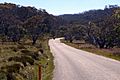
In winter, people love to go ski touring and cross-country skiing. There are trails like the Australian Alps Walking Track that are great for this. In summer, the same track is perfect for hiking. You can also enjoy mountain biking and bushwalking. Towns like Mount Beauty and Harrietville are good places to start your adventure.
Contents
History of the Bogong High Plains
The land around the Bogong High Plains has a long history. The first peoples of this land were the Indigenous Australian groups. These included the Bidhawal, Dhudhuroa, Gunai-Kurnai, and Ngarigu peoples.
Later, Europeans came to the area. They were mainly farmers who raised cattle. A big change happened in the 1940s when the Kiewa Hydroelectric Scheme began. This project built two dams, Pretty Valley Pondage and Rocky Valley Dam. It also created channels to collect water from streams. This water helps power stations make electricity. After this project, the area became more focused on tourism, especially skiing.
Scientific Research in the Alps

Scientists started studying the Bogong High Plains in 1947. A scientist named Maisie Fawcett set up special areas to see how animals grazing (eating plants) affected the mountain plants. These study areas have been watched ever since. This makes it the longest ongoing study of its kind in Australia.
Because of this research, the Victorian government stopped all cattle grazing in 2005. The studies showed that grazing was harming the delicate alpine plants. Today, many scientists still come here in summer. They study things like water, how plants change, and how the area recovers from fires. They also look at native animals like the mountain pygmy possum and alpine skink. Scientists also study how climate change might affect the area.
Bushfires and the High Plains
The Bogong High Plains has many native forests. This means the area can have bushfires. In 2003, big fires destroyed much of the forest. Many well-known huts were also burned down. The area was threatened again in 2006-07. Luckily, the weather helped, and the damage was much less that time.
Mountain Huts


There are many alpine huts in the Bogong High Plains. These huts offer shelter for people who are skiing in winter or hiking in summer. There are dozens of them, and each one is a bit different. European cattle farmers first built them in the 1830s. Now, they are not used by farmers anymore. Some are run by ski clubs, while others are not used or looked after regularly.
- Wallace's Hut
This is the oldest hut on the high plains. It was built in 1889. It has no modern facilities, so it's not used for sleeping. It is about 4.5 meters by 3.7 meters in size.
- Bogong Rover Chalet

This was the first lodge built in the area, even before the big ski resorts. Rover Scouts from Victoria started it in 1938. It has the best facilities of any hut outside a resort. It can host 35 people comfortably. It has been updated over the years. It uses solar power, gas, and wood heating. It also has its own electricity generators. There's a full kitchen and showers. Rover and Venturer Scouts use it for 13 weeks each winter.
- Cope Hut
The Ski Club of Victoria built this hut in 1929.
- Fitzgerald Hut
This was one of the older huts. A school group accidentally burned it down in 1991. It was rebuilt in 1993.
- Roper Hut
This hut burned down in the 2003 bushfire. It was rebuilt in 2008.
- Wilkinson Lodge
This hut was built by the State Electricity Commission. It was used to survey the land before the Kiewa Hydroelectric Scheme was built. Later, a ski club bought it. Members of the Melbourne Bushwalkers club then bought it in 1962 and gave it to their club. The Melbourne Bushwalkers looked after it. It was used for cross-country skiing in winter and other outdoor activities all year. It survived the 2003 bushfires. But it burned down a year later in 2004 due to a cooking accident. The woodshed is still there. The National Parks and Wildlife Service, which manages the land, has not allowed it to be rebuilt.
- Batty's Hut
This hut burned down in the 2006 bushfires.
- Cleve Cole Hut
This hut is on Mount Bogong, which is technically not part of the Bogong High Plains. It was built in 1938. It is a memorial to Cleve Cole, who died on a ski trip on Mount Bogong.
Other huts in the area include Michell Hut, Bivouac Hut, Tawonga Huts, Young's Hut, Ryder's Huts, Cope Saddle Hut, Pretty Valley Hut, Edmondson Hut, Johnston's Hut, Buckety Plains Hut, Faithful's Hut, and Langford Gap Hut.

Nature and Plants
Different Types of Plants
The Bogong High Plains has many different kinds of plants. About half of the High Plains are covered in heathlands. These are found on steeper, more protected areas. The soil here is usually thin and rocky.
About a quarter of the High Plains are grasslands. These are in more open areas and on gentle slopes. They can handle wind and frost better. Some of the best soils are in wetlands, which make up about 10% of the high plains. These are places where water stays for at least one month a year. The water helps create rich, dark soil from decaying plants.
Very rare snow patch herb fields grow in spots where snow stays for most of the summer.
Mountain Peaks
| Mountain | Height |
| Mount Nelse West | 1,893 m (6,211 ft) |
| Mount Nelse North | 1,885 m (6,184 ft) |
| Mount Fainter South | 1,883 m (6,178 ft) |
| Mount Hotham | 1,862 m (6,109 ft) |
| Mount McKay | 1,842 m (6,043 ft) |
| Mount Cope | 1,837 m (6,027 ft) |
| Spion Kopje | 1,837 m (6,027 ft) |
| Mount Jim | 1,818 m (5,965 ft) |
Mount Bogong is the tallest mountain in Victoria. It is just north of the High Plains. It's not technically part of the High Plains because the Big River separates them. There are several huts on Mount Bogong. The first one was built after a skier died there in 1936.
Mount Feathertop is another impressive mountain to the west of the Bogong High Plains. It's a popular place for bushwalking. You can reach it from Mount Hotham or Harrietville.

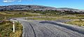
Bogong High Plains Road
The Bogong High Plains Road is a scenic road that starts in Mount Beauty. It goes up to the Falls Creek ski resort, reaching about 1720 meters high. Then it goes steeply down through Trapyard Gap. This road was fully paved in 2009.
Because it's paved, it became very popular with road cyclists. It allows for a full loop through Nelse, Omeo, Mount Hotham, Harrietville, and back to Mount Beauty. It is now used in big annual cycling events like the Peaks Challenge Falls Creek and Audax Alpine Classic ACE.
Images for kids
-
-
-
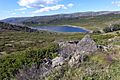
Rocky Valley Storage dam just southeast of Falls Creek.
-