
Kiewa River facts for kids
Quick facts for kids Kiewa River |
|
|---|---|

Aerial view of Kiewa River,
flowing through the town of Mount Beauty (upper right), 2009. |
|

|
|
| Other name(s) | Kiewa River East branch, West Kiewa River (and various other forms) |
| Country | Australia |
| State | Victoria |
| Region | Victorian Alps (IBRA) |
| Local government areas | Alpine, Indigo |
| Physical characteristics | |
| Main source | Kiewa River East branch below Mount Bogong, near Clover Power Station 681 m (2,234 ft) 36°47′57″S 147°13′28″E / 36.79917°S 147.22444°E |
| River mouth | confluence with the Murray River southeast of Albury and east of Wondonga 156 m (512 ft) 36°6′49″S 146°56′51″E / 36.11361°S 146.94750°E |
| Length | 109 km (68 mi) |
| Basin features | |
| River system | North-East Murray catchment, Murray–Darling basin |
| Basin size | 1,750 km2 (680 sq mi) |
| Tributaries |
|
| Reservoir | Lake Guy |
The Kiewa River is a river in Victoria, Australia. It is part of the large Murray-Darling river system. The Kiewa River flows through the Victorian Alps, a beautiful mountain area.
The Kiewa River actually has two main parts: the East Kiewa River and the West Kiewa River. They join together to form the main river. The name Kiewa comes from an Aboriginal word. It means "sweet water."
Contents
Where the Kiewa River Flows
The Kiewa River starts high up on Mount Bogong. This is Victoria's tallest mountain, standing at 1,986 metres (6,516 ft) (about 6,516 feet) tall. The main river forms when the East Kiewa River and West Kiewa River meet. This happens near the town of Mount Beauty.
The river then flows generally north. It is joined by many smaller streams along its way. Finally, the Kiewa River flows into the Murray River. This is near the towns of Albury and Wodonga. The river drops about 525 metres (1,722 ft) (1,722 feet) over its 109 kilometres (68 mi) (68 miles) journey.
River's Journey from Mountains to Plains
The West Kiewa River starts very high up. It flows quickly through forests that are almost untouched by people. This part of the river drops about 850 metres (2,790 ft) (2,789 feet) over just 29 kilometres (18 mi) (18 miles).
Further downstream, after Mount Beauty, the river flows more gently. Here, it passes through open farmland. In winter, the upper parts of the river get a lot of snow. It can get up to 90 inches (230 cm) (229 cm) of snow!
Kiewa Hydroelectric Scheme
The Kiewa River is very important for making electricity. It is part of the Kiewa Hydroelectric Scheme. This scheme uses the river's water to power generators. Dams hold back the water, creating places like Lake Guy. This water comes from the Bogong High Plains.
The McKay Creek and West Kiewa power stations are key parts of this system. They help provide electricity to Victoria, especially when a lot of power is needed.
Towns Along the River
Several towns are located in the Kiewa Valley. These include:
- Mount Beauty
- Tawonga
- Tangambalanga (also known as Kiewa Township)
- Yackandandah
The Murray Valley Highway crosses the Kiewa River near where it joins the Murray River. The Kiewa Valley Highway runs close to much of the river's path.
Fun Things to Do at Kiewa River
The Kiewa River area is a great place for outdoor activities.
Hiking and Exploring
- Tawonga Huts: These are old huts and ruins found along the West Kiewa River. They are inside the Alpine National Park. Experienced hikers can visit them.
Fishing and Paddling
- Fishing: The Kiewa River is popular for fly fishing. It has many wild brown and rainbow trout.
- Kayaking: The East and West branches of the Kiewa River are great for white water kayaking. The best time to go is in spring when the snow melts.
Winter Sports
- Cross-country skiing: The upper parts of the Kiewa River and the Bogong High Plains are very popular for Cross-country skiing during winter and early spring.
Images for kids
-
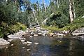
West branch of Kiewa River
-
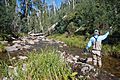
Fly fishing the west branch


