
Bundara River facts for kids
Quick facts for kids Bundara |
|
|---|---|

Bundara River looking upstream from the Omeo Highway, north of Anglers Rest
|
|

|
|
| Country | Australia |
| State | Victoria |
| Region | Victorian Alps (IBRA), East Gippsland |
| Local government area | East Gippsland Shire |
| Physical characteristics | |
| Main source | Victorian Alps east of Mount Hotham 1,420 m (4,660 ft) 36°57′S 147°14′E / 36.950°S 147.233°E |
| River mouth | confluence with the Big River Anglers Rest 650 m (2,130 ft) 36°58′43″S 147°29′39″E / 36.97861°S 147.49417°E |
| Length | 30 km (19 mi) |
| Basin features | |
| River system | North-East Murray catchment, Murray-Darling basin |
| National park | Alpine National Park |
The Bundara River is a river in Victoria, Australia. It flows through the East Gippsland and alpine areas. This river is part of the larger Murray-Darling river system, which is very important for Australia. It used to be called the Bundara Mungee River or Bundarah River.
Contents
Where the Bundara River Flows
The Bundara River starts in the Australian Alps, specifically east of Mount Hotham. This area is part of the Alpine National Park. The river begins at a high point, about 1,420 meters (4,659 feet) above sea level.
It flows generally towards the east. The river travels through the national park for most of its journey. After flowing for about 30 kilometers (19 miles), it joins another river called the Big River. This meeting point is near a place called Anglers Rest.
The Bundara River drops a lot in height during its journey. It goes down about 770 meters (2,526 feet) from where it starts to where it meets the Big River. The Omeo Highway crosses over the river about 2 kilometers (1.2 miles) north of Anglers Rest.
Smaller Streams Joining the River
Many smaller streams flow into the Bundara River. These smaller streams are called tributaries. Some important tributaries include High Plains Creek, Waterfall Creek, and Tea Tree Creek.
These streams mostly come from the southern slopes of mountains like Mount Jim, Mount Bundara, and Mount Cope. These mountains are quite tall, with Mount Jim being about 1,818 meters (5,965 feet) high.
How Healthy is the River?
The Bundara River and its smaller streams are mostly protected because they are inside the Alpine National Park. This means the river is generally in very good condition. Most of the waterways in this area are considered healthy.
The land around the river is covered by thick forests. Even though there has been some clearing of land and damage to the river banks from livestock, the water environment is still very good for plants and animals.
The Bundara River is well-known as a great spot for fishing, especially for brown trout. The river is part of a special program called the Victorian River Health Program. This program helps keep rivers healthy across Victoria.
In 2003, huge bushfires affected the forests around the Bundara River. These fires burned a very large area for almost two months. The fires caused some damage to the river's health for a while afterward.
Images for kids
-
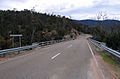
Omeo Highway crossing the Bundara River near Anglers Rest
-
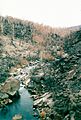
Devastated bushland on the Bundara River near Anglers Rest resulting from the 2003 Eastern Victorian alpine bushfires


