
Adelaide facts for kids
Quick facts for kids AdelaideSouth Australia |
|||||||||
|---|---|---|---|---|---|---|---|---|---|
|
Adelaide city centre
General Post Office
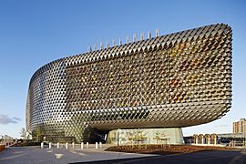
SAHMRI
University of South Australia
Elder Park and Adelaide Oval
Adelaide Entertainment Centre
|
|||||||||

Map of Adelaide, Australia, printable and editable
|
|||||||||

Adelaide
Location in Australia
|
|||||||||
| Population | 1,418,455 (2022) (5th) | ||||||||
| • Density | 426/km2 (1,100/sq mi) | ||||||||
| Established | 28 December 1836 | ||||||||
| Area | 3,259.8 km2 (1,258.6 sq mi) | ||||||||
| Time zone | ACST (UTC+9:30) | ||||||||
| • Summer (DST) | ACDT (UTC+10:30) | ||||||||
| Location | |||||||||
| LGA(s) | 19 municipalities across Metropolitan Adelaide | ||||||||
| State electorate(s) | Various (34) | ||||||||
| Federal Division(s) | Spence, Makin, Hindmarsh, Adelaide, Sturt, Boothby, Kingston | ||||||||
|
|||||||||

_(33505366456)_(cropped).jpg)

.jpg)

.jpg)
.jpg)


Adelaide (pronounced AD-il-ayd) is the capital city of South Australia. It's also the fifth most populated city in Australia. The name "Adelaide" can mean the whole city area, including the Adelaide Hills, or just the city centre. People from Adelaide are called Adelaideans.
The traditional owners of the land where Adelaide is built are the Kaurna people. In their language, the city centre and its surrounding parks are called Tarndanya.
Adelaide is located on the Adelaide Plains. This is between the Gulf St Vincent to the west and the Mount Lofty Ranges to the east. The city area stretches about 20 kilometres (12 miles) from the coast to the hills. It also goes about 96 kilometres (60 miles) from Gawler in the north to Sellicks Beach in the south.
The city was named after Adelaide of Saxe-Meiningen, who was the wife of King William IV. It was founded in 1836 as a planned capital for a British province. This province was unique because it was settled by free people, not convicts. Colonel William Light, one of Adelaide's founders, designed the city centre. His design, called "Light's Vision", is now a national heritage site. It features a grid layout with wide streets, large public squares, and green park lands all around the city centre.
Adelaide was different from other Australian cities because it was settled by free people. It was Australia's third-largest city for a long time. It became known as the "City of Churches" because many different religions were welcomed here. Adelaide was also famous for its car industry and hosted the Australian Grand Prix from 1985 to 1995.
Today, Adelaide is known for its many festivals and sports events. It's also famous for its delicious food and wine, beautiful coastline, and hills. The city has important defence and manufacturing industries. It's also a growing hub for space technology, with the Australian Space Agency based here. Adelaide is often ranked as a city with a high quality of life. In 2024, Architectural Digest even called it the most beautiful city in the world.
As the main centre for government and business in South Australia, Adelaide has many important institutions. Most of these are in the city centre, along streets like North Terrace and King William Street. Adelaide is also considered a "global city" because it connects local businesses to the world economy.
Contents
Discovering Adelaide's Past

Before European Settlement
Before 1836, the land around Adelaide was home to the Kaurna Aboriginal nation. Their culture and language were almost lost after European settlement. However, thanks to old records, their language and culture are now being brought back to life.
How Adelaide Began in the 1800s


South Australia officially became a British colony on 28 December 1836. This happened near The Old Gum Tree in what is now Glenelg North. This day is still celebrated as Proclamation Day. Colonel William Light designed the city's layout.
Adelaide was planned for free immigrants. It promised freedom and religious tolerance. Unlike other Australian cities like Sydney or Melbourne, Adelaide was not started as a convict settlement. This was because of ideas from Edward Gibbon Wakefield. He believed land should be sold at a price that encouraged people to work hard. Money from land sales helped bring working-class people to the colony.

Early Adelaide faced some challenges. People thought there would be little crime, so no jail was planned at first. But crime did happen, and the South Australia Police force was created in 1838. The Adelaide Gaol began construction in 1841.
Adelaide's economy started to grow in 1838 with livestock arriving. Wool production was important early on. By 1860, wheat farms were common. Silver was discovered in Glen Osmond in 1841, which helped the city's economy. By 1845, Adelaide was exporting meat, wool, wine, fruit, and wheat.
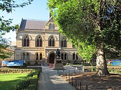
South Australia became a self-governing colony in 1856. This meant it could make its own laws. In 1860, the Thorndon Park reservoir opened, providing clean water. Gas street lighting came in 1867. The University of Adelaide was founded in 1874. The Art Gallery of South Australia opened in 1881.
Adelaide in the 1900s

Electric street lighting arrived in 1900, and electric trams started in 1909. After World War I, Adelaide grew and became the third-largest city in Australia. However, this prosperity didn't last. The city faced droughts and the Great Depression in the 1930s.
During World War II, Adelaide became a safe place for manufacturing. This helped the city grow its industries. Car companies like General Motors Holden and Chrysler used factories around Adelaide. This changed the city from an agricultural centre to a modern industrial hub.
A pipeline brought water from the Murray River to Adelaide in 1954. The Adelaide International Airport opened in 1955. Flinders University was built in the 1960s.
The 1970s saw a "cultural revival" in Adelaide. The city became a centre for the arts. The Adelaide Festival of Arts began in 1960. The South Australian Film Corporation and State Opera of South Australia were also created.
Adelaide hosted the Formula One Australian Grand Prix from 1985 to 1995. This was a big event for the city.
Adelaide in the 2000s

In the early 2000s, the government spent a lot on improving Adelaide's infrastructure. The Adelaide Oval was upgraded for AFL games. A new Royal Adelaide Hospital was built. The tram line was extended, and railway lines were improved.
Many old buildings were given new life. The Torrens Building became home to international universities. The government also built a desalination plant to make drinking water from the sea. This was a backup plan in case of droughts.
Adelaide's festivals like the Adelaide Festival, Fringe, and Womadelaide became annual events. These, along with the Adelaide 500 car race, make March a very busy and exciting time, known as "Mad March".
Adelaide's Landscape

Adelaide is on the Adelaide Plains, between the Gulf St Vincent and the Mount Lofty Ranges. The city stretches about 20 km (12 miles) from the coast to the hills. It extends 90 km (56 miles) from Gawler in the north to Sellicks Beach in the south.
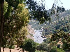
The highest point in Adelaide is Mount Lofty, which is 727 metres (2,385 feet) tall. Before European settlement, much of Adelaide was bushland. Today, most of the original plants have been cleared. What's left can be found in places like Cleland Conservation Park and Belair National Park.
Adelaide gets its water from several reservoirs, like Happy Valley Reservoir and Mount Bold Reservoir.
How Adelaide is Designed

Adelaide is a planned city. Colonel William Light designed it with a grid layout. The city centre has five main squares and is surrounded by a ring of parks called the Adelaide Park Lands. Light's design was very smart. It gave Adelaide wide roads and an easy-to-understand layout.

As the city grew, it expanded beyond Light's original plan. Many smaller towns were swallowed up by Adelaide's growth. New roads like the South Eastern Freeway and Southern Expressway were built to handle the extra traffic.

Historically, Adelaide's homes were mostly single-storey houses on large blocks of land. Many were built with bricks or stone. This was because local timber was scarce. Today, there's a mix of older and newer homes.
Adelaide's Weather
Adelaide has a Mediterranean climate. This means it has warm, dry summers and mild, short winters. Most of the rain falls in winter. Summers can be hot and dry, with little rain. Winters are usually wet, especially in June. Snow is very rare in the city, but it can sometimes fall in the nearby hills.
How Adelaide is Governed

Adelaide is the capital of South Australia, so it's where the state government is based. The Parliament of South Australia has two parts: the South Australian House of Assembly and the South Australian Legislative Council. Elections are held every four years.
The Government of South Australia works closely with the Adelaide City Council. The City of Adelaide manages the city centre and its surrounding parklands. It's the oldest local government in Australia, started in 1840. The head of the City of Adelaide is the Lord Mayor.
Local Councils in Adelaide
The greater Adelaide area is divided into 19 different local government areas. Each of these areas has its own council that manages local services.
Who Lives in Adelaide?

People who live in Adelaide are called Adelaideans. Adelaide is Australia's fifth-largest city. In 2020, its population was over 1.3 million people. About 77% of all people in South Australia live in Adelaide.
Most people in Adelaide live in houses. There are also many townhouses and apartments, especially in newer areas.
Adelaide's population is getting older faster than other Australian cities. More than a quarter of Adelaide's people are aged 55 or older. The city also has fewer children (under 15) compared to the national average.
Where People Come From
| Birthplace | Population |
|---|---|
| Australia | 884,250 |
| England | 80,795 |
| India | 26,270 |
| Mainland China | 23,919 |
| Italy | 17,398 |
| Vietnam | 13,932 |
| Philippines | 10,204 |
| New Zealand | 9,882 |
| Germany | 8,242 |
| Greece | 8,022 |
| Malaysia | 7,465 |
| Afghanistan | 5,847 |
| South Africa | 5,587 |
At the 2016 census, the most common backgrounds for people in Adelaide were:
- English (39%)
- Australian (33%)
- Scottish (8.7%)
- Irish (8.5%)
- German (7.2%)
- Italian (7.2%)
- Chinese (4.1%)
About 31.8% of Adelaide's population was born overseas in 2016. The largest groups came from England, India, China, Italy, and Vietnam.
Many suburbs have strong cultural communities. For example, Newton and Payneham have large Greek and Italian communities. Vietnamese populations live in areas like Woodville. Indian and Sri Lankan migrants have settled in suburbs like Blair Athol. Afghan communities are found in places like Para Hills. Chinese migrants often choose eastern suburbs like Kensington Gardens.

About 1.4% of Adelaide's population identifies as Indigenous Australians.
Languages Spoken
In 2016, 75.4% of people in Adelaide spoke English at home. Other common languages were Italian, Mandarin, Greek, and Vietnamese.
Religions in Adelaide

Adelaide was founded on the idea of religious freedom. This is why it's known as The City of Churches. However, about 28% of people in Adelaide said they had no religion in 2011. This is higher than the national average.
More than half of Adelaide's population identifies as Christian. The largest Christian groups are Catholic, Anglican, and Uniting Church.
The Jewish community in Adelaide dates back to 1840. The Central Adelaide Mosque is considered Australia's oldest permanent mosque.
Adelaide's Economy

The biggest job sector in South Australia is health care and social assistance. This has been the largest employer since 2006–07. The Adelaide Hills wine region is also very important for wine production and sales.
Retail trade (shops and stores) is the second-largest employer. Manufacturing, defence technology, high-tech electronics, and research also play a big part in Adelaide's economy.
Adelaide was once a major car manufacturing hub. The Holden Elizabeth Plant made almost half of all cars produced in Australia. However, this factory closed in 2017.
News Corporation, a global media company, was founded in Adelaide. Large Australian companies like Santos (oil and gas) and Coopers (beer) are also based here.
In 2018, Adelaide was chosen as the headquarters for the new Australian Space Agency. This agency aims to greatly increase Australia's space industry and create many new jobs by 2030.
Defence Industry
,_enters_Pearl_Harbor_for_a_port_visit_after_completing_exercises_in_the_Pacific_region.jpg)
Adelaide is a major centre for Australia's defence industries. Many defence technology companies, like BAE Systems Australia and Lockheed Martin Australia, are located here. ASC Pty Ltd, which builds submarines and destroyers for the Royal Australian Navy, is also based in Adelaide.
Learning and Research in Adelaide
,_Barr_Smith_Library_--_2019_--_0677.jpg)
Education is a growing part of Adelaide's economy. The government wants to make Adelaide "Australia's education hub." Many international students come to study here. Adelaide is also the birthplace of three Nobel Prize winners: William Lawrence Bragg, Howard Florey, and Robin Warren. They all studied at St Peter's College and the University of Adelaide.
Schools in Adelaide
Adelaide has two main school systems: public schools run by the government and private schools (independent and Catholic). Students follow the Australian Curriculum. For Years 10-12, students work towards the South Australian Certificate of Education (SACE). Some schools also offer International Baccalaureate programs.
For students who can't attend a regular school, like those in remote areas, the Open Access College provides online teaching.
Universities in Adelaide

Adelaide has three public universities: the University of Adelaide, the University of South Australia, and Flinders University. There is also one private university, Torrens University Australia.
The University of Adelaide is one of Australia's oldest universities and is highly ranked worldwide. The University of South Australia is also very large. Flinders University is based in the southern suburbs.
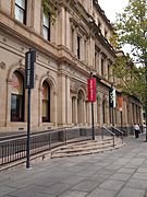
The historic Torrens Building in Victoria Square hosts campuses for international universities like Carnegie Mellon University and University College London.
There are also several TAFE campuses. These provide vocational training for different jobs. The Adelaide College of the Arts offers training in visual and performing arts.
Research in Adelaide
.jpg)
Adelaide is home to many research institutes. These include the Royal Institution of Australia. Many research organisations are grouped together in different areas of the city:
- Near North Terrace: SA Pathology, Hanson Institute, National Wine Centre, South Australian Health and Medical Research Institute (SAHMRI).
- The Waite Research Precinct: SARDI, AWRI, CSIRO labs.
- Edinburgh, South Australia: DSTO, BAE Systems (Australia), Lockheed Martin Australia.
- Technology Park (Mawson Lakes): BAE Systems, Optus, Raytheon.
- Research Park at Thebarton: Businesses in engineering, biotechnology, and IT.
- The Basil Hetzel Institute for Translational Health Research.
- The Joanna Briggs Institute for healthcare research.
-
Mitchell Building, University of Adelaide
-
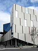
The Hawke Building, part of UniSA's City West Campus
-
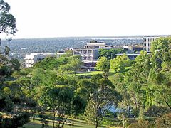
Flinders University buildings from the campus hills
-
Torrens University
-
South Australian Health and Medical Research Institute (SAHMRI)


Adelaide's Cultural Scene


Adelaide has a rich cultural life. Early immigrants from Germany brought their traditions, including vine cuttings that started the famous wineries of the Barossa Valley.
The Royal Adelaide Show is a big annual event, like a state fair, that started in 1839.
Adelaide's arts scene really grew in the 1960s and 1970s. The famous Adelaide Festival of Arts began in 1960. This also led to the Adelaide Fringe, a huge festival of performances. The Adelaide Festival Centre was built, and the South Australian Film Corporation was created.
Many other festivals have started since then, like Adelaide Writers' Week, WOMADelaide (world music), the Adelaide Cabaret Festival, Tasting Australia (food and wine), and Illuminate Adelaide (lights and art). With so many events in early March, it's called "Mad March."
Adelaide also hosts the Adelaide Language Festival. There are many international cultural fairs, like the German Schützenfest and Greek Glendi. Adelaide has the world's largest Christmas parade every year.

Cultural Places on North Terrace
Many of Adelaide's cultural places are along North Terrace. These include the Art Gallery of South Australia, the South Australian Museum, and the State Library of South Australia. Nearby are the Adelaide Botanic Garden and the National Wine Centre. The Migration Museum is Australia's oldest museum of its kind.
The Lion Arts Centre is home to art galleries and dance studios. The Mercury Cinema and JamFactory (for ceramics and design) are also close by.
Places for Shows and Music
_(33505366456).jpg)
The Adelaide Festival Centre is a main spot for cultural events. It has theatres like the Dunstan Playhouse and Festival Theatre. Other places for live music and shows include the Adelaide Entertainment Centre, Adelaide Oval, Thebarton Theatre, and Her Majesty's Theatre.
Music in Adelaide

Adelaide is known as a "City of Music" by UNESCO. It has many live music venues. Places like the Grace Emily and the Crown & Anchor are popular. New laws protect live music venues in the city.
Adelaide has produced many famous musicians and bands. These include the Adelaide Symphony Orchestra, rock bands like The Angels and Cold Chisel, and pop stars like Sia and Guy Sebastian.
Sports in Adelaide


The main sports played professionally in Adelaide are Australian Rules football, soccer, cricket, netball, and basketball.
Adelaide has two teams in the Australian Football League: the Adelaide Football Club (Crows) and Port Adelaide Football Club (Power). Both play at Adelaide Oval. The local league, the South Australian National Football League (SANFL), is the oldest football league in Australia.
Adelaide also has a soccer team, Adelaide United, which plays in the A-League. Their home ground is Coopers Stadium.
For basketball, Adelaide has the men's team Adelaide 36ers (NBL) and the women's team Adelaide Lightning (WNBL). The Adelaide Thunderbirds play netball in the Suncorp Super Netball championship.

Since 1999, Adelaide has hosted the Tour Down Under bicycle race. This is a major international cycling event.
Adelaide has an ice hockey team, Adelaide Adrenaline, which plays at the IceArenA.

Adelaide hosted the Australian Grand Prix for Formula One racing from 1985 to 1995. Now, the city hosts the Adelaide 500 for V8 Supercar racing on a modified version of the same street circuit.
Adelaide has a horse racing track, Morphettville Racecourse. It also has Globe Derby Park for harness racing and Greyhound Park for greyhound racing.
The World Solar Challenge race, where teams race solar-powered cars, starts in Darwin and finishes in Adelaide.
Getting Around Adelaide
Transport Systems

Adelaide has a public transport system called Adelaide Metro. It includes buses, a special busway called the O-Bahn Busway, seven train lines, and a small tram network. The tram network was mostly removed in the 1950s but has been expanded recently.
Adelaide is known as a "twenty-minute city" because it's usually quick to travel from the suburbs to the city centre. However, as the city grows, traffic can get busy.

Adelaide has several major roads:
- The South Eastern Freeway (M1) connects Adelaide to the Adelaide Hills and beyond.
- The Southern Expressway (M2) links the southern suburbs to the city.
- The North-South Motorway (M2) is a big project that will create a major north-south road without traffic lights.
- The Port River Expressway (A9) connects Port Adelaide to the main roads.
- The Northern Expressway (M2) bypasses the northern suburbs.
- The Northern Connector links the North-South Motorway to the Northern Expressway.
-
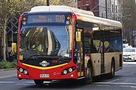
A bus on King William Street.
-
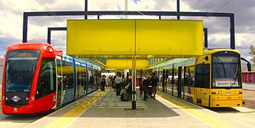
An Adelaide Metro tram.
-
The Mount Osmond Interchange on the South Eastern Freeway.
.jpg)


Airports

Adelaide has two main airports for public use: Adelaide Airport and Parafield Airport. Adelaide Airport is the main one, serving millions of passengers each year for both international and domestic flights. Parafield Airport is used for smaller planes and pilot training.
There's also a military airport, Edinburgh Airport, in the northern suburbs.
Energy Supply
Adelaide gets its electricity from various sources. There are gas-fired power stations and a growing amount of wind power and solar power. South Australia is a leader in wind energy in Australia.
After a big blackout in 2016, South Australia worked with Tesla to build the world's largest electricity battery at Hornsdale Power Reserve. This has made the state's power supply much more secure.
Water Supply

Adelaide's water comes from seven reservoirs. When there isn't enough rain, water is also pumped from the River Murray.
A sea-water desalination plant was built to turn seawater into drinking water. This plant can provide a lot of water, especially during droughts.
Communications
Adelaide has a citywide free Wi-Fi network called AdelaideFree WiFi. It covers most of the city centre.
Adelaide's Sister Cities
The City of Adelaide has special partnerships with other cities around the world. These are called "sister cities" and help with cultural, educational, and business exchanges. Adelaide has five sister cities:
 Austin, Texas, United States (since 1983)
 Christchurch, New Zealand (since 1972)
 George Town, Penang, Malaysia (since 1973)
 Himeji, Hyogo, Japan (since 1982)
 Qingdao, Shandong, China (since 2013)
Adelaide also has "Friendship Cities" which are informal partnerships:
- Dalian, Liaoning, China
- Chengdu, Sichuan, China
 Barcelona, Catalunya, Spain (since 2024)
See also
 In Spanish: Adelaida (Australia) para niños
