Mount Bold Reservoir facts for kids
Quick facts for kids Mount Bold Reservoir dam |
|
|---|---|

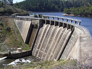
The dam wall at Mount Bold Reservoir.
|
|
| Location | South Australia |
| Coordinates | 35°07′12″S 138°42′04″E / 35.120°S 138.701°E |
| Construction began | 1932 |
| Opening date | 1938 |
| Construction cost | $1.1 million |
| Dam and spillways | |
| Height | 50.8 m (167 ft) |
| Length | 192 m (630 ft) |
| Reservoir | |
| Total capacity | 46,180 ML (1,631×106 cu ft) |
| Surface area | 3.08 km2 (1.19 sq mi) |
The Mount Bold Reservoir is the biggest reservoir in South Australia. It can hold more than 46,000 megalitres of water. A megalitre is a huge amount, equal to one million litres!
This important reservoir was built on the Onkaparinga River system. It took six years to build, from 1932 to 1938. The total cost was about A$1.1 million.
The water from Mount Bold Reservoir does not go directly into homes. Instead, water is let out when needed to keep levels steady at Clarendon Weir. Much of this water then travels to Happy Valley Reservoir. From there, it helps supply water to parts of the Mount Lofty Ranges and also to Adelaide.
Contents
Making the Reservoir Bigger
In 1964, a big upgrade was finished at the reservoir. The dam wall was made 6.4 metres taller. This change allowed the reservoir to hold about 17,000 more megalitres of water.
Power from Water
Mount Bold Reservoir used to make its own electricity. It had a small hydro-electricity plant. This plant used the power of flowing water to create energy. However, this was stopped in 1961. Today, people are thinking about Mount Bold as a possible place for a new, small hydro-electricity generator.
Plans for Expansion
In June 2007, the Government of South Australia started looking into a big plan. They wanted to make the reservoir five times bigger. This would mean it could hold 240 gigalitres of water. A gigalitre is one billion litres! This huge project was estimated to cost A$850 million.
However, some groups did not agree with this plan. Other political groups said it would not bring any new water. An expert in nature, David Paton, also worried. He said the plan could harm the animals and plants living nearby.
Overflowing with Rain
On September 26, 2010, something special happened. Mount Bold Reservoir was opened for the first time since 2005. This was because it had received a lot of rain in the days before.
When the water was released, it helped clean out the Onkaparinga Catchment area. It caused some roads to flood, but it also washed away old debris. This debris had been building up for many years.
2007 Bushfire
In January 2007, a large bushfire swept through the Mount Bold Valley area. This area includes properties between Kangarilla and Echunga. The fire started on January 10 in the evening. It burned very strongly through the night.
The fire destroyed two houses and damaged more than ten sheds. Sadly, it also killed farm animals and horses. Two people were hurt, and fences were damaged. The next day, the fire moved towards Echunga. Luckily, firefighters were able to stop it.
Images for kids
 | John T. Biggers |
 | Thomas Blackshear |
 | Mark Bradford |
 | Beverly Buchanan |


