Onkaparinga River facts for kids
Quick facts for kids Onkaparinga |
|
|---|---|

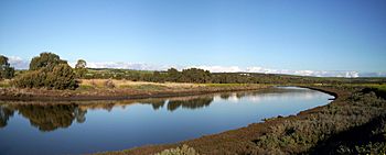
Onkaparinga River estuary
|
|
|
Location of the river mouth in South Australia
|
|
| Native name | Kaurna: Ngangkiparri |
| Country | Australia |
| State | South Australia |
| Region | Southern Adelaide |
| Local government area | City of Onkaparinga |
| Towns | Woodside, Oakbank, Clarendon |
| Physical characteristics | |
| Main source | Mount Lofty Range between Charleston and Mount Torrens 422 m (1,385 ft) |
| River mouth | Gulf St Vincent between Port Noarlunga South and Port Noarlunga 0 m (0 ft) 35°09′53″S 138°28′10″E / 35.164660°S 138.469520°E |
| Length | 88 km (55 mi) |
| Basin features | |
| Basin size | 562 km2 (217 sq mi) |
| Protected areas | Encounter Marine Park Onkaparinga River National Park Onkaparinga River Recreation Park Port Noarlunga Reef Aquatic Reserve |
The Onkaparinga River is a special river in South Australia. It is known as Ngangkiparri or Ngangkiparingga in the Kaurna language. This name means "place of the women’s river."
The river starts in the Mount Lofty Ranges. It then flows into an estuary, which is where the river meets the sea. This estuary stretches from Old Noarlunga to the river's mouth. The mouth is located between the towns of Port Noarlunga South and Port Noarlunga.
Contents
River's Name and Early History
The name Onkaparinga comes from the Kaurna people. They are the traditional owners of this land. Their word for the river was Ngangkiparri or Ngangkiparingga. The part "-ngga" means "at," so it means "at the women's river."

In 1837, a man named Colonel William Light explored the area. He was the first Surveyor-General of South Australia. He first called it Field's River. This was to honor Lieutenant William George Field, who helped survey the river's mouth. However, the next Governor, George Gawler, soon changed the name back to the original Indigenous name.
The first Europeans to explore the river's source were Dr. George Imlay and John Hill. They did this in January 1838.
Journey of the Onkaparinga River
The Onkaparinga River begins its journey in the Mount Lofty Ranges. It starts between the towns of Mount Torrens and Charleston. From there, it flows mostly southwest. It passes south of the main city of Adelaide. Finally, it reaches its mouth at Port Noarlunga.
The area that collects water for the river is called its catchment area. This area is larger than 500 square kilometres (190 square miles). Parts of the river are protected. These protected areas include the Encounter Marine Park, the Onkaparinga River National Park, the Onkaparinga River Recreation Park, and the Port Noarlunga Reef Aquatic Reserve. The river drops 422 metres (1,385 ft) in height over its 88-kilometre (55 mi) course.

The Onkaparinga River is the second most important river in the Adelaide area. The River Torrens is the first. The Onkaparinga River is a key source of fresh water for Adelaide.
Dams and Water Supply
The Mount Bold Reservoir was built on the river between 1932 and 1938. This dam is about 20 kilometres (12 miles) inland from the coast. A lot of the river's water is sent through a tunnel. This tunnel goes from the Clarendon Weir to the Happy Valley Reservoir. The Happy Valley Reservoir provides about 40% of Adelaide's water.
Most years, extra water is pumped into the reservoir. This water comes from the River Murray. It travels through a pipeline from Murray Bridge.
Downstream from the Mount Bold Reservoir is the Clarendon Weir. Water is only let out from the Clarendon Weir when needed. This helps keep the water levels steady.
The Onkaparinga Gorge and Estuary
The Onkaparinga Gorge is a deep valley. It stretches from Clarendon to Old Noarlunga. After the gorge, the river forms an estuary. This estuary goes from Old Noarlunga to the river's mouth. The mouth is between Port Noarlunga and Port Noarlunga South. This estuary is a very important place. Many local marine fish species come here to breed.
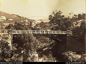
Bridges and Crossings
The Coast to Vines rail trail crosses the river. It is just west of where Main South Road crosses. The Seaford railway line also goes over the river. It uses a 1.2-kilometre (0.75 mi) elevated bridge. This bridge is called the Onkaparinga Valley Bridge. It was built between 2011 and 2014.
 | Laphonza Butler |
 | Daisy Bates |
 | Elizabeth Piper Ensley |


