Charleston, South Australia facts for kids
Quick facts for kids CharlestonSouth Australia |
|||||||||||||||
|---|---|---|---|---|---|---|---|---|---|---|---|---|---|---|---|

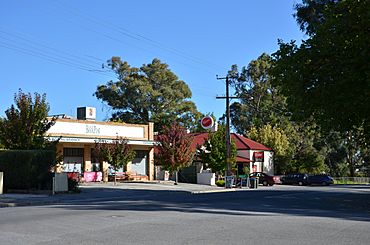
Charleston Hotel and general store
|
|||||||||||||||
| Postcode(s) | 5244 | ||||||||||||||
| LGA(s) | Adelaide Hills Council | ||||||||||||||
| State electorate(s) | Kavel | ||||||||||||||
| Federal Division(s) | Mayo | ||||||||||||||
|
|||||||||||||||
Charleston is a small town located in the beautiful Adelaide Hills region of South Australia. It sits on the Onkaparinga Valley Road, between the towns of Woodside and Mount Torrens. This road is a main path connecting the Adelaide Hills to the famous Barossa Valley. Charleston is also very close to where the River Onkaparinga begins its journey.
About Charleston
A Bit of History
The town of Charleston was planned in 1857 by a man named Charles Dunn. He was the brother of a well-known miller, John Dunn. The town might have first been called "Charlestown." However, the name "Charleston" quickly became the most common way to spell it in newspapers.
Life in Charleston
Most of the shops and businesses in Charleston are found along the Onkaparinga Valley Road. The largest number of homes are located on Newman Road.
Charleston has a special community post office called The Bookpost. It's more than just a place to send mail. It's also a bookshop, an internet cafe, and a general store where you can buy many different things.
Right next to The Bookpost, you'll find the Charleston Hotel. This hotel became famous across Australia. It was a main part of a car advertisement. This ad was inspired by Slim Dusty's popular song, "Answer to a Pub With No Beer."
Getting Around
Charleston is part of the Adelaide Metro bus system. This means you can catch a bus to and from the town. The 835 bus route serves Charleston, especially during school terms.
Long ago, Charleston had a railway line. This line ran from Balhannah towards Mount Pleasant. However, the railway line was closed down in 1963. The tracks were removed soon after. Today, the path where the railway used to be is now a popular cycling and walking trail called the Amy Gillett Bikeway.
 | Emma Amos |
 | Edward Mitchell Bannister |
 | Larry D. Alexander |
 | Ernie Barnes |


