Port Noarlunga, South Australia facts for kids
Quick facts for kids Port NoarlungaAdelaide, South Australia |
|||||||||||||||
|---|---|---|---|---|---|---|---|---|---|---|---|---|---|---|---|

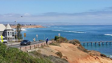
Port Noarlunga jetty and reef, viewed from Witton Bluff
|
|||||||||||||||
| Established | 1856 | ||||||||||||||
| Postcode(s) | 5167 | ||||||||||||||
| Location | 27 km (17 mi) south of Adelaide | ||||||||||||||
| LGA(s) | City of Onkaparinga | ||||||||||||||
| Region | Southern Adelaide | ||||||||||||||
| County | Adelaide | ||||||||||||||
| State electorate(s) | Reynell | ||||||||||||||
| Federal Division(s) | Kingston | ||||||||||||||
|
|||||||||||||||
|
|||||||||||||||
| Footnotes | Location Climate Adjoining suburbs |
||||||||||||||
Port Noarlunga is a lovely seaside suburb in South Australia. It's part of the City of Onkaparinga, about 30 kilometres (19 miles) south of Adelaide city centre. This area was first built as a sea port. Today, it's a popular spot for holidays or for people who live there and travel to Adelaide for work.
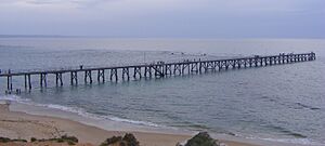
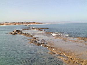
Port Noarlunga has a long jetty that stretches out to a natural reef. This reef is about 1.6 kilometres (0.99 miles) long and you can see it when the tide is low. The local Kaurna people know this place as Tainbarang or Tainbarilla. It's a special place for them because of a freshwater spring. This spring is said to have been made from the tears of Tjilbruke, a very important creator being in their stories. There's even a stone monument at Tutu Wirra Reserve on Witton Bluff to remember this second spring.
The Onkaparinga River forms the southern edge of the suburb. This includes a tidal estuary, which is where the river meets the sea. To the west is the coastline of Gulf St Vincent. Christies Beach is to the north, and Noarlunga Centre and Noarlunga Downs are to the east.
Contents
History of Port Noarlunga
Early Days and Kaurna People
Before Europeans arrived, the Kaurna people lived in this area. They were the traditional owners of the land. Port Noarlunga is a very important sacred site for the Kaurna. It's linked to their Dreamtime stories about the creator ancestor Tjilbruke.
European Settlement and Development
The first European to record seeing this area was Captain Collet Barker in 1831. He was exploring the Onkaparinga River. In 1837, explorers like C.W. Stuart and Colonel William Light also visited the region. The area was opened for public settlement in 1839. By 1841, about 150 people lived here.
A whaling station was set up near the Onkaparinga River mouth in 1841. It was run by George Heppenstall. This station had 25 men and two boats. They used a small punt to cut up the whales. Heppenstall built a house called "Whaleview," which was likely the first permanent building here. The whaling stopped in 1843.
The government officially surveyed Port Noarlunga town in 1859. It was meant to be a port for goods from the town of Noarlunga. But the Onkaparinga River mouth wasn't good for big boats. So, goods were moved by barges and then by horse-drawn rail to the jetty.
The Jetty and Holiday Fun
The first jetty was built in 1855. It was about 30 metres south of where the current jetty is. Storms in the early 1900s destroyed it. The current jetty was built in 1921.
In the early 1900s, Port Noarlunga was a popular holiday spot. People loved the beautiful beach. In summer, there were fun fairs and rowing on the river. The Port Noarlunga Post Office opened around 1909.
Becoming an Adelaide Suburb
Over time, Adelaide grew bigger. In the 1960s and 1970s, more houses were built nearby. The South Australian Housing Trust developed areas like Christies Beach. When the train line was extended to Noarlunga Centre in 1978, Port Noarlunga became more of an outer suburb of Adelaide. It slowly lost its fame as a holiday destination.
Important Historical Places
- There's a stone monument in the Tutu Wirra Reserve. It marks a spot near a freshwater spring. This spring was created by the Kaurna ancestor Tjilbruke.
State Heritage Sites
Several places in Port Noarlunga are listed as "state heritage places." This means they are important historical sites in South Australia:
- Perry Homestead, at 80 Murray Road.
- A dwelling and other buildings at 53 Old Honeypot Road.
- Port Noarlunga Hotel, at 29 Saltfleet Street.
- Sauerbier's House, at 21 Wearing Street.
Things to See and Do in Port Noarlunga
The Beach and Jetty Fun
Port Noarlunga beach is a favorite spot for both visitors and locals. It has safe swimming areas watched over by two surf life saving clubs. The beach was even featured in a 2012 book called 101 Best Australian Beaches.
The current timber jetty stretches from the shore over the beach and out to the reef. It's lit up at night. The jetty has three staircases. One goes down to the beach, and two lead into the water. These are great for swimmers, snorkelers, and divers. The jetty is also easy for wheelchairs and scooters to use.
In 2018, strong winds damaged the stairs at the reef end of the jetty. New, stronger stairs with multiple platforms were built in 2020. You can sometimes see the remains of the old jetty's wooden piles about 30 metres south of the current jetty, especially after storms.
Exploring the Township
Port Noarlunga has a small main street called Gawler Street. It's a busy place for visitors and locals. You'll find cafes, a pub, a fish and chip shop, a surf shop, and other local businesses. The old "Institute" building, built in 1924, is now a community center.
Discovering Port Noarlunga Reef
Port Noarlunga Reef is known as one of South Australia's best places for snorkeling. It's also popular with underwater photographers. This narrow reef is about 400 metres (1,300 feet) offshore and 1.6 kilometres (0.99 miles) long. It was formed from an ancient sand dune.
The reef runs parallel to the shore and has two parts, with a gap in between. It's a fantastic spot for scuba diving and snorkelling. You can see over 200 types of marine plants and more than 70 kinds of fish. There's even a self-guided diving trail. It was set up in 1994 and has 12 glass plaques. These plaques point out interesting parts of the reef's ecosystem.
Port Noarlunga Reef Aquatic Reserve
The Port Noarlunga Reef Aquatic Reserve is one of South Australia's special aquatic reserves. It was created in 1971 to protect the reef life and the nearby river estuary. In 1993, the reserve grew to include Horseshoe Reef at Christies Beach.
Today, the reserve stretches along the coast from Onkaparinga Head in Port Noarlunga South to Gulfview Road in Christies Beach. It also includes the Onkaparinga River up to Main South Road at Old Noarlunga. The reserve covers about 527 hectares (1,300 acres).
Fishing is limited here. You can only use a rod and handline. Small hand nets are allowed for catching shrimp for bait in the estuary and river. No fishing is allowed within 25 metres (82 feet) of Horseshoe and Port Noarlunga Reefs. You can only fish from the jetty and the beach at Port Noarlunga.
Port Noarlunga's Underwater Artificial Reefs and Shipwrecks
Close to Port Noarlunga, there are three artificial reefs that divers can explore. The Port Noarlunga Tyre Reef is made of tyre pyramids in 20 metres of water. Nearby, you can find two shipwrecks: the H. A. Lumb (a steel tugboat) and the MV Seawolf (a former fishing boat).
The H. A. Lumb was sunk on purpose by the Dive Industry Association in 1994. The MV Seawolf was sunk by the Seawolves dive club in 2002. The H.A. Lumb is about 2.5 km west of the jetty. The MV Seawolf is a bit to the southeast. Experienced divers can visit all three sites in one dive.
Port Noarlunga Aquatic Centre Activities
Since 1976, the Port Noarlunga Aquatic Centre has offered classes for primary school children. These programs run during the first and last school terms each year. Kids get to try exciting activities like waveskiing, canoeing, fishing, snorkeling, sailing, and sailboarding. About 15,000 students enjoy this program every year!
Protected Areas Around Port Noarlunga
Port Noarlunga is home to parts of two important protected areas. The Encounter Marine Park and the Port Noarlunga Reef Aquatic Reserve both cover the coastal area where the land meets the sea, and also parts of the Onkaparinga River. The Encounter Marine Park also includes the undeveloped land in the south of the suburb near the Onkaparinga River mouth.
 | Percy Lavon Julian |
 | Katherine Johnson |
 | George Washington Carver |
 | Annie Easley |


