
Lands administrative divisions of Australia facts for kids
Australia uses special ways to divide up its land. These divisions help people know exactly where their property is and who owns it. Think of them like invisible lines on a map that help keep track of land.
The main types of these land divisions are called counties, parishes, and hundreds. In the past, especially in the 1800s, the eastern parts of Australia like Queensland, New South Wales, Victoria, and Tasmania were split into counties and parishes. South Australia and parts of Western Australia used counties and hundreds. Today, these old divisions aren't used much for everyday life, but they are still important for official land records.
Unlike counties in places like England or the United States, Australian counties don't have their own governments. Instead, Australia uses different areas for local government, such as shires, districts, and city councils. These are the main ways land is divided for managing towns and services today.
Even though counties and parishes aren't used daily, land is still identified using special numbers called "deposited plans," "registered plans," or "title plans." These numbers are like unique IDs for every piece of land. For example, a piece of land might be called "Lot 1 on Deposited Plan 12345." This system helps make sure land ownership is clear and secure.
Contents
History of Land Divisions

The idea of dividing land into counties started very early in Australia's history, soon after the British arrived. The first county, called Cumberland, was created in New South Wales in 1788. Later, in 1804, Tasmania was also divided into two counties.
Governors were given instructions to divide the colonies into counties, hundreds, and parishes. This helped them keep track of who owned what land as more people settled. Many of these early counties were named after places in England, like Devon or Cornwall. But some also got names from Aboriginal languages, like Yungnulgra in New South Wales.
In the 1800s, these divisions were very important. Maps showed them, and towns were often listed by their county. Even old legal papers and family records from that time often mentioned the county and parish where events like births or marriages happened. For example, in 1911, the famous Encyclopædia Britannica described major Australian cities like Melbourne, Sydney, and Brisbane as being in their specific counties.
Today, counties and parishes are still sometimes mentioned in legal documents, especially for property. For instance, a bank might use the county name on mortgage papers. They can also be used to define the boundaries of areas for elections.
Why They Are Not Used Much Today

Most Australians today don't use or even know about counties. There are a few reasons for this:
- Population vs. Land Size: Counties were based on how big an area of land was, not how many people lived there. Australia is a huge country, but most people live in big cities along the coast. This means some counties have millions of people (like the one Sydney is in), while others in remote areas have very few.
- River Borders: Many county borders followed rivers. This means that towns, which often grew up along rivers, sometimes ended up being split across two or even three counties! For example, the town of Wangaratta is in three different counties.
Even though the old county names aren't used for daily addresses, some of them live on! You might find a modern local government area, a town, or even a vineyard that shares the name of an old county. For example, the modern city of Devonport in Tasmania is located in what was once the County of Devon.
Land Divisions by State and Territory
Australian Capital Territory

The land that became the Australian Capital Territory (ACT) was originally part of two New South Wales counties: Murray and Cowley. It included several parishes from these counties. Today, the ACT doesn't use parishes or counties for land titles. Instead, it's divided into 18 districts. The parts of these districts within Canberra are further divided into suburbs, sections, and blocks. For example, the National Library of Australia is in a specific section and block within the Parkes suburb, which is in the Canberra Central District.
New South Wales

New South Wales has 141 counties and 7,459 parishes. The County of Cumberland, where Sydney is located, has the most people. In the past, a group called the "Nineteen Counties" marked the main settled areas of the colony. Today, legal documents for land still often list the Lot number, Deposited Plan number, Parish, and County. For example, the Sydney Opera House is described using its Lot number, Deposited Plan number, Parish of St. James, and County of Cumberland.
Northern Territory

The Northern Territory only had five counties, all located near Darwin. These counties were divided into hundreds. Darwin itself is in the Hundred of Bagot, which is part of Palmerston County. Usually, only the hundred name is mentioned for locations in Darwin. In places like Alice Springs, where there are no hundreds or counties, land is identified by its lot number, town, and plan number.
Queensland

Queensland currently has 322 counties, which are divided into 5,319 parishes. The counties with the most people are along the east coast, including Stanley (where Brisbane is), Ward (Gold Coast), and Canning (Caboolture). Before Queensland became a separate colony in 1859, some of these were New South Wales counties. In the past, legal documents listed the Lot number, Registered Plan number, County, and Parish. However, since land records were made digital, parishes are no longer used on official land titles, though they still exist officially.
South Australia

South Australia has 49 counties, mostly in the southeastern part of the state. Most of these counties are divided into "hundreds." The city of Adelaide is in the Hundred of Adelaide, which is part of the County of Adelaide. This county has always had a very large part of South Australia's population. For land identification, especially in rural areas, documents might list the Section number, hundred, and county. Often, only the hundred name is used because each hundred has a unique name.
Tasmania

Tasmania is divided into 20 land districts, which are further split into 480 parishes. These land districts used to be called counties, but their names were changed while keeping the same borders. Flinders Island and King Island are also now considered land districts. Legal documents for land in Tasmania list Lot numbers, Plan numbers, Parishes, and Land Districts.
Victoria

Victoria is divided into 37 counties, which are then split into 2,914 parishes. These parishes were further divided into sections for selling land, or into towns with sections and blocks. The County of Bourke, where Melbourne is located, has the largest population. Legal documents for land in Victoria can describe the county, parish, township (if there is one), section, and lot number.
Western Australia

At the start of the 1900s, Western Australia had six large land divisions covering the whole state, which were divided into 80 land districts. These districts were then split into "locations" and "lots." Western Australia also had 26 counties, all in the southwest corner around Perth. These counties were created in 1829. While counties appeared on some old maps, it was the land districts that were actually used for official land purposes, similar to how counties were used in eastern states. More recently, Western Australia mostly uses only the lot and deposited plan numbers to identify land.
Images for kids
-
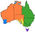
This map shows how Australia is divided. The different colors show where counties, parishes, or hundreds were used.
-
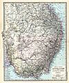
An 1891 German map of southeastern Australia, showing many of the land divisions.


