
Gulf St Vincent facts for kids
Quick facts for kids Gulf St Vincent |
|
|---|---|

Gulf St Vincent is the easternmost of the two inlets
|
|
| Lua error in Module:Location_map at line 420: attempt to index field 'wikibase' (a nil value). | |
| Location | Australia |
| Type | Gulf |
| River sources | Bungala, Dry Creek, Field, Gawler, Gilbert, Light, Little Para River, Onkaparinga, Patawalonga, Port, Sturt, Torrens, Wakefield |
| Basin countries | Australia |
| Max. length | 138.9 km (86.3 mi) |
| Max. width | 61.15 km (38.00 mi) |
| Surface area | 6,800 km2 (2,600 sq mi) |
| Average depth | 21 m (69 ft) |
| Max. depth | 40 m (130 ft) |
| Islands | Garden Island Troubridge Island Torrens Island |
| Settlements | Adelaide |

Gulf St Vincent is a large bay on the southern coast of Australia. It is located in the state of South Australia. This gulf is one of two big water inlets in the area. The other, larger one, is called Spencer Gulf. The Yorke Peninsula separates these two gulfs.
On its eastern side, the gulf is next to the Adelaide Plains and the Fleurieu Peninsula. To the south, its edge runs from Troubridge Point on Yorke Peninsula to Cape Jervis on Fleurieu Peninsula. Water enters the gulf from the southwest through Investigator Strait. It also enters from the southeast through Backstairs Passage. These passages separate the mainland from Kangaroo Island.
Adelaide, the capital city of South Australia, is located right in the middle of the gulf's eastern shore. Other towns along the gulf include Edithburgh, Port Vincent, Ardrossan, Port Wakefield, and Normanville.
The Aboriginal people who originally lived in this area are the Kaurna people. They called this gulf Wongajerla. This name can also be spelled Wongga Yerlo or Wonggayerlo. It means "western sea."
History of Gulf St Vincent
The Gulf St Vincent was first named by Matthew Flinders. He explored the area on March 30, 1802. Flinders called it Gulph of St. Vincent. He chose this name to honor Admiral John Jervis. Admiral Jervis had won an important naval battle near Cape St. Vincent in Portugal.
Soon after Flinders, another explorer named Nicolas Baudin mapped the gulf. Baudin named it Golfe de la Mauvaise or Golfe de la Misanthrophie. The next year, in 1803, Louis de Freycinet renamed it again. He called it Golphe Josephine to honor Josephine Bonaparte.
Flinders was held prisoner for a long time on Mauritius while returning to England. Because of this, Baudin's map was published three years before Flinders' own map.
The Adelaide Desalination Plant is located on the eastern shore of Gulf St Vincent. It is in a place called Lonsdale. This plant takes salty water from the gulf and turns it into fresh drinking water. It supplies water to the city of Adelaide. The plant officially opened in 2013.
Marine Life in the Gulf
The Gulf St Vincent is full of interesting sea creatures. You can find many types of crustacea, like crabs and prawns. There are also many polychaetes, which are a type of segmented worm.
Other animals living in the gulf include different kinds of sea squirts and sea urchins. The bottom of the gulf is mostly soft mud and sand. Near the mouth of the Port River, you can find areas with zosteraceae, which are a type of seagrass.
A type of cardinalfish called Vincentia was named after Gulf St Vincent. This is because the first example of this fish was found and studied here.
Gallery
-

A seahorse swimming beneath Edithburgh Jetty.
-
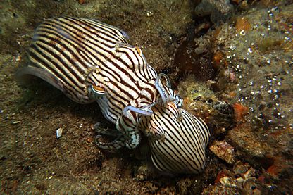
Two striped Pyjama squid mating under Edithburgh jetty.
-

A hermit crab hiding beneath Edithburgh jetty.
-
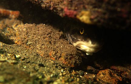
A Rock ling fish seen beneath Edithburgh jetty.


See also
 In Spanish: Golfo Saint Vincent para niños
