Adelaide Plains facts for kids
Quick facts for kids Adelaide PlainsSouth Australia |
|
|---|---|

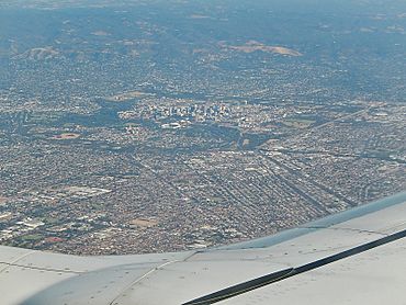
Aerial view of the Adelaide metropolitan area viewed from above the northern suburbs at the bottom of the image. The city centre is the cluster of buildings in the centre, the Adelaide Hills are centre-right, the eastern suburbs on the far left and the southern suburbs far centre.
|
|

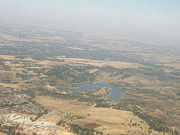
Northwest regions of the Adelaide Plains. The built-up area in the bottom left corner is Greenwith. The dark dotted areas in the background are the northern suburbs of Adelaide, corresponding to the City of Playford centred around Elizabeth and the mid-area of the Adelaide Plains are further in the background.
|
|
The Adelaide Plains is a flat area of land in South Australia. Its traditional name in the Kaurna language is Tarndanya. This plain stretches from the coast, called Gulf St Vincent, on its western side, all the way to the Mount Lofty Ranges in the east. The southern part of the plains reaches the seaside suburbs of Adelaide, near Brighton. To the north, the plains extend roughly to the Hummocks Range and the Wakefield River.
Contents
Rivers and Waterways
The Kaurna people, who are the traditional owners, have lived on the Adelaide Plains for a very long time. Many rivers and creeks flow across these plains. However, some of these waterways dry up during the hot summer months.
The main rivers, listed from south to north, include:
- The Onkaparinga River, also known as Ngangki
- The Sturt River, also known as Warri
- The River Torrens, also known as Karra Wirra
- The Little Para River
- The Gawler River
- The Light River, also known as Yarralinka
- The Wakefield River, also known as Undalya
Different Parts of the Plains
The Adelaide Plains can be thought of as having three main sections. Each section is used for different things.
Southern Area: Adelaide City
The southern part of the plains is where the city of Adelaide is located. Adelaide is the capital city of South Australia. This area is now mostly covered by buildings, roads, and homes.
Central Area: Food Production
The middle part of the Adelaide Plains is very important for growing food. It is sometimes called the "breadbasket" of South Australia. You will find many market gardens here, where fresh vegetables are grown. There are also many wineries, especially around the towns of Virginia and Angle Vale.
Northern Area: Farming
The northern part of the plains is mainly used for larger-scale farming. Farmers here grow important crops like wheat, barley, and canola. This area is also used for raising sheep.
What "Adelaide Plains" Means
Sometimes, when people say "Adelaide Plains," they are talking about a specific part of the area. This usually refers to the central and northern parts, which are outside the main city. For example, the Adelaide Plains Council is a local government area. It covers about 932 square kilometers of the plains. This area stretches from the Gawler River in the south up to places like Wild Horse Plains, Long Plains, and Grace Plains, which are north of Dublin and Mallala.
 | Aaron Henry |
 | T. R. M. Howard |
 | Jesse Jackson |


