Little Para River facts for kids
Quick facts for kids Little Para |
|
|---|---|

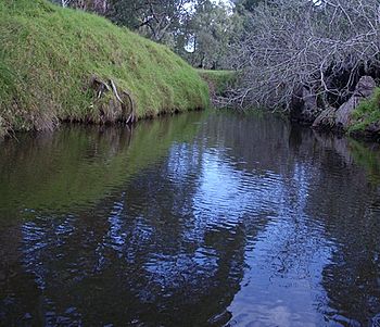
Little Para River, Carisbrooke Reserve, Salisbury Park
|
|
|
Location of the river mouth in South Australia
|
|
| Country | Australia |
| State | South Australia |
| Region | Adelaide Plains |
| Physical characteristics | |
| Main source | Mount Lofty Ranges near Lower Hermitage 284 m (932 ft) |
| River mouth | Gulf St Vincent Globe Derby Park 0 m (0 ft) 34°46′S 138°36′E / 34.767°S 138.600°E |
| Length | 29 km (18 mi) |
| Basin features | |
| Reservoir | Little Para Reservoir |
The Little Para River is a creek in South Australia. It flows across the Adelaide Plains. This river helps fill reservoirs. These reservoirs provide water for homes in northern Adelaide.
Contents
River's Journey and Features
The Little Para River starts in the Mount Lofty Ranges. It flows from near Lower Hermitage. The river then goes northwest to the Little Para Reservoir. After that, it flows west towards the Gulf St Vincent. It reaches the Gulf at Globe Derby Park. The river travels about 29-kilometre (18 mi). It drops 279 metres (915 ft) from its start to its end.
River's Health and Environment
The upper part of the river has many different plants and animals. This is called biodiversity. But the lower part is affected by people and stormwater (rainwater runoff). This runoff can carry pollution into the river.
How the River Shaped the Land
As the river flows from the Adelaide Hills, it crosses a natural step in the land. This step is called an escarpment. It is caused by a geological fault. Over time, the river has dropped sand and gravel. This created a large fan-shaped area called an alluvial fan. The city of Salisbury is built on this fan.
Controlling Floods and Storing Water
The river used to be narrow and winding. It would often flood during heavy rains. It also rarely reached the sea. To stop flooding, the river has been made wider. Walls called levees were also built along its banks.
In the 1800s, people dug wells because the river flow was not steady. The Little Para River helps refill these wells. The water in the wells is held in layers of clay, sand, and gravel. These layers can be up to 61 metres (200 ft) deep.
The Little Para Reservoir was built on the river. It helps store water and control floods. The river's own water is not enough to fill the reservoir. So, water is also pumped into it from the Murray River. Sometimes, water is let out of the reservoir into the river. This helps to refresh the groundwater (water found underground).
What's in a Name?
The name Para comes from the Kaurna language. The Kaurna people are the traditional owners of this land. In their language, pari means "river." The word "Little" was added to tell it apart from the North Para River and South Para River. These two rivers join to form the Gawler River. The Gawler River is about 16 km (9.9 mi) north of the Little Para.
A Look Back in Time
In 1838, a man named John Barton Hack bought a large piece of land nearby. It was 1,600-hectare (4,000-acre) and cost £1 per acre. Hack started a dairy farm there. He would transport butter south to the city of Adelaide.
The Little Para River also attracted John Harvey. He started the settlement of Salisbury in 1847. The river was very important for growing citrus fruits like oranges. This industry began in 1852.
In the 1960s, the City of Salisbury started buying land along the river. They wanted to create public spaces. Now, there is a belt of parklands along the river. These parks have trails for biking and walking.
 | Kyle Baker |
 | Joseph Yoakum |
 | Laura Wheeler Waring |
 | Henry Ossawa Tanner |


