
River Torrens facts for kids
Quick facts for kids Torrens |
|
|---|---|

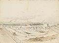
View of Elder Park, the Riverside Precinct and the Torrens Lake, before construction of the pedestrian bridge in 2014.
|
|

Torrens catchment, creeks and reservoirs
|
|

Location of the river mouth in South Australia
|
|
| Native name | Karrawirraparri, Tandanyaparri |
| Other name(s) | Karrawirra Parri |
| Country | Australia |
| State | South Australia |
| Region | Adelaide Plains |
| Physical characteristics | |
| Main source | Mount Lofty Ranges Mount Pleasant 480 m (1,570 ft) |
| River mouth | Gulf St Vincent Henley Beach South 0 m (0 ft) 34°55′S 138°36′E / 34.917°S 138.600°E |
| Length | 85 km (53 mi) |
| Width |
|
| Basin features | |
| Basin size | 508 km2 (196 sq mi) |
| Reservoir | Kangaroo Creek Reservoir |

The River Torrens is the most important river on the Adelaide Plains in South Australia. It was a key reason why the city of Adelaide was built where it is. The river flows for 85 kilometres (53 mi) from its start in the Adelaide Hills near Mount Pleasant. It then goes across the Adelaide Plains, past the city centre, and finally flows into Gulf St Vincent near Henley Beach South and West Beach. The upper parts of the river and the dams in its watershed provide a lot of the city's water supply.
The river also has a native name from the Kaurna language: Karrawirra Parri or Karrawirraparri. This name means "redgum forest river" because karra means redgum, wirra means forest, and parri means river. This name was officially added in 2001. Another Kaurna name for the river was Tarndaparri, meaning "Kangaroo river". The Kaurna people believed the river was a reflection of the Milky Way and was very important to them. They lived along its banks and near its smaller creeks.
In 1836, when William Light explored the area, he chose a bend in the river as the perfect spot for the Adelaide city centre and North Adelaide. The river was first called "The Yatala" by the explorers. But it was later renamed to honor Robert Torrens senior. He was the head of the group that helped set up the colony of South Australia. Early settlers used the river for water. But they also used it as a sewer, which caused outbreaks of typhoid.
Over the years, the River Torrens has become a popular tourist attraction. Its long linear parks and a created lake are famous parts of the city. People have changed the river's plants and animals a lot since European settlement. In the 1800s, native forests were cut down, and many foreign plants and animals were brought in. Now, many native plants are being replanted, and introduced species are being controlled.
The river and its smaller creeks have very different water flows. They can be raging floods that damage bridges and flood cities. Or they can be just trickles, or even completely dry in summer. To stop winter and spring floods, special flood control projects have been built. These include a created outlet to the sea, landscaped parks, and three large dams.
Contents
How the River Torrens Was Formed
The River Torrens flows mostly west from the Adelaide Hills through the middle of Adelaide to the Gulf St Vincent. It starts near Mount Pleasant, about 480 metres (1,575 ft) above sea level. The river follows fault lines in the ground. These faults were formed millions of years ago.
From its start to Birdwood, the river flows through gentle, flat land. Then it enters a hilly area that continues to Gumeracha. After Cudlee Creek, the river flows through a deep gorge. It continues through the gorge to Athelstone. After the hills, it flows over different types of rocks. This has created narrow and wide parts of the river. From the bottom of the Adelaide Hills to Adelaide's city center, it flows in a shallow valley. The river used to flow into Gulf St Vincent through the Port River. But over time, the Torrens dropped too much sediment. This blocked its path to the sea. It then formed swampy areas like the Cowandilla Plains and The Reedbeds.
River Torrens' Tributaries
Many smaller creeks feed the Torrens. These creeks are usually dry for most of the year in their lower parts. But they can flood during winter and spring. There are five main creeks that join the river from the south side as it crosses the Adelaide Plains. There are also at least five more in the Adelaide Hills.
The creeks on the plains are called First to Fifth Creeks. First Creek is the most southerly, and the others are numbered northwards. They used to have different names, including Kaurna names.
Many of these creeks have been changed a lot. Some parts are now concrete channels. Others flow through gardens or even underground pipes. Most of the original plants have disappeared from these creeks. New plants like olives and bamboo have taken over. There is a risk of flooding from these eastern suburbs creeks.

- First Creek starts in Cleland Wildlife Park on the western side of Mount Lofty. It flows northwest through the southeastern suburbs. It passes the Waterfall Gully falls and through Hazelwood and Tusmore Parks. It then joins the Torrens near Adelaide Zoo. Much of it flows underground. Some of its water is used to create the First Creek Wetland in the Adelaide Botanic Garden. This helps to provide water and encourage different plants and animals. Botanic Creek flows through the eastern Adelaide parklands into the Adelaide Botanic Garden before joining First Creek.
- Second Creek starts in the Summertown area of the Adelaide Hills. It flows through Greenhill and into the suburbs. It passes through Michael Perry Reserve in Burnside and then through Erindale, Marryatville, and Norwood. Much of it is underground. The part in St Peters is an open canal before it joins the Torrens. Stonyfell Creek flows through Kensington Gardens and joins Second Creek near Magill and Portrush Roads.
- Third Creek starts near Norton Summit. It flows through Magill, Tranmere, Trinity Gardens, and Payneham. Most of it is underground before it joins the Torrens at Felixstow.
- Fourth Creek, also called Morialta Creek, starts on the other side of Norton Summit. It is famous for its waterfalls in Morialta Conservation Park. "Moriatta" is a Kaurna word meaning "ever flowing". This name is now official for Fourth Creek.
- Fifth Creek also starts within the Morialta Conservation Park. It flows alongside Montacute Road and joins the Torrens at Athelstone.
The largest creek that feeds the Torrens is Sixth Creek in the Adelaide Hills. It joins the Torrens at Castambul on Gorge Road.
How Water Flows in the River Torrens

When Europeans first arrived, the river was a series of waterholes in summer. These were surrounded by large gum trees. In some places, the river was hidden under its gravel stream bed. It often flooded in winter. But it did not reach the sea. Instead, it ended at coastal dunes, forming large, shallow wetlands. These wetlands were called The Reedbeds.
The river only flowed to the sea through the Port River, Barker Inlet, and Patawalonga River after very heavy rain.
The river's catchment area is about 500 km2 (193 sq mi). This is the largest for any waterway in the Adelaide area. The upper parts of the river are used to provide drinking water for Adelaide. The river supplies three of Adelaide's eight dams. The upper catchment gets a lot of rain each year. The Torrens has a very changeable flow. It can quickly change from a trickle to a flood. This caused problems for early settlers building bridges.
The river has flooded many times since settlement, sometimes causing big problems. Adelaide's western suburbs were especially likely to flood. As Adelaide grew, less rain was needed to cause floods, and the damage increased. More stormwater runoff and changes to the riverbanks made the problem worse.
To control floods, the Breakout Creek (also called Breakout Channel) was built. This channel takes the Torrens westwards to the sea. It was completed in 1937. The old channel was blocked, and the new one was created. This also helped drain the reedbeds and swamps. Some of that area is now the suburb of West Lakes.

Work also began in the 1960s on the Kangaroo Creek Reservoir. It opened in 1969. This is the only dam directly on the river. The "River Torrens Committee" was formed in 1964. Its job was to help protect the river's beauty and develop it for fun activities.
Torrens Lake

The Torrens Lake was created in 1881. A weir was built, and Elder Park was landscaped. The lake is now a central part of many Adelaide events and famous pictures. Elder Park, with its iron rotunda, opened in 1882.
In 1867, prisoners from Adelaide Gaol built a wooden dam. But it was poorly built and washed away by the Torrens. A permanent concrete weir was started in 1880 and finished in 1881. The gates were closed to fill the Torrens Lake on July 1, 1881. About 40,000 people, almost all of Adelaide's population, came to the official opening. The weir was rebuilt from 1928 to 1929. Now, its gates can be fully raised to let the river flow freely.


The "Popeye" boats are private ferries that operate on the lake. They travel between Elder Park and the Adelaide Zoo. The first Popeye boat was launched in 1935. It was built to hold 20 passengers. Over the years, more Popeye boats were added. Trips on the Popeyes became a popular family outing. In 1977, Popeye 5 even carried Queen Elizabeth II and Prince Philip! New fiberglass Popeye boats replaced the old wooden ones in 1982.
Water Use and Quality
In Adelaide's early days, the Torrens was used for bathing, watering animals, and getting rid of rubbish. It was also used for water supply and as a sewer. This caused many health problems. In 1839, after a dysentery outbreak, Governor Gawler banned bathing and dumping animal waste in the river near town.
The "Waterworks Act" of 1856 allowed for dams to be built upstream on the Torrens for water supply. The first attempt at a weir failed. But in 1859, a new weir and reservoir were built at Thorndon Park. By 1860, piped water was supplied to citizens. By 1872, the Hope Valley Reservoir was completed.
Public baths were built in 1861 near Parliament House. They used water from the Torrens. These baths were later upgraded but were torn down in 1970. The Millbrook Reservoir was built from 1913 to 1918. It is fed by a tunnel from a weir on the river at Gumeracha.
Today, the Hope Valley, Millbrook, and Kangaroo Creek Reservoirs store the river's water. These reservoirs provide 60% of Adelaide's water needs. The Adelaide City Council uses water from the lower river to water the city's parklands. Rubbish is collected, and pollutants are filtered through special wetlands.
However, the lower river, especially the lake, can still be polluted. This is due to limited natural flow and organic material from stormwater. This can cause algal blooms and high levels of E. coli bacteria in spring and summer. Groups have been formed to improve the river's water quality.
Bridges Over the Torrens
Because the river flows through the center of Adelaide, many bridges were needed. Before bridges, people crossed using fords, which were dangerous in winter. The first timber bridge was built in 1839 but was destroyed by floods in 1844. Over the years, many bridges have been built and rebuilt. Here are some of the bridges, listed from upstream to downstream:
| Location | Bridge Name | Image | What it is and how it's used | |
|---|---|---|---|---|
| Mount Pleasant | Carries Cricks Mills Road (B35) |
|||
| Birdwood | Carries Warren Road (B34) |
|||
| Gumeracha | Carries Forreston Road | |||
| Carries Torrens Valley Road (B10) |
||||
| Carries Gorge Road (T58) |
||||
| Cudlee Creek | Carries Gorge Road (T58) |
|||
| Carries Gorge Road (B31) (T58) |
||||
| Carries Gorge Road (B31) (T58) |
||||
| Paracombe | Carries Gorge Road (B31) (T58) |
|||
| Highbury | ||||
| Dernancourt | Carries Lower North East Road (A11) |
|||
| Carries Northeast Busway | ||||
| Paradise | Dickson's Crossing | Built in 1977 for Darley Road; replaced an earlier ford. | ||
| Windsor Gardens | ||||
| Klemzig | ||||
| Carries Northeast Busway | ||||
| Carries Riverside Drive | ||||
| Marden | Felixstow Bridge | Built in 1873 for OG Road. It has been rebuilt several times. | ||
| Klemzig | Carries Northeast Busway | |||
| Vale Park | Ascot Bridge | Built in 1970 for Ascot Avenue (A17) |
||
| Marden | Carries Northeast Busway | |||
| Royston Park | Carries Northeast Busway | |||
| Walkerville | Carries Northeast Busway | |||
| Carries Northeast Busway | ||||
| St Peters | Carries Northeast Busway | |||
| Gilberton | Tennyson Bridge | Built 1877 for Stephen Terrace, replacing a ford. | ||
| Carries Northeast Busway | ||||
| Swing Bridge | Carries Swing Bridge Lane | |||
| St Peters | Carries Northeast Busway | |||
| Gilberton | Carries Shared Park | |||
| Hackney | Hackney Bridge | First built by a company for wheat farmers. The current bridge is the third at this spot, built in 1885. It carries Hackney Road (A21) |
||
| Adelaide | Torrens River Park Pedestrian Bridge | Opened in 2009, east of the zoo. Popular with cyclists. | ||
| Albert Bridge | Next to the Adelaide Zoo, carries Frome Road. Named after Prince Albert in 1879. Made of wrought iron from England. It is 36.6 metres (120 ft) long. The bridge is listed as a heritage site. | |||
| University Footbridge | Connects Victoria Drive with University Oval. Designed by university staff and built in 1937. It was the first welded bridge in South Australia. | |||
| City Bridge | Opened in 1856, extending King William Street to North Adelaide. Replaced in 1931 with a new concrete arch bridge. | |||
| Adelaide Oval Footbridge | ||||
| North Adelaide | Victoria Bridge | Extends from Morphett Street, crossing rail lines and the river. The current bridge opened in 1968. It was designed without a central pillar in the river so rowers could compete easily. | ||
| Railway Bridge | Built in 1856 for the Port and Gawler Town railway lines. | |||
| Thebarton | Hindmarsh Bridge | Carries Port Road (A21) |
||
| Hindmarsh | Sir William Goodman Bridge | Built in 1909 for trams. It was later used by buses and then general traffic. Closed in 1990 due to age. Restored and reopened in 2014 for walkers and cyclists. It was the first reinforced concrete bridge in Adelaide. | ||
| Thebarton | Taylors Bridge | Carries South Road (A13) |
||
| Torrensville | Carries McDonnell Avenue | |||
| Underdale | Holbrooks Bridge | Carries Holbrooks Road (A14) |
||
| Flinders Park | Keele Bridge | Carries Rowells Road (south)/Findon Road (north) | ||
| Lockleys | Kidman Bridge | Carries Henley Beach Road | ||
| Fulham | Davis Bridge | Carries Tapleys Hill Road | ||
| West Beach | Seaview Road Bridge | Carries Seaview Road |


.jpg)


River Torrens: Plants and Animals
The River Torrens used to be a source of food. It had yabbies, mussels, and small fish. But water quality has gone down, and new fish species have been introduced. This has led to fewer native fish. Foreign pest species like European carp have greatly reduced native fish. However, native waterfowl are common. You can see Pacific black ducks, Australian wood ducks, black swans, ibis, egrets, and herons. There are more than 100 bird species.
The river and its creeks used to have water rats and Australian swamp rats. Water rats are still there but in smaller numbers. Introduced black rats and brown rats have largely replaced the native ones. The house mouse is now the most common mammal around the Torrens.
Many native plants grow along the upper river. These include bulrush, common reed, and different types of rushes. River red gum and blue gum trees grow along the riverbanks. These trees were much denser before settlers cleared them. Other native plants still present are Sheoak, native cherry, native pine, and Australia's floral emblem, the golden wattle.
The River Torrens Today
From its start, the river flows west through Birdwood and Gumeracha. It then goes through Torrens Gorge and enters suburban Adelaide at Athelstone. Part of its path runs next to the O-Bahn Busway. It flows between the city-centre and North Adelaide. The Torrens Lake is formed between the Adelaide Zoo and a weir near Adelaide Gaol. The river then continues for about eight kilometers to the sea at Henley Beach South. It empties into Gulf St Vincent through a special outlet.
Hope Valley, Millbrook, and Kangaroo Creek Reservoirs store the river's water. These dams are part of the Adelaide Hills catchment. They provide 60% of Adelaide's water in an average year. The Adelaide City Council uses water from the lower river to water the city's surrounding parklands. Rubbish in the lower river is controlled with collection racks. Sediments and other pollutants are filtered through built wetlands.

Australia's first linear river park runs along the suburban end of the river. This park is 35 kilometres (22 mi) long. It has many playgrounds, walkways, and bicycle tracks. On the south bank of the lake, next to the Adelaide Festival Centre, Elder Park is used for many public events. These include the annual Tasting Australia festival and "Carols by Candlelight". The Popeye tourist boats, small paddle boats, and Black Swans on the lake are famous symbols of the city.
Many people use the river for fun activities. The paths along the riverbanks are often full of cyclists and joggers. Rowers train on the lake all year. Many clubs, like the Adelaide University Boat Club and the Adelaide Rowing Club, are located on its banks. High schools also have boathouses there. Several rowing races are held on the Torrens Lake each year.
Images for kids
-
North Terrace Adelaide and the Torrens, 10 August 1888, Henry Grant Lloyd
-

Adelaide Oval Footbridge over the Torrens
-
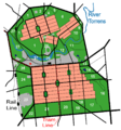
The river's path flowing between Adelaide and North Adelaide, through Adelaide's parklands


See also
 In Spanish: Río Torrens para niños
