
Thebarton, South Australia facts for kids
Quick facts for kids ThebartonAdelaide, South Australia |
|||||||||||||||
|---|---|---|---|---|---|---|---|---|---|---|---|---|---|---|---|

Queen of Angels Roman Catholic church on the corner of South Road and Kintore Street
|
|||||||||||||||
| Established | 1839 | ||||||||||||||
| Postcode(s) | 5031 | ||||||||||||||
| Location | 2 km (1 mi) W of Adelaide | ||||||||||||||
| LGA(s) | City of West Torrens | ||||||||||||||
| State electorate(s) | West Torrens | ||||||||||||||
| Federal Division(s) | Adelaide | ||||||||||||||
|
|||||||||||||||
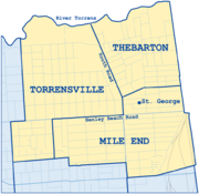
Thebarton is a suburb located just west of Adelaide, South Australia. It sits on land that originally belonged to the Kaurna people.
The suburb is surrounded by the River Torrens to the north, Port Road and Bonython Park to the east, Kintore Street to the south, and South Road to the west.
Many places that have "Thebarton" in their name, like the Thebarton Oval and Thebarton Senior College, were once part of a larger area called the Town of Thebarton. This older area also included much of the nearby suburb of Torrensville. Even the historic Adelaide Gaol and the Thebarton Barracks (for the South Australia Police) are actually located in the Adelaide Park Lands, just outside Thebarton's current boundaries.
Some parts of Thebarton used to have different names, such as Southwark, Hemmington, Hemmington West, and West Thebarton.
Contents
The History of Thebarton
How Thebarton Got Its Name
Before European settlers arrived in South Australia, the Kaurna people called this area Karraundongga. This name means "red gum spear place" because they would gather branches from red gum trees along the River Torrens to make spears.
The suburb of Thebarton was named after the home of Colonel William Light. He was the first Surveyor-General of the new colony of South Australia. Colonel Light named his home "Theberton Cottage" after "Theberton Hall" in England, where he went to school. The area was known as Theberton until around 1840. The change to "Thebarton" is thought to be a simple spelling mistake, not a change based on old English words.
Colonel Light surveyed this area as Section 1 and built his cottage in the northern part. The land was first divided for houses in February 1839. However, it took a few years for people to build homes there. The Thebarton Post Office opened on 24 October 1850. By 1866, about 450 people lived in the area.
Thebarton's Old Racecourse and Town Hall
An old racecourse, called Thebarton Racecourse, operated in the area from 1838 to 1869. It was on land now known as Mile End. This land was later divided and built over.
The original Thebarton Town Hall was built in 1885. It was designed by Alfred Wells and Latham Withall. Sadly, a fire destroyed the inside of the building in 1948. Its rebuilding was later described as "thoroughly horrible" by some.
The Famous Southwark Brewery
The Torrenside Brewery started in 1886 on Port Road, in what was then the suburb of Southwark. It later became part of the South Australian Brewing Company in 1939. In 1949, it was renamed Southwark Brewery, and their popular beer became "Southwark beer."
The brewery closed its doors on 17 June 2021. Its tall chimney tower is a heritage-listed landmark, meaning it will be protected even as the site is redeveloped. Items from the brewery's museum are being given to the State Library of South Australia and other local places.
Who Lives in Thebarton?
Thebarton has a large Greek-Australian population. It's actually the suburb in Australia with the most Greek-Australians compared to its total population. In 2001, Thebarton and its neighbor Torrensville together were home to 4,471 Greek-Australians. This made up 18.7% of their total population.
-
One of the three suburbs in West Torrens with a high population of Greek-Australians

What Can You Find in Thebarton?
University Campus
The Thebarton campus of the University of Adelaide is located here. It's also known as the Adelaide University Research Park. This campus uses a group of old industrial buildings in the northeastern part of the suburb.
-
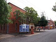
Stirling Street entrance to the University of Adelaide's Thebarton Campus

Important Places and Landmarks
- St George Greek Orthodox Church on Rose Street is Adelaide's largest Greek Orthodox church.
- The Ice Arena is where the Adelaide Adrenalines ice hockey team plays in the Australian Ice Hockey League.
- Thebarton Oval used to be the home of the West Torrens Football Club. Now, it's home to the Adelaide Footy League.
- The Thebarton Incinerator on West Thebarton Road was designed by the famous architect Walter Burley Griffin in 1935. It was finished in 1937 but stopped being used in 1964. It's one of only two buildings in South Australia designed by Burley Griffin that are considered nationally important.
- The West End Brewery at 107 Port Road closed in June 2021.
- The well-known Thebarton Theatre was originally built as the town hall. It is actually in the nearby suburb of Torrensville.
- The Adelaide Gaol is just east of Thebarton, in the western Adelaide parklands.
- A special memorial for Maria Gandy, who was Colonel William Light's partner, stands on the corner of Albert and Maria Streets. It was unveiled in 2011 to celebrate her 200th birthday. It honors her roles as a pioneer, settler, carer, and mother.
-
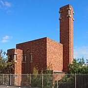
The incinerator at 34 West Thebarton Road was designed by noted American architect Walter Burley Griffin, who designed Canberra. The design, including exquisite tiles detail in this photo, was to mollify the local council, which did not want it within council boundaries.
-
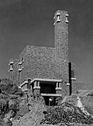
The newly constructed incinerator in 1937. Garbage was tipped in at road level and a reverberatory furnace reduced the garbage to ash, which was fed into this pit to enable the area to be reclaimed.
-
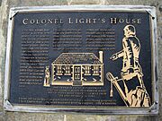
Plaque commemorating Light's "Theberton Hall", demolished 1926. Cast in 1997, its pillar was constructed from remnants of the Hindmarsh Bridge, demolished 1995, and is located across the River Torrens from the site of the Southwark brewery, demolished in the 2020s.
.jpg)
.jpg)

Places with Special Heritage Status
Thebarton has several sites that are listed for their historical importance:
- 39A Dew Street: Lady Gowrie Child Centre
- 1 George Street: Squatters Arms Hotel
- 42 and 42A Phillips Street: Thebarton Baptist Church and Hall
- 77 Port Road: Southwark Hotel
- 107 Port Road, the site of the West End Brewery, has several heritage listings:
- A Plaque marking the Site of Colonel Light's Cottage (from 2001).
- The remains of 'Theberton Hall', Colonel William Light's House, including an underground room, tank, and well (added in 2021).
- The Walkerville Brewhouse Tower, built in 1886, is one of the largest and few remaining examples of a brewhouse tower in South Australia (added in 2021).
- The Electric Supply Company Transformer (from 2001).
- 35-37 Stirling Street: Faulding's Eucalyptus Oil Distillery
- 34-36 West Thebarton Road: Thebarton Incinerator
