Mount Pleasant, South Australia facts for kids
Quick facts for kids Mount PleasantSouth Australia |
|||||||||||||||
|---|---|---|---|---|---|---|---|---|---|---|---|---|---|---|---|

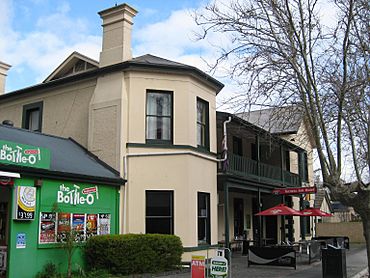
The Totness Inn Hotel on the main street of Mount Pleasant
|
|||||||||||||||
| Established | 1843 | ||||||||||||||
| Postcode(s) | 5235 | ||||||||||||||
| Location | 55 km (34 mi) East of Adelaide via |
||||||||||||||
| LGA(s) |
|
||||||||||||||
| State electorate(s) | Schubert | ||||||||||||||
| Federal Division(s) | Barker | ||||||||||||||
|
|||||||||||||||
Mount Pleasant is a town in South Australia. It is found in the Barossa Council area. This town is just north of the Adelaide Hills region. It is about 55 kilometres (34 miles) east of Adelaide, the state capital.
Mount Pleasant is located in two local government areas: the Barossa Council and the Mid Murray Council. The town sits 440 metres (1,444 feet) above sea level. On average, it gets about 687 millimetres (27 inches) of rain each year.
Contents
History of Mount Pleasant
How the Town Got Its Name
Today, Mount Pleasant is made up of three older areas. These were once separate townships called Totness, Talunga, and Hendryton.
The main Mount Pleasant area was planned by Henry Glover in 1856. It stretched from Railway Terrace to Saleyard Road. The name "Mount Pleasant" came from James Phillis. He arrived from a place in Kent, England, and the land here reminded him of home. His sister was also named Pleasant, which might have helped inspire the name.
Totness was planned in 1858 by Henry Giles Sr. This part of town was from Saleyard Road to Pentelows Road. Henry named it after his wife Mary Ann's birthplace. Later, in 1869, Henry also planned North Totness. This area went from Pentelows Road to Walkers Flat Road.
John Hendry, a blacksmith, lived in Totness. He planned the land west of Mount Pleasant in 1865. This area went from Cricks Mill Road to Railway Terrace.
Early European Settlers
The first European explorers to visit the Mount Pleasant area were Dr. George Imlay and John Hill. They explored the region in January 1838. Settlers began moving into the area in the late 1830s. They brought sheep and bags of grain with them.
One of the first settlers was James Phillis. He arrived in Adelaide in 1839. He rode a horse into the Adelaide Hills to find good land for farming. In 1843, he settled in Mount Pleasant. He grew wheat and then had to take it all the way to Adelaide to sell. With the money he earned, he sailed to England. There, he bought a flock of Romney Marsh sheep. He shipped these sheep back to Mount Pleasant. Over time, James Phillis became a very successful farmer in the area.
Many pioneer families from Mount Pleasant lost sons in World War I. For example, William Polden is buried in The Lone Pine Cemetery at Gallipoli.
A small amount of gold was found in the area in the 1860s. However, there wasn't enough to start big mining operations. Mount Pleasant remained a small town that served the local farms. The original police station from the 1860s has mostly been replaced. Melrose Street, the main street, is lined with plane trees.
Mount Pleasant used to have its own local government, called the District Council of Mount Pleasant. This lasted from 1935 until 1997. Then, it was split between the larger Barossa Council and Mid Murray Council. Today, the town of Mount Pleasant is part of the Barossa Council.
Important Historic Places
Mount Pleasant has several places that are important for their history. These are called heritage-listed sites. They include:
- 'Kent Farm' – 3184 Eden Valley Road: This is a historic cottage and barn from the 1840s.
- 27 Melrose Street: This is the Mount Pleasant Police Station and Cells.
- Walker Flat-Mount Pleasant Road: This is the Rosebank Shearing Shed.
About the Area
Mount Pleasant is located about 10 kilometres (6 miles) north-east of Birdwood. It is on the way to towns like Springton, Eden Valley, and Angaston.
In 2001, a census counted 529 people living in Mount Pleasant. These people lived in 240 homes.
Town Facilities
Mount Pleasant has many useful facilities for its residents. These include:
- A primary school and a kindergarten for younger students.
- A district hospital for medical care.
- A post office for mail services.
- A CFS (Country Fire Service) station to help with fires.
- A butcher shop, two bakeries, and a pharmacy.
- Two pubs for food and drinks.
- Two hairdressers.
- Wilksch's garage and a crash repair shop.
- A golf club, bowling club, and tennis club for sports.
- Showgrounds that host the yearly Mount Pleasant Show.
- A weekly Saturday Farmer's Market where you can buy local produce.
- A caravan park for visitors.
- An RSL (Returned and Services League) club.
- A football club for sports fans.
Getting Around
A bus service runs from Tea Tree Plaza Interchange to Gumeracha and Mount Pleasant. This service is run by Affordable Coachlines. There is also a private bus service that goes from Birdwood to the Barossa Valley through Mount Pleasant.
Mount Pleasant was once the end point of a railway line. This line was part of the South Australian Railways. It branched off the main line from Adelaide to Murray Bridge at Balhannah. The railway line opened on September 16, 1918. However, it closed on March 4, 1963. This was because roads had improved, especially the Adelaide-Mannum Road. The railway tracks were removed soon after.
You can still see parts of the old railway path from some roads. This path is slowly being turned into a trail for cycling, walking, and horseback riding. It is called the Amy Gillett Bikeway. By 2015, this trail had reached Mount Torrens.
 | Anna J. Cooper |
 | Mary McLeod Bethune |
 | Lillie Mae Bradford |


