Palmer, South Australia facts for kids
Quick facts for kids PalmerSouth Australia |
|||||||||||||||
|---|---|---|---|---|---|---|---|---|---|---|---|---|---|---|---|

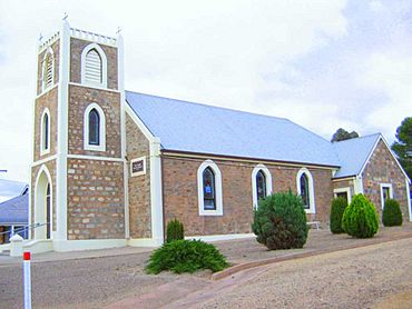
Palmer Lutheran Church
|
|||||||||||||||
| Established | 1860s | ||||||||||||||
| Postcode(s) | 5237 | ||||||||||||||
| LGA(s) | Mid Murray Council | ||||||||||||||
| State electorate(s) | Schubert | ||||||||||||||
| Federal Division(s) | Barker | ||||||||||||||
|
|||||||||||||||
Palmer is a small town located just east of the Adelaide Hills in South Australia. It's about 70 kilometers east-north-east of Adelaide, the state capital. You can find Palmer along the Adelaide-Mannum Road, and it's also about 15 kilometers west-north-west of Mannum. The town is part of the Mid Murray Council, which is its local government area.
Contents
About Palmer
Palmer is a quiet town with a few important places. It has a primary school that first opened its doors in 1882. There's also a general store where you can buy everyday items, a hotel, and a Lutheran Church. The first pastor for the church was Carl Heinrich Loessel, who started his work there on May 22, 1869, even before the church building was finished. Later, Pastor Kuss served the church for a long time.
What You'll Find in Palmer
Besides the school, store, hotel, and church, Palmer is known for some interesting natural features.
Cool Rocks!
If you like unique natural sights, you'll find some cool rock formations at the Granite Boulders Area Geological Site near Palmer. These big rocks are a fun place to explore and see how nature shapes the land.
A Look Back: Palmer's History
Palmer has a rich history, starting long before European settlers arrived.
Early Days and Explorers
The land where Palmer now stands was originally home to the Indigenous Ngaralta people. They lived on these lands for thousands of years. The first European explorers to travel through the Palmer area were Dr George Imlay and John Hill. They explored the region in January 1838.
How Palmer Got Its Name
The area around Palmer was surveyed in 1846. The town itself was officially laid out in August 1873. Palmer was named after Colonel George Palmer. He was a Commissioner for the South Australian Colonisation Commission, which was a group responsible for setting up and managing the new colony of South Australia.
Mining and Farming
When Palmer was first settled, it was important for both mining and farming. A significant discovery was the Kitticoola mine in 1845. This mine had deposits of both copper and gold. Today, the parts of the mine that are still visible above ground are considered heritage sites, meaning they are protected because of their historical importance. In 2014, a company called Hillgrove Resources gained the rights to look for more minerals in the area.
Places with a Story: Heritage Sites
Palmer has several places that are listed as heritage sites. This means they are important historical locations that are preserved for future generations.
- Adelaide-Mannum Road: Granite Boulders Area Geological Site
- Mannum Road: Palmer Police Station and Cells
- off Mine Road: Kitticoola Mine
- Palmer Road: Homestead Complex
- off Western Boundary Road: Reedy Creek Railway Bridge
 | Kyle Baker |
 | Joseph Yoakum |
 | Laura Wheeler Waring |
 | Henry Ossawa Tanner |


