
Romney Marsh facts for kids
Quick facts for kids Romney Marsh |
|
|---|---|

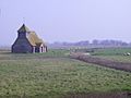
St Mary in the Marsh in Romney Marsh
|
|

Location in Kent
|
|
| Location | Kent, England, UK |
| OS grid | TR053224 |
| Coordinates | 50°58′N 0°55′E / 50.96°N 0.92°E |


Romney Marsh is a special coastal area in southern England. It stretches from Hythe in Kent to Rye in East Sussex. This unique marshland covers about 100 square miles (260 km2).
Romney Marsh is one of England's three main wetlands. The other two are The Fens in East Anglia and the Somerset Levels. Over many centuries, people have worked to drain much of this area. Today, it is mostly flat farmland. Long ago, before it was drained, the wet conditions caused illnesses like malaria among the people living there. For a long time, the Marsh had a lagoon (a shallow body of water) along its edge. A shingle beach at Dymchurch protected this lagoon.
Even now, the Marsh has important water features. These include the Royal Military Canal, which was finished in 1809, and the River Rother.
Contents
What is Romney Marsh?
Romney Marsh is a low-lying area that was once mostly under the sea. Over thousands of years, the sea slowly pulled back. This left behind layers of mud, sand, and shingle (small, rounded stones). This process created the flat land we see today.
How the Marsh Changed Over Time
For a long time, the Marsh was a wild, wet place. People started to drain parts of it to make it useful for farming. They built dykes (ditches) and sea walls to control the water. This hard work turned much of the marsh into rich pasture land.
History of Romney Marsh
Romney Marsh has a long and interesting history. Because it's so close to France, it was often a place where invaders tried to land.
Early Invasions and Settlements
In AD 892, a large Danish fleet of 250 ships sailed right into the River Rother. They attacked and destroyed a fortress at Appledore. Some stories say this fortress was built by the legendary King Arthur!
The Romans also used the Romney area. They had a salt industry here. They would leave pans of salty water to evaporate in the sun. Then, they collected the salt left behind. Salt was very important for preserving food in ancient times.
Ancient Towns and Ports
The Marsh is home to two of the ancient Cinque Ports. These were important coastal towns that helped protect England. They are New Romney and Hythe. Two other old towns, Rye and Winchelsea, are also nearby.
New Romney was once a busy port, right on the sea. But over time, the coastline changed. Now, New Romney is about a mile and a half away from the sea. It is the biggest town and main center of people living on the Marsh today.
Life on the Marsh Today
Today, Romney Marsh is known for its wide-open spaces and unique wildlife. It's a great place for nature lovers and those who enjoy quiet walks.
Farming and Nature
The flat farmland is perfect for raising sheep. You'll see many sheep grazing in the fields. The dykes and ditches that crisscross the Marsh are home to many different plants and animals. They provide important habitats for birds, insects, and fish.
Exploring the Marsh
There are many footpaths and cycle routes across the Marsh. These paths let you explore the unique landscape. You can see old churches, small villages, and the famous "looker's huts." These small huts were used by shepherds to watch over their sheep.
The Romney, Hythe and Dymchurch Railway is a popular attraction. It's a miniature steam railway that runs across the Marsh. It connects the towns of Hythe, Dymchurch, St Mary's Bay, New Romney, and Dungeness. It's a fun way to see the area!
Images for kids
-
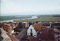
View across the marsh from Rye
-

View across the marsh from just outside Dymchurch
-
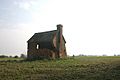
A looker's hut near Brenzett in 2007
-
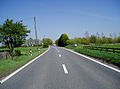
A view along the A259 just outside Brookland, Kent
-
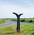
A National Cycle Network signpost on Romney Marsh, indicating Folkestone to the left and Rye to the right
-
St Thomas à Becket church, Fairfield
-
The ruins of Midley Church


