
East Anglia facts for kids
Quick facts for kids
East Anglia
|
||
|---|---|---|
|
Region
|
||
|
||
| Etymology: Kingdom of the East Angles | ||

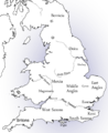
East Anglia: with the ceremonial counties of Norfolk and Suffolk (in red) to the north and south and Cambridgeshire and Essex (in pink) to the west
|
||
| Sovereign state | United Kingdom | |
| Country | England | |
| Region | East of England | |
| Ceremonial counties |
|
|

East Anglia is a special area in the East of England. It includes the counties of Norfolk, Suffolk, and Cambridgeshire. Sometimes, parts of Essex are also considered to be in East Anglia. The name comes from an old Anglo-Saxon kingdom called the East Angles. These people originally came from a place called Anglia in what is now Northern Germany.
Contents
What is East Anglia?
The exact area of East Anglia can change depending on who you ask!
The Original Kingdom
The Kingdom of East Anglia was set up by the Anglo-Saxons in the 500s. It first included Norfolk and Suffolk. Later, it grew west into parts of Cambridgeshire, especially the marshy areas known as The Fens.
Modern Definitions of East Anglia
Today, for official statistics, East Anglia includes Norfolk, Suffolk, and Cambridgeshire (with the City of Peterborough). These three counties also form the Roman Catholic Diocese of East Anglia since 1976.
Some people also include Essex in East Anglia. Even though the Kingdom of Essex was separate and its people were Saxons, not Angles, many people in northern Essex feel they are East Anglian. For example, the football team Colchester United F.C. competes for the "Pride of Anglia" title. Culturally, northern Essex feels more like Suffolk because of its similar countryside.
Other ideas for East Anglia have been suggested. In 1969, a report suggested a larger East Anglia that would include northern Essex, southern Lincolnshire, and a small part of Northamptonshire, along with Cambridgeshire, Norfolk, and Suffolk.
Towns like Ely and St Neots in Cambridgeshire are sometimes called the "gateway" to East Anglia.
Growing Cities in East Anglia
Cities like Peterborough and Cambridge in East Anglia are among the fastest-growing in the UK. They are growing in both population and economy. The whole East of England region, including East Anglia, has the fastest population growth in the country.
The biggest city and urban area in East Anglia is Peterborough. In 2021, it had an urban population of about 215,673 people.
History of East Anglia
East Anglia has a rich and interesting history.
Early Beginnings
The Kingdom of East Anglia started around 520 AD. It was formed by joining the "North Folk" and "South Folk" (two groups of Angles) who had settled in the lands of the ancient Iceni tribe. It was one of the main Anglo-Saxon kingdoms in England, as written by Henry of Huntingdon in the 1100s. Many experts believe that a lot of Germanic people settled here very early on.
Genetic Links to the Past
A study in 2016 found that people in East Anglia today have a lot of shared genes with early medieval skeletons. However, their genes are quite different from people who lived in the Iron Age and Roman times. This suggests that the Anglian migrations had a big impact on the genes of people in East Anglia. Another study in 2022 showed that people in Norfolk and Suffolk have the lowest amount of ancient British Isles ancestry and the highest amount of ancestry from Northern and Western Europe.
A Powerful Kingdom (for a short time!)
East Anglia was the most powerful Anglo-Saxon kingdom for a short time around 616 AD. Its King Rædwald was even a "Bretwalda," meaning he was an overlord of other Anglo-Saxon kingdoms. But this didn't last. The Mercians defeated East Anglia twice, and the kingdom became weaker.
In 794, Offa of Mercia had King Æthelberht killed and took control. East Anglia became independent again in 825, but the Danes killed King Edmund in 869 and captured the kingdom. Later, Edward the Elder made East Anglia part of the Kingdom of England.
Changes to the Land and People
Until the 1600s, much of East Anglia was marshland, especially the Fens. Dutch-style drainage projects turned this wet land into rich farmland. In the 1630s, thousands of Puritan families from East Anglia moved to New England in America. They took much of their East Anglian culture with them, which you can still see today.
East Anglia used to be a very rich area, earning money from wool, textiles, and farming. But during the Industrial Revolution, factories and development moved to the Midlands and the North of England.
East Anglia in World War II
During the Second World War, the Royal Air Force and the United States Army Air Force built many airbases in East Anglia. These were used by large bomber planes flying missions against German-occupied Europe. East Anglia was perfect for airfields because it has lots of flat, open land and is close to mainland Europe. Many of these old airfields can still be seen today, and some are still used, like Norwich International Airport.
You can also find old pillboxes (small concrete bunkers) built in 1940 to defend against invasion. Along the coast, there are also Martello towers from the Napoleonic Wars.
Geography of East Anglia
East Anglia has a unique landscape.
Borders and Landscape
East Anglia is surrounded by the North Sea to the north and east. To the south, it's bordered by the estuaries of the Orwell and Stour rivers. To the west, it shares a border with the rest of England.
Much of northern East Anglia is flat, low, and marshy, like the Fens in Cambridgeshire and Norfolk. Even though there's a lot of water, East Anglia is actually the driest part of England because of its low rainfall and drainage projects. Inland, most of Suffolk and Norfolk have gentle rolling hills. The highest point in Norfolk is Beacon Hill at 103 meters (338 feet).
The Wash and Coastline Changes
On the northwest side, East Anglia meets a bay called The Wash. Because of sediment and land reclamation, the coastline here has changed a lot over time. Some towns that were once on the coast, like King's Lynn, are now further inland. On the other hand, the eastern coast facing the North Sea is eroding quickly, so the land has moved significantly inland over the years.
Rivers and Waterways
Important rivers include the River Nene and Suffolk's Stour, which flows through beautiful countryside often painted by John Constable. The River Cam flows through Cambridge, and Norwich is on the River Yare and River Wensum. The River Orwell flows through Ipswich and meets the Stour near Felixstowe.
The Norfolk and Suffolk Broads are a network of waterways between Norwich and the coast. They are very popular for boating and holidays. The Great Ouse river flows into The Wash at King's Lynn.
Major Towns and Cities
The main urban areas in East Anglia are the cities of Norwich, Cambridge, and Peterborough, and the town of Ipswich. Other towns include Bury St Edmunds, Ely, Lowestoft, Great Yarmouth, and King's Lynn. Much of East Anglia is still rural, with many villages surrounded by farmland, breckland, fens, and broads.


.jpg)
Ancient Forests
Thousands of years ago, East Anglia was covered in huge forests. Recent studies found a massive yew forest in the East Anglian Fens about 4,000 years ago. Farmers found over 400 well-preserved yew tree trunks, called 'bog oaks', while ploughing. This shows that a thick native woodland, including oak and yew, covered the Fens back then.
Scientists think this forest died suddenly around 4,200 years ago because the North Sea rose dramatically. This flooded the fens with salt water, killing all the trees. Over time, much of East Anglia's ancient woodland was cleared for farming. By 1086, only about 15% of England was woodland. By 1870, it was less than 5%.
However, some ancient woodlands still exist in East Anglia. These are woods that have been around since at least 1600. Good examples include Thetford Forest, the largest lowland pine forest in Britain, and Hainault Forest in Essex.
Climate in East Anglia
The climate in East Anglia is usually dry and mild. In winter, temperatures are typically 1–10°C, and in summer, 12–25°C. However, temperatures can go much higher or lower than these averages. Even though there are many waterways, East Anglia is one of the driest places in the UK. In summer, the land can become very dry, sometimes leading to field and heath fires. Many areas get less than 700 mm of rain a year, spread fairly evenly. Coastal areas tend to get more sunshine.
Transport in East Anglia
East Anglia has a good network of roads and railways.
Roads
Main roads like the A12 and A47 connect the area to the rest of the UK. The A14 links the Midlands to the Port of Felixstowe. This port is the busiest container port in the UK, handling over 40% of all UK container traffic. There are very few motorways in East Anglia itself.

Railways
The East Anglia franchise covers many of the train lines in the region. Key rail links include the Great Eastern Main Line from Norwich to London Liverpool Street. The West Anglia Main Line connects Cambridge to London. Parts of the East Coast Main Line also run through the area, and Peterborough is an important train station on this line. East Anglia is also connected to the Midlands and northwest England by train.
Cycling and Busways
East Anglia is great for cycling. National Cycle Route 1 passes through the area. Cambridge has the most people cycling to work in the UK, with 25% of its residents commuting by bike. Cambridge also has the Cambridgeshire Guided Busway, which was the longest guided busway in the world when it opened in 2011.
Airports
The only major commercial airport in East Anglia is Norwich Airport. However, London Stansted Airport, one of the busiest airports in the UK, is just south of Cambridge in northern Essex.
Universities in East Anglia
East Anglia is home to some famous universities.
The University of Cambridge, founded in the early 1200s, is East Anglia's most famous university. It is one of the oldest and most well-known universities in the world. Other important universities include the University of East Anglia (in Norwich), University of Essex, Norwich University of the Arts, Anglia Ruskin University (in Cambridge), University of Suffolk (in Ipswich), and University Centre Peterborough.
Enterprise Zones
East Anglia has special "enterprise zones" designed to boost business. The Great Yarmouth and Lowestoft Enterprise Zone was started in 2012. It includes six sites that have attracted many energy-related businesses. There is also an enterprise zone in Cambridgeshire called Alconbury Enterprise Campus in Huntingdon.
Symbols and Culture of East Anglia
East Anglia has its own unique symbols and cultural features.
The Three Crowns Symbol
A shield with three golden crowns on a blue background has been a symbol of East Anglia for hundreds of years. This coat of arms was linked by medieval experts to the Anglo-Saxon Kingdom of East Anglia and its ruling family, the Wuffingas. This symbol looks almost exactly like the coat of arms of Sweden.


You can see the three crowns carved in stone on a baptismal font (around 1400) in Saxmundham church and on the 15th-century porch of Woolpit church, both in Suffolk. They also appear in local symbols and are part of the arms of the diocese of Ely and the town of Bury St Edmunds. In Bury St Edmunds, the crowns have arrows through them to show the death of Edmund the Martyr, the last king of East Anglia. Other groups that use these arms include the former Isle of Ely County Council and the University of East Anglia. The flag of Cambridgeshire (adopted in 2015) also includes the three gold crowns on a blue background.
The East Anglian flag we know today has the three crowns on a blue shield over a St George's cross. It was suggested in 1902 and adopted by the London Society of East Anglians.
East Anglia in Literature
East Anglia is often featured in English books. For example, Noël Coward's play Private Lives and Graham Swift's novel Waterland are set here. The area also appears in works by L.P. Hartley, Arthur Ransome, Dorothy L. Sayers, and M.R. James. James grew up in Suffolk and used the area as the setting for some of his famous ghost stories, like "A Warning to the Curious."
Suffolk Pink
You'll often see houses in Suffolk, Norfolk, and nearby counties painted in "Suffolk pink" and similar light pastel colors.
Tourism in East Anglia
East Anglia is a popular place for holidays.

It has traditional coastal towns like Felixstowe and Lowestoft in Suffolk, and Great Yarmouth and Hunstanton in Norfolk. There are also charming towns like Aldeburgh and Southwold in Suffolk. Other fun places to visit include historic towns and cities like Bury St Edmunds, Cambridge, and Ely. You can also explore beautiful areas like Constable Country, the Broads, and the North Norfolk coast.
Images for kids
-
Great Britain around the year 800 showing the East Angles
-
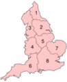
Redcliffe-Maud proposed provinces; East Anglia is marked 7


See also
 In Spanish: Anglia Oriental para niños
