Cambridgeshire facts for kids
Quick facts for kids
Cambridgeshire
|
|||||||||||||||||||||||||||||||||||||||||||||||||||||||||||
|---|---|---|---|---|---|---|---|---|---|---|---|---|---|---|---|---|---|---|---|---|---|---|---|---|---|---|---|---|---|---|---|---|---|---|---|---|---|---|---|---|---|---|---|---|---|---|---|---|---|---|---|---|---|---|---|---|---|---|---|
|
|||||||||||||||||||||||||||||||||||||||||||||||||||||||||||
| Sovereign state | United Kingdom | ||||||||||||||||||||||||||||||||||||||||||||||||||||||||||
| Constituent country | England | ||||||||||||||||||||||||||||||||||||||||||||||||||||||||||
| Region | East of England | ||||||||||||||||||||||||||||||||||||||||||||||||||||||||||
| Established | 1 April 1974 | ||||||||||||||||||||||||||||||||||||||||||||||||||||||||||
| Established by | Local Government Act 1972 | ||||||||||||||||||||||||||||||||||||||||||||||||||||||||||
| Preceded by | Cambridgeshire and Isle of Ely Huntingdon and Peterborough |
||||||||||||||||||||||||||||||||||||||||||||||||||||||||||
| Origin | Ancient | ||||||||||||||||||||||||||||||||||||||||||||||||||||||||||
| Time zone | UTC±00:00 (Greenwich Mean Time) | ||||||||||||||||||||||||||||||||||||||||||||||||||||||||||
| • Summer (DST) | UTC+01:00 (British Summer Time) | ||||||||||||||||||||||||||||||||||||||||||||||||||||||||||
| Members of Parliament | List of MPs | ||||||||||||||||||||||||||||||||||||||||||||||||||||||||||
| Police | Cambridgeshire Constabulary | ||||||||||||||||||||||||||||||||||||||||||||||||||||||||||
|
|||||||||||||||||||||||||||||||||||||||||||||||||||||||||||
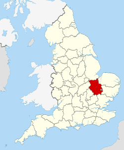
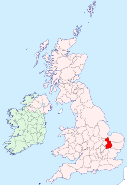
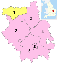
Cambridgeshire (often called Cambs.) is a county in the East of England. It shares borders with several other counties like Lincolnshire to the north and Suffolk to the east. The biggest city in Cambridgeshire is Peterborough. The county town, which is like its main administrative center, is Cambridge.
Cambridgeshire covers about 3,389 square kilometers (1,308 square miles). It has a population of over 850,000 people. While Peterborough and Cambridge are the largest cities, much of the county is countryside. You'll also find the city of Ely and towns like Wisbech and St Neots.
A big part of northern and eastern Cambridgeshire is covered by the Fens. These are very flat, low-lying areas that used to be marshes. They are now kept dry by special ditches and canals. Holme Fen in Cambridgeshire is the lowest point in the UK, sitting 2.75 meters (9 feet) below sea level! Because the land is so flat, any small hills, like the one Ely is built on, really stand out. The southern and western parts of the county have gently rolling hills. Important rivers in Cambridgeshire include the River Nene, the River Great Ouse, and the River Cam, which flows through Cambridge.
Contents
History of Cambridgeshire
Cambridgeshire has a very long history. It's home to Flag Fen, one of the oldest known permanent settlements from the Neolithic (New Stone Age) period in the UK. Another amazing discovery is the Must Farm quarry near Whittlesey. It's been called "Britain's Pompeii" because it has incredibly well-preserved Bronze Age homes. Many ancient items from the Stone, Bronze, and Iron Ages have been found in places like Isleham.
The area was settled by the Anglo-Saxons starting in the 400s. Scientists have even studied ancient skeletons found here. They found that some people were migrants from other parts of Europe, some were native Britons, and some had mixed ancestry. This shows that people from different backgrounds lived and married here long ago.
Cambridgeshire was first mentioned in the Domesday Book (a famous survey from 1086) as "Grantbridgeshire." Over time, the county's borders have changed a lot. In 1965, two areas, Cambridgeshire and the Isle of Ely, joined together. Then, in 1974, this new area merged with Huntingdon and Peterborough to form the Cambridgeshire we know today.
Since 1998, the City of Peterborough has been managed separately. However, it's still connected to Cambridgeshire for things like policing and fire services.
In 2002, the Pasqueflower was chosen as Cambridgeshire's unofficial county flower. The Cambridgeshire Regiment, a local army unit, fought in several wars, including the Boer War and both World Wars.
During the Second World War, many airfields were built in Cambridgeshire. This was because the county is flat and close to Europe. These airfields were used by the British Royal Air Force (RAF) and the American Air Force (USAAF). The Cambridge American Cemetery and Memorial in Madingley is the only place in England where American soldiers who died in WWII are buried.
People from Cambridgeshire have some interesting nicknames, like "Cambridgeshire Camel" or "Cambridgeshire Crane." The term "Fen Tigers" is also used for people who live and work in the Fens.
You can find old documents about Cambridgeshire at the Cambridgeshire Archives. Local libraries also have special collections about the county's history.
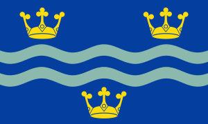
Cambridgeshire's Flag
Cambridgeshire got its official county flag on February 1, 2015. The design was chosen from a competition. It has three golden crowns, with two wavy lines in the middle. The crowns represent East Anglia, and the wavy lines stand for the River Cam. These lines are also in the colors of Cambridge University.
Geography of Cambridgeshire
As mentioned, much of Cambridgeshire is very flat. Holme Fen is the lowest point in the UK, at 2.75 meters (9 feet) below sea level. The highest point in the modern county is in Great Chishill, which is 146 meters (480 feet) above sea level. However, this area used to be part of Essex. The highest point in the historic county is near Castle Camps, at 128 meters (420 feet) above sea level.
Other notable hills include Little Trees Hill and Wandlebury Hill in the Gog Magog Hills.
Wicken Fen is a large nature reserve managed by the National Trust. It's a special place for wildlife.
Green Belt Area
Around the city of Cambridge, there's a special area called the "green belt." This area, which includes places like Waterbeach and Duxford, is protected. It helps stop the city from growing too much and keeps the countryside open.
Economy of Cambridgeshire
Cambridgeshire has a strong economy. Many parts of the county are used for farming. Near Cambridge, there's an area known as Silicon Fen. This is where many high-tech companies are located, focusing on things like electronics, computers, and biotechnology. For example, ARM Limited, a big technology company, is based in Cherry Hinton.
The Port of Wisbech on the River Nene is the county's only remaining port, where goods can be shipped. The RAF also has several bases in the Huntingdon and St Ives areas.
Education in Cambridgeshire
Cambridgeshire has many schools. There are over 240 state schools, plus independent schools like King's Ely and Wisbech Grammar School. These two schools are very old, founded in 970 and 1379!
Some secondary schools in Cambridgeshire are called "Village Colleges." These are special institutions unique to the county, like Comberton Village College.
Universities and Colleges
Cambridgeshire is home to several important places for higher education:
- The University of Cambridge: This is the second-oldest university in the English-speaking world and is known as one of the best universities globally.
- Anglia Ruskin University: It has campuses in Cambridge and Peterborough.
- The Open University: This university has a regional center in Cambridge.
- The University Centre Peterborough: This is a partnership between Anglia Ruskin University and Peterborough Regional College.
- The College of West Anglia: It has campuses near Cambridge and in Wisbech.
Towns and Villages
Here are some of the main towns and cities in Cambridgeshire:
- Burwell
- Cambridge
- Chatteris
- Cottenham
- Ely
- Godmanchester
- Huntingdon
- Littleport
- March
- Peterborough
- Ramsey
- Sawston
- Sawtry
- Soham
- St Ives
- St Neots
- Wisbech
- Whittlesey
- Yaxley
The town of Newmarket is almost completely surrounded by Cambridgeshire, but it's actually part of Suffolk!
Climate in Cambridgeshire
Cambridgeshire has a mild climate, similar to the rest of the UK. However, it's a bit drier because it's low-lying and further east. This means that winds coming from the west have already dropped most of their rain before reaching Cambridgeshire. Winters are usually a little cooler than the average for England. Snowfall can be a bit more common here because of the colder winters and easterly winds. Summers are average or slightly warmer, with less cloud cover.
Culture and Sports
Sports in Cambridgeshire
Football has been popular in Cambridgeshire for a long time. In the 1800s, students at the University of Cambridge created their own rules for football, known as the Cambridge rules. These rules greatly influenced the official laws of the Football Association.
Cambridgeshire is also where the sport of bandy began. Bandy is a bit like ice hockey but played with a ball. The first official rules for bandy were written here in 1882 by Charles Goodman Tebbutt.
Fen skating is a traditional sport in the Fens. People would skate on the frozen waterways. In 1879, the National Ice Skating Association was set up in Cambridge.
In 2015, the first Tour of Cambridgeshire cycle race took place. Over 6,000 riders took part in the 128-kilometer (80-mile) race.
The River Cam is used for rowing races by the university, like the Lent Bumps and May Bumps. The River Great Ouse was even used for The Boat Race in 2021. Cambridgeshire has one horse racing track, Huntingdon Racecourse.
Arts and Literature
Cambridge is home to the Kettle's Yard art gallery. Wysing Arts Centre is another art space near Bourn. Every July, over 370 artists open their studios to visitors during Cambridge Open Studios.
The Fenland Poet Laureate awards celebrate poets in the northern part of the county.
Cambridgeshire also has a history of theatre. The Angles Theatre in Wisbech is an old Georgian theatre that is still used today. In Cambridge, the ADC Theatre is famous for the Footlights, a student comedy group.
Media
Television and Radio
Cambridgeshire gets its TV news from BBC East and ITV Anglia, which broadcast from Norwich.
For radio, you can listen to BBC Radio Cambridgeshire. There are also commercial radio stations like Heart East, Greatest Hits Radio East, and Star Radio.
Places to Visit
- Angles Theatre
- Anglesey Abbey


- Brampton Wood
- Buckden Towers

- Cambridge American Cemetery and Memorial
- Cambridge University Museum of Zoology
- Castor Hanglands NNR
- Cherry Hinton Chalk Pits
- Denny Abbey

- Devil's Dyke
- Down Field Windmill
- Duxford Chapel

- Duxford Airfield
- Elton Hall

- Ely Cathedral

- Fitzwilliam Museum, Cambridge
- Flag Fen
- Fowlmere RSPB reserve
- Gamsey Wood Nature Reserve
- Grafham Water Nature Reserve
- Great Gransden Post Mill
- Hereward Way
- Hinchingbrooke House

- Houghton Mill

- Icknield Way
- Imperial War Museum Duxford

- Kettle's Yard
- Kimbolton Castle

- King's College, Cambridge
- Lattersey Nature Reserve
- Lode Watermill

- Longthorpe Tower
- Magog Down
- March & District Museum
- Milton Country Park

- Nene Park

- Nene Valley Railway

- Nene Way
- New Bedford River
- Octavia Hill Birthplace House

- Old Bedford River
- Oliver Cromwell's House
- Ouse Valley Way
- Ouse Washes
- Parker's Piece, Cambridge, birthplace of modern football
- Paxton Pits Nature Reserve
- Peckover House & Garden

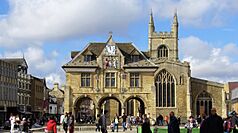
- Peterborough Cathedral

- Port of Wisbech
- Prickwillow Drainage Engine Museum

- Ramsey Abbey

- River Cam
- River Great Ouse
- River Nene
- Round Church, Cambridge
- RSPB Nene Washes
- RSPB Ouse Washes
- Stretham Old Engine

- Three Shires Bridleway
- University of Cambridge Museum of Archaeology and Anthropology
- Wandlebury Country Park

- Wicken Fen

- Wimpole Hall

- Wisbech Castle

- Wisbech & Fenland Museum
- Wisbech and March Bramley Line

- WWT Welney
- Wysing Arts Centre
Famous People from Cambridgeshire
- Oliver Cromwell (1599–1658): A very important figure in English history. He was a leader during the English Civil War and later became the Lord Protector of England, Scotland, and Ireland.
See also
 In Spanish: Cambridgeshire para niños
 | Aaron Henry |
 | T. R. M. Howard |
 | Jesse Jackson |


