
Icknield Way facts for kids

The Icknield Way is a very old path in southern and eastern England. It stretches from Norfolk in the east to Wiltshire in the west. This ancient route follows the edge of a chalky hillside, which includes the Berkshire Downs and Chiltern Hills.
Contents
What is the Icknield Way?
Many people believe the Icknield Way is one of the oldest roads in Great Britain. It is thought to have existed long before the Romans arrived. However, some experts question if it was truly a major route in prehistoric times.
The name "Icknield Way" comes from an old British language. It might be named after the Iceni tribe, who lived in East Anglia. They may have used this path to trade with other parts of the country. Some also think the road is even older, going back to prehistoric times. The name was first used for the part of the path south of the River Thames. Today, it usually refers to the path north of the Thames.
From ancient times, like the Iron Age (before the Romans came in 43 AD) and through Anglo-Saxon times, the path went from Berkshire through Oxfordshire. It crossed the River Thames at Cholsey, near Wallingford.
How do we know about the Icknield Way?
The Icknield Way is first mentioned in old Anglo-Saxon documents called charters. These documents date back to the year 903. The oldest copies we have were made in the 12th and 13th centuries. They use different spellings like Ic(c)enhilde weġ and Icenhilde weġ.
These old charters mention places along the path. They talk about locations like Wanborough, Hardwell in Uffington, Lockinge, Harwell, Blewbury and Risborough. These places cover about 40 miles (64 km) from Wiltshire to Buckinghamshire.
The "Four Highways" of Medieval England
The Icknield Way was one of four important roads in medieval England. Around the 1130s, writers like Henry of Huntingdon wrote about these roads. He said the Ermine Street, Fosse Way, Watling Street and Icknield Way were built by kings.
A law called the Leges Edwardi Confessoris gave special protection to travelers on these roads. It said the Icknield Way stretched across the whole kingdom. Later, Geoffrey of Monmouth added to the story. He said a king named Belinus improved these four roads. This made them clearly protected highways.
Around 1250, a map of Britain called Scema Britannie showed these Four Highways. The map, drawn by Matthew Paris, showed the Icknield Way as a straight line. It went from Salisbury (which was Old Sarum back then) to Bury St Edmunds. This line crossed the other three roads near Dunstable.
Icknield Street: A Different Path
In the 1300s, a writer named Ranulf Higdon described a different route for the Icknield Way. He said it went from Winchester to Tynemouth. This route passed through places like Birmingham, Lichfield, Derby, Chesterfield and York.
This different route includes a Roman road that runs from Bourton-on-the-Water to Templeborough. Today, this Roman road is called Icknield Street (or Ryknild Street). This helps people tell it apart from the older Icknield Way.
Where does the Icknield Way go?

In many places, the Icknield Way was not just one single path. It was often several routes running side-by-side. This was especially true where it followed the edge of the Chilterns. People probably used different routes depending on the season. For example, some paths might have been better in summer and others in winter. This also helped manage the amount of traffic, especially for herds of animals.
To the west, you can find traces of the path below the hills of the Berkshire Downs. Near Wantage, the path along the top of the Downs is called The Ridgeway. The name Icknield Way is used for a path lower down, near the villages that grew around natural springs.
Between Lewknor and Ivinghoe, there are two parallel paths. They are known as the Lower Icknield Way and the Upper Icknield Way. In Cambridgeshire, other paths like Street Way and Ditch Way are thought to be different routes. They might have been used in different seasons too.
Many modern roads follow parts of the Icknield Way. For example, the B489 road from Aston Clinton to Dunstable. Also, the A505 from Baldock to Royston. In some areas, especially from east of Luton to Ickleford (which got its name from the Way crossing a stream), the route is followed by smaller roads. In many places, you can't see the old path clearly. However, you can spot clues like ancient burial mounds (called barrows) that line the route. The path itself might be a bit sunken from being used so much over time. It's like a line of historical sites spread out along the landscape.
The Icknield Way used to mark the border between Hertfordshire and Cambridgeshire. At one point, Royston was even split in half by this boundary. Royston is also where the Icknield Way crosses another old road, Ermine Street.
Some writers believe the Icknield Way went as far west as Exeter. Others say it only went to Salisbury. To the northeast, places like Icklingham, Suffolk, and Caistor-by-Norwich, Yarmouth and Hunstanton, Norfolk have been suggested as its end points. In the 13th century, a road near Hunstanton was called Ykenildestrethe and Ikelynge Street. This supports the idea of a western route.
Modern Walking Paths
Today, new long-distance footpaths have been created. These paths generally follow the old Icknield Way route. They stretch from Lyme Regis on the Dorset coast to Holme-next-the-Sea on the Norfolk coast.
In 1947, a report suggested creating a path from Seaton Bay to the Chiltern hills. In 1956, Tom Stephenson proposed an even longer route to Cambridge. A route through Norfolk was discussed in the 1960s.
The first part of the path to become an official Long-Distance Footpath was from Overton Hill to Ivinghoe Beacon. It was opened in 1973 and named the Ridgeway. The Peddars Way, which goes from Knettishall Heath to Holme-next-the-Sea, is part of a larger National Trail. It opened in 1986.
Between the Ridgeway and Peddars Way, some parts of the original Icknield Way are now covered by roads or buildings. So, a new route was planned to avoid walking on roads. In 1992, this new route was named the Icknield Way Path. The Wessex Ridgeway, from Lyme Regis to Marlborough, opened in 1994.
Charles Thurstan Shaw, an archaeologist and walker, started the Icknield Way Association in 1984. This group worked to reopen the entire Icknield Way as a long-distance path. He also wrote the first guide for walkers that year.
The author Ray Quinlan has combined several of these paths. He calls his combined route the Greater Ridgeway. It includes most of the Wessex Ridgeway, the Ridgeway National Trail, the Icknield Way Path, the Peddars Way, and a small part of the Norfolk Coast Path. This combined path is about 584 km (363 miles) long. It goes from Lyme Regis to Hunstanton.
Some parts of the Ridgeway National Trail and the Icknield Way Path are only for walking. So, special routes have been made for horse riders and cyclists. These are called the Icknield Way Path Riders Route or Icknield Way Trail. This route runs from Bledlow to Roudham Heath. There, it connects with the Peddars Way Riders Route.
Artists and Writers Inspired by the Way
The Icknield Way has been a source of inspiration for many artists and writers. Spencer Gore, a famous artist, painted the route in 1912. His work helped start British Modernism in art.
One of the most famous writers to travel the Icknield Way was the poet Edward Thomas. He walked the path in 1911 and wrote a book about it in 1913. Thomas was very interested in old roads. His book, though written like a 10-day journey, was actually written over a year. He often walked with his brother Julian, sometimes covering 30-40 miles (48-64 km) a day.
More recently, the nature writer Robert MacFarlane started his book about walking ancient paths, The Old Ways, by walking the Icknield Way. He hoped to feel a connection to Edward Thomas by walking the same path.
The author George R. R. Martin used the idea of the "Four Highways" as a model. He used it for the Kingsway in his A Song of Ice and Fire novels. Also, the first episode of the 2016-2017 TV show Britain's Ancient Tracks with Tony Robinson was about the Icknield Way. It showed amazing drone views of the path.
Images for kids
-
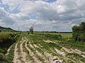
Icknield Way near Lewknor in Oxfordshire
-
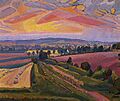
Spencer Gore: "Icknield Way", 1912. Used as the cover picture of "The Icknield Way Path - A Walkers' Guide" published by the Icknield Way Association in 2012
