
Exeter facts for kids
Quick facts for kids
Exeter
|
|||
|---|---|---|---|
|
City and non-metropolitan district
|
|||
|
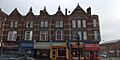
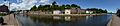
Clockwise from top: Exeter Cathedral; Southernhay; Sidwell Street in the city centre; Exeter Quay; Royal Albert Memorial Museum; The Iron Bridge
|
|||
|
|||
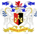
| Motto(s):
Semper fidelis (Always faithful)
|
|||

|
|||

Exeter
Location in the United Kingdom

Exeter
Location in England

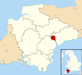
Exeter
Location in Devon
|
|||
| Sovereign state | United Kingdom | ||
| Country | England | ||
| Region | South West England | ||
| Ceremonial and shire county | Devon | ||
| City status | Time immemorial | ||
| Non-metropolitan district | 1974 | ||
| Government | |||
| • Type | City council | ||
| • Body | Exeter City Council | ||
| Area | |||
| • Total | 18.16 sq mi (47.04 km2) | ||
| Area rank | 274th (of 326) | ||
| Population
(2005 est.)
|
|||
| • Total | 131,405 | ||
| • Rank | 171st (of 326) | ||
| • Density | 7,235.1/sq mi (2,793.47/km2) | ||
| • Demonyms | Exonian | ||
| • Ethnicity (2011) |
93.05% White
|
||
| Time zone | UTC0 (GMT) | ||
| • Summer (DST) | UTC+1 (BST) | ||
| Postcode district |
EX1-6
|
||
| Area code(s) | 01392 | ||
,_Cathedral_Church_of_Saint_Peter_--_2013_--_1401.jpg)


Exeter is a historic city in South West England. It is the main town of Devon county. The city sits on the River Exe, about 36 miles (58 km) northeast of Plymouth.
Exeter was an important Roman base long ago. In the Middle Ages, it became a religious center. Exeter Cathedral, built in the 11th century, became an Anglican church later. The city grew rich from the wool trade. After the Second World War, much of Exeter was rebuilt. Today, it is a hub for education, business, and tourism. The University of Exeter has two campuses here.
Exeter is managed by the Devon County Council. It is the county town of Devon.
Contents
What's in a Name?
The name Exeter comes from the Old English word Escanceaster. This word combines the name of the River Exe with -ceaster. -Ceaster means "fortress" or "military camp" in Old English. It comes from the Latin word castrum.
The name "Exe" itself means "water" or "full of fish". You can find similar river names like Axe and Esk in England.
A Look Back at Exeter's History
Early Settlements and Roman Times
Exeter started as small settlements on a dry ridge. This spot was perfect because it overlooked a river full of fish. The land around it was also very fertile.
Coins found here suggest people traded with the Mediterranean as early as 250 BC. This means it was an important place even before the Romans arrived.

Around AD 55, the Romans built a fort called Isca. It was a large, rectangular fort. This fort was the base for the 5,000-man Second Augustan Legion. This legion was once led by Vespasian, who later became a Roman Emperor.
The fort was abandoned around AD 75. Its land was then used for civilian buildings. A large public bathhouse was replaced by a forum (a public square) and a basilica (a large public building). The Roman wall around the fort was later used for Exeter's city walls. About 70% of the Roman wall still exists today.
Exeter was most successful in the early 4th century. Many Roman coins have been found, showing trade and industry. However, after 380 AD, fewer coins are found, suggesting a quick decline.
Medieval Exeter
After the Romans left around 410 AD, not much is known about Exeter until the 7th century. By then, the Saxons controlled the city. They had defeated the British people in 658.
In 876, Danish Vikings attacked and briefly captured Exeter. Alfred the Great drove them out. He then made Exeter one of the four main fortified towns, called burhs, in Devon. He rebuilt the city walls using the old Roman lines. These strong walls helped the city defend against another Viking attack in 893.
King Athelstan made the walls even stronger around 928. He also made the remaining Britons leave the city. They were sent beyond the River Tamar, which became the border of Devon.
In 1001, the Danes failed to enter the city again. But in 1003, they managed to plunder it. This happened because the French reeve (a local official) of Emma of Normandy let them in. Emma had been given the city as part of her marriage to Æthelred the Unready.

After the Norman Conquest in 1066, Exeter rebelled against King William. William besieged the city for 18 days. He then accepted its surrender, promising not to harm the city. However, he quickly built Rougemont Castle to control the area.
In 1136, during a civil war called the Anarchy, Rougemont Castle was held against King Stephen. Stephen besieged it for three months.

.jpg)
Exeter had a weekly market from at least 1213. By 1281, it was the only town in the southwest with three market days a week. The city also had seven annual fairs.
Before 1290, Exeter was home to England's most westerly Jewish community. They were expelled from England in that year.
In medieval times, both the church leaders and citizens had access to advanced water systems. These brought clean drinking water from springs into the city. Part of these systems included tunnels, which you can still visit today.
Exeter and Bristol were the first cities in medieval England to have a Common Council. This council was formed by twelve "better and more discreet men." They were re-elected each year.
Modern Exeter
Tudor and Stuart Eras

In 1537, Exeter became a "county corporate." This meant it had its own local government, separate from the county. In 1549, the city survived a month-long siege by the Prayer Book rebels. These were people from Devon and Cornwall who were angry about King Edward VI's new religious rules. The rebels burned city gates but were eventually defeated.
In 1561, John Hooker helped create the Court of Orphans. This was a local government system for families whose main income earner had died. The court managed money left to orphan children until they turned 21. The money from an orphan tax helped build the Exeter canal.
Exeter's motto, Semper fidelis (Always faithful), is said to have been given by Queen Elizabeth I. This was to thank the city for sending ships to fight the Spanish Armada in 1588. However, its first recorded use was in 1660. Schools in Exeter often teach that Charles II gave the motto in 1660. This was because of Exeter's role in the English Civil War.
During the English Civil War, Exeter was first controlled by Parliament. But in 1643, it was captured by the Royalist Army. The city remained under the king's control until near the end of the war. Exeter was a rich city then, with a strong wool trade. Goods were sold to places like the West Indies, Spain, France, and Italy.
Georgian and Victorian Eras

In the early Industrial Revolution, Exeter's industries used local farm products. The city's fast-flowing river provided water power. However, when steam power became popular, Exeter was too far from coal and iron. This meant the city grew less quickly than other industrial cities.
In 1778, a new stone bridge was opened across the Exe. It cost £30,000 and had three arches.

In 1832, cholera reached Exeter. Dr Thomas Shapter documented this event.
The first railway arrived in Exeter in 1844. It opened a station at St Davids. Later, more stations opened, connecting Exeter to London and other cities.
In the late 1880s, the Exeter Electric Light Company started providing electricity. In 1896, a new sewerage system was built for £88,000. This helped reduce infectious diseases.

Horse-drawn trams were introduced in 1882. They had three lines from the city's East Gate.
20th Century Changes

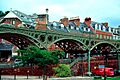
A new bridge across the Exe opened in 1905. It was made of cast iron and steel. In the same year, electric trams replaced the horse trams. However, trams caused traffic jams in Exeter's narrow streets. The council decided to replace them with buses. The last tram ran on August 19, 1931.

Exeter was heavily bombed by the German Luftwaffe during the Second World War. Between 1940 and 1942, 18 raids flattened much of the city center. In April and May 1942, as part of the Baedeker Blitz, 40 acres (16 hectares) of the city were destroyed by fire bombs. Many historic buildings were lost.
The No. 307 Polish Night Fighter Squadron defended Exeter from 1941 to 1943. They were called the 'Lwów Eagle Owls'. The city of Lwów shared Exeter's motto, 'Semper Fidelis'. On May 4, 1942, the Polish squadron stopped German bombers from releasing their bombs on Exeter. 156 people died, but the squadron had no losses.
To remember this friendship, the squadron gave Exeter a Polish flag in 1942. Since 2012, a Polish flag is raised over the Guildhall on November 15, known as '307 Squadron Day'.
After the war, large parts of the city center were rebuilt in the 1950s. Not much effort was made to save old buildings. The street plan was changed to improve traffic. Modern buildings now stand next to the old red sandstone ones. One special building, "The House That Moved", was saved from demolition in 1961. It was moved to a new spot.

On October 27, 1960, heavy rain caused the River Exe to flood large areas of Exeter. Water rose up to 2 meters high in some places. 2,500 properties were flooded. These floods led to new flood defences being built. Work started in 1965 and cost £8 million. The defenses included three flood relief channels.
Exeter in the 21st Century
The Princesshay shopping center was redeveloped between 2005 and 2007. It now includes 123 homes.
In May 2008, there was an attempted terrorist attack at a cafe in Princesshay. Only the bomber was injured.

On October 12, 2012, John Lewis opened its first high-street home store on Sidwell Street. It was the biggest John Lewis store to open that year.
A £30 million plan to improve flood defenses was approved in March 2015. The Exeter Pound, a local currency, was used from 2015 to 2018.
A serious fire broke out in central Exeter on October 28, 2016. The Royal Clarence Hotel and other buildings were badly damaged. Restoration plans were announced, but the hotel will now be converted into luxury apartments.
On February 27, 2021, a 2,200 lb (1,000 kg) Second World War bomb was found at a construction site. Over 2,600 people were evacuated. Bomb disposal experts safely detonated it. The explosion caused damage to many nearby homes.
How Exeter is Governed


Exeter is part of two areas for national elections. Most of the city is in the Exeter constituency. Two areas, St Loyes and Topsham, are in East Devon. The current MP for Exeter is Steve Race.
Public Services in Exeter
- Police: The Devon and Cornwall Constabulary provides policing. Their main office is in Exeter.
- Fire Service: The Devon and Somerset Fire and Rescue Service is headquartered near Exeter. It has two fire stations in the city.
- Hospitals: The Royal Devon University Healthcare NHS Foundation Trust has a large hospital southeast of the city center.
- Ambulance: South Western Ambulance Service provides ambulance services. Their main control center for the west is in Exeter.
Exeter's Location and Climate
Geography of Exeter

Exeter is built on the east bank of the River Exe. It sits on a ridge of land with a steep hill behind it. This area is where the Exe meets a wide flood plain and estuary, which can sometimes flood. Historically, this was the lowest point where the river could be crossed. This, along with the easily defended high ground, made it a natural place for people to settle and trade.
Exeter is mostly on sandstone and conglomerate rock. The city's ridge includes a volcanic plug, where Rougemont Castle is located. The cathedral is also on this ridge, so it can be seen from far away.
Exeter is about 80 miles (129 km) west-southwest of Salisbury. It is 158 miles (254 km) west-southwest of London.
Exeter's Weather

Exeter has mild, wet winters. Colder periods are usually short. Summers are warm and changeable, with both hot and rainy spells. Temperatures don't change much throughout the year. However, the city's hills and valleys can make nights colder and days warmer in some spots.
The hottest month is July, with an average high of 21.8°C (71.2°F). The coldest month is January, with an average high of 9.1°C (48.4°F). October is the wettest month. The highest temperature ever recorded in Exeter was 33.5°C (92.3°F) in June 1976. The lowest was -16.4°C (2.5°F) in December 2010.
People of Exeter
In 2011, Exeter's population was 117,773. This was 6,697 more people than in 2001. Most of Exeter's population is White (93.1%). The largest minority group is Chinese (1.7%).
The number of people from China and other Asian countries increased a lot between 2001 and 2011. This shows how diverse the city is becoming.
Many people commute into Exeter every day from nearby towns. Exeter provides jobs, services, and shopping for these areas.
Exeter's Economy


The Met Office, which is the UK's main weather forecasting organization, moved to Exeter in 2004. It is one of the biggest employers in the area. Other large employers include the University of Exeter, Devon County Council, and the Royal Devon and Exeter NHS Foundation Trust.
Exeter is considered one of the most profitable places for businesses. Many workers in Exeter have professional jobs (39%), which is higher than the national average.
The city center has many shops. The High Street mainly has large national store chains. However, other areas like Princesshay and the Guildhall Shopping Centre offer more varied shops. Smaller streets like Gandy Street also have independent shops.
Exeter was given Fairtrade City status on June 26, 2004.
Tourism is important, but it does not dominate Exeter's economy. Only about 7% of jobs depend on tourism.
Famous Places in Exeter

Exeter has many notable buildings and landmarks:
Religious Buildings
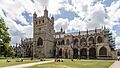
- Exeter Cathedral: This impressive cathedral was founded in 1050. It has the longest uninterrupted vaulted ceiling in England. A statue of Richard Hooker, a famous 16th-century theologian born in Exeter, stands in the Cathedral Close.
- St Nicholas Priory: Located in Mint Lane, these are the remains of an old monastery. It was home to Benedictine monks for over 400 years. Today, it's a museum owned by the city council.
- Medieval Churches: There are several old churches, including St Mary Steps with its unique clock.
- Exeter Synagogue: This is the third oldest synagogue in Britain, completed in 1763.
- St Thomas' Church: Built in the 13th century, it was rebuilt in the 17th century after a fire.

Other Important Buildings and Features

- Rougemont Castle: The ruins of this castle are still visible. Parts of it were used as courts until 2004.
- Guildhall: This building has medieval foundations. It is said to be the oldest municipal building in England still in use.
- Mol's Coffee House: A historic building near the Cathedral Close.
- Tuckers' Hall: A 15th-century guild hall still used today.
- Custom House: Located in the Quay area, it is the oldest brick building in the city.
- "The House That Moved": This 14th-century Tudor building got its name in 1961. It was moved from its original spot to make way for a new road. It weighed over 21 tonnes!
- Parliament Street: One of the narrowest streets in the world, located in the city center.
- Butts Ferry: An old cable ferry that crosses the River Exe.
- Devon County War Memorial: Located in the Cathedral Close, it was designed by Sir Edwin Lutyens.
Northernhay Gardens
Northernhay Gardens are just outside the castle. They are the oldest public open space in England. They were first created in 1612 for people to enjoy walks.
Getting Around Exeter
By Car

The M5 motorway connects Exeter to Bristol and Birmingham. The A30 road offers a more direct route to London. The M5 is the modern lowest point where the River Exe can be crossed.
Traffic in Exeter can be busy, especially around the Exe Bridges. To help with traffic, Devon County Council opened three park and ride sites.
By Bus
Exeter's main local bus company is Stagecoach South West. Dartline Coaches also operates some services. A new bus station opened on July 25, 2021.
By Train

Exeter is a major train hub in the South West. It connects to most train lines in Devon. This means you can reach many Devon stations directly from Exeter St Davids.
Exeter has three main train stations:
- Exeter St Davids: Serves all services and is a major interchange.
- Exeter Central: Closer to the city center, serves local and London Waterloo routes.
- Exeter St Thomas: Serves the western side of the city.
There are also seven smaller stations for local services.
Two main train routes connect Exeter to London. One is faster to London Paddington, and the other is slower to London Waterloo. Another main line connects Exeter to Bristol, Birmingham, and other northern cities.
In 2014, a section of the railway line at Dawlish was damaged by storms. This led to discussions about reopening an older line from Okehampton to Plymouth as an alternative route.
By Air

Exeter Airport is east of the city. Flybe was a major local airline based here until 2020. TUI Airways also operates flights from Exeter to places like Faro and Mallorca. The airport offers flights to British and Irish airports, as well as charter flights.
By Canal

The Exeter Canal, also called the Exeter Ship Canal, was built around 1566. It is one of Britain's oldest artificial waterways. It was built to bypass a weir (a small dam) that blocked trade on the River Exe.
The canal was originally 3 feet (0.9 m) deep and 16 feet (4.9 m) wide. It ran for 2 miles (3.2 km). It was later made longer and deeper. The canal was successful until the mid-19th century. Today, it is mostly used for fun activities. The city basin is part of a £24 million redevelopment project.
Learning in Exeter

The University of Exeter has two campuses in the city. It includes a Business School and the Bill Douglas Cinema Museum.
Exeter College is a college for further education. In 2014, the Exeter Mathematics School was opened. This is a free school for students specializing in Mathematics.
Exeter's school system has changed over time. Now, it follows the usual UK pattern with primary and secondary schools. There are 25 primary schools and five secondary schools in Exeter.
Exeter also has several independent schools. These include Exeter School and The Maynard School. There are also special schools for students with sensory needs.
Places of Worship

Exeter has many churches and other religious buildings. Most are Christian. The Church of England cathedral is a major landmark. In medieval times, Exeter had nearly 70 churches, chapels, and monasteries.
Exeter Cathedral is the main church for the Bishop of Exeter. The current building was finished around 1400.
There are two Catholic Churches: the Sacred Heart and the Blessed Sacrament.
Exeter Synagogue, built in 1763, is near Mary Arches Street.
Exeter's mosque and Islamic center are on York Road. The first mosque opened in 1977. A new, purpose-built mosque opened in 2011.
In the 2001 census, 69.12% of Exeter's population said they were Christian. This was slightly lower than the regional average. However, 20.45% of people in Exeter said they had no religion, which was higher than the regional average.
Anglican Churches in Exeter

Many Anglican churches are in Exeter.
- St David's: Built between 1897 and 1900, it has a tower on the northeast side.
- St Edmund-on-the-Bridge: Originally built on the Exe Bridge around 1230–40.
- St Martin's: Located in the Cathedral Close.
- St Mary Steps: Has a Norman font and a remarkable old clock.
- St Mary Arches: A Norman church that was restored after bombing in 1942.
- St Pancras: From the 13th century, with a Norman font.
- St Petroc's: Has an unusual layout with two chancels.
- St Michael and All Angels Church: On Mount Dinham, its spire is taller than the cathedral towers.
Sports in Exeter
Rugby Union
Exeter's professional rugby union team is the Exeter Chiefs. They were founded in 1871. Since 2006, they have played their home games at Sandy Park stadium. They have been in the top English rugby division since 2010. The Chiefs have won the English championship twice (2017, 2020). In 2020, they also became European Champions.
Exeter also has two other rugby clubs: Wessex Rugby Club and Exeter Saracens Rugby Club.
Football
Exeter City is Exeter's only professional football club. They play their home games at St James Park. The club was a founding member of the Football League's Third Division in 1920. They have never reached higher than the third tier of English football.
Other Sports
Exeter Cricket Club has three teams that play in the Devon Cricket League. They play their home games at County Ground.
Exeter Rowing Club competes locally and nationally. The City of Exeter Rowing Regatta is held every July. It is the oldest and largest regatta in the South West.
Exeter's speedway team, Exeter Falcons, started in 1929. They were based at the County Ground until 2005. The team was revived in 2015 and is currently based in Plymouth.
Culture and Arts

Literature

The Exeter Book, a collection of Anglo-Saxon poetry, is kept in Exeter Cathedral. It is one of only four manuscripts that contain all surviving Old English poetry. The book includes shorter poems and a series of riddles. Some of these riddles are carved on a polished steel monument in High Street.
Another famous manuscript is the Liber Exoniensis or Exon Domesday. This is a land and tax record from 1086. It is also kept in Exeter Cathedral.
In 2019, Exeter became a UNESCO City of Literature.
Theatre
Exeter has several theatres:
- Northcott Theatre: Located at the University of Exeter. It is one of the few English theatres with its own acting company.
- Barnfield Theatre: Originally built as Barnfield Hall in the late 19th century. It became a theatre in 1972.
- Cygnet Theatre: Home of the Cygnet Training Theatre.
- Exeter Corn Exchange: Hosts modern performances, theatre, and dance.
Music
The largest orchestra in Exeter is the EMG Symphony Orchestra.
Chris Martin, the lead singer of Coldplay, was born in Exeter. He grew up nearby and went to Exeter Cathedral School. Coldplay has often returned to Exeter to perform.
Muse, another major rock band, has ties to Exeter. The band members grew up in nearby Teignmouth. Some of their first performances were at Exeter's Cavern Club in the early 1990s.
The Cavern Club has been a popular live music venue since 1991. It has hosted famous artists like Coldplay, Muse, and Biffy Clyro. It is also a popular student nightclub.
Thom Yorke, lead singer of Radiohead, attended the University of Exeter. He helped set up the Cavern Club.
The University's Great Hall is also a popular venue for concerts. Westpoint Arena, on the city's outskirts, has hosted major artists too.
Museums and Galleries
- Royal Albert Memorial Museum: Exeter's main museum. It has important collections from the region and around the world. It reopened in 2011 after a big renovation and won the UK Museum of the Year award in 2012.
- University of Exeter: Has a large fine art collection and exhibition spaces.
- Exeter Phoenix: A leading contemporary arts venue in South West England.
Newspapers
- Express and Echo: Published weekly on Thursdays.
- The Western Morning News: A daily regional paper printed in Plymouth.
- Exeposé: The university's student newspaper, printed every two weeks.
Radio

BBC Radio Devon broadcasts to Exeter on FM (95.8) and AM (990 AM/MW). Heart West (formerly Gemini FM and DevonAir) broadcasts on 97.0 FM.
Other radio stations include Radio Exe (easy listening) and Phonic.FM (no adverts, no playlist). Exeter University has its own student station, Xpression FM.
Television
Both BBC Spotlight and ITV West Country provide regional news for Exeter. Both services have newsrooms in Exeter.
Twin Towns
Exeter is twinned with:
- Rennes in France
- Bad Homburg in Germany
- Terracina in Italy
Exeter City Council stopped its twinship with Yaroslavl in Russia in 2022.
Freedom of the City
This is a special honor given to people or military units.
Individuals
- Admiral Horatio Nelson, 1st Viscount Nelson: January 15, 1801.
- Rob Baxter: July 25, 2017.
- Gareth Steenson: October 7, 2021.
- Richard Jacobs: December 1, 2021.
- Philip Bostock: July 18, 2022.
Military Units
- The Royal Marines: April 1977.
- 243 (The Wessex) Field Hospital (V): July 2002.
- The Rifles (formerly The Devonshire and Dorset Regiment): June 2007.
- The Coldstream Guards: July 2011.
- RAF Brize Norton: October 21, 2013.
- HMS Defender, RN: March 2014.
Images for kids
-
Exeter Cathedral
-
The Iron Bridge
-
Southernhay
-
Royal Albert Memorial Museum
-
Sidwell Street
-
Exeter Quay
-
Coat of arms of Exeter
-

Wordmark of Exeter
-
Map of Exeter
-

Population pyramid of Exeter (district) in 2021

See also
 In Spanish: Exeter para niños
