
Plymouth facts for kids
Quick facts for kids
Plymouth
|
|||
|---|---|---|---|
|
City and unitary authority
|
|||
|
Plymouth skyline
The Guildhall and The Minster Church
|
|||
|
|||
| Nickname(s):
Britain's Ocean City
|
|||
| Motto(s):
Turris fortissima est nomen Jehova
"The name of Jehovah is the strongest tower" |
|||

Shown within Devon
|
|||

Plymouth
Location in England

Plymouth
Location in the United Kingdom

Plymouth
Location in Europe
|
|||
| Sovereign state | United Kingdom | ||
| Country | England | ||
| Region | South West England | ||
| Ceremonial county | Devon | ||
| City status | 1928 | ||
| Unitary Authority | 1998 | ||
| Areas of the city |
List
Barne Barton
Cattedown Compton Crabtree Crownhill Devonport (One of the Three Towns) Drake Efford Eggbuckland Ernesettle Estover Greenbank Ham Hartley Hooe Honicknowle Keyham King's Tamerton Laira Leigham Lipson Manadon Mannamead Milehouse Millbay Millbridge Morice Town North Prospect Pennycomequick Pennycross Peverell Plymouth (One of the Three Towns) Plympton Plymstock Roborough (Village, part) St Budeaux Southway Stoke Stonehouse (One of the Three Towns) Tamerton Foliot (Village) West Hoe Weston Mill Whitleigh Woolwell |
||
| Government | |||
| • Type | Unitary authority | ||
| • Body | Plymouth City Council | ||
| Area | |||
| • Total | 30.80 sq mi (79.78 km2) | ||
| Area rank | 240th (of 326) | ||
| Highest elevation | 509 ft (155 m) | ||
| Lowest elevation | 0 ft (0 m) | ||
| Population
(2021 Census)
|
|||
| • Total | 264,695 (city / unitary authority) 266,983 (urban) |
||
| • Rank | 62nd (of 326) | ||
| • Demonyms | Plymothian (formal) Janner (informal) |
||
| Ethnicity (2021) | |||
| • Ethnic groups |
List
|
||
| Religion (2021) | |||
| • Religion |
List
51.8% no religion
45.3% Christianity 1.4% Islam 0.6% other 0.4% Buddhism 0.3% Hinduism 0.1% Sikhism 0.1% Judaism |
||
| Time zone | UTC0 (GMT) | ||
| • Summer (DST) | UTC+1 (BST) | ||
| Postcode district |
PL1–9
|
||
| Area code(s) | 01752 | ||
| ISO 3166 code | GB-PLY | ||
| Police | Devon and Cornwall | ||
| Ambulance | South Western | ||
| Fire | Devon and Somerset | ||


Plymouth (![]() i/ˈplɪməθ/ PLIM-əth) is a port city and a unitary authority in Devon, South West England. It is located on Devon's south coast, between the Plym and Tamar rivers. Plymouth is about 36 miles (58 km) southwest of Exeter and 193 miles (311 km) southwest of London. It is the most populated city in Devon.
i/ˈplɪməθ/ PLIM-əth) is a port city and a unitary authority in Devon, South West England. It is located on Devon's south coast, between the Plym and Tamar rivers. Plymouth is about 36 miles (58 km) southwest of Exeter and 193 miles (311 km) southwest of London. It is the most populated city in Devon.
Plymouth's history goes back to the Bronze Age. It started as a trading post at Mount Batten. Later, it became a busy market town called Sutton. In 1439, it was officially renamed Plymouth and became a borough. The city has played a big part in English history. In 1588, an English fleet from Plymouth defeated the Spanish Armada. In 1620, the Pilgrim Fathers sailed from here to the New World.
During the English Civil War, the town supported the Parliamentarians. It was under attack from 1642 to 1646. In 1690, a dockyard was built on the River Tamar for the Royal Navy. Plymouth grew as a shipping port during the Industrial Revolution.
In 1914, Plymouth took in nearby towns. It became a city in 1928. During World War II, Plymouth was badly damaged in the Plymouth Blitz. This led to a lot of rebuilding after the war. In 1967, its borders grew again. Today, Plymouth is the 30th most populated urban area in the UK. It is the second-largest city in the South West, after Bristol. In 2021, its population was about 264,695 people.
Plymouth's economy used to be all about shipbuilding and seafaring. Since the 1990s, it has changed to a service-based economy. It still has strong ties to the sea. It is home to HMNB Devonport, the biggest working naval base in Western Europe. You can also take ferries from Plymouth to France and Spain. The city also has the University of Plymouth. This shows its importance in education and culture. Today, Plymouth City Council governs the city. Three Members of Parliament represent it in the national government.
Contents
- Plymouth's Past: A Journey Through Time
- How Plymouth is Governed
- Plymouth's Location and Landscape
- Learning in Plymouth: Schools and Universities
- People and Economy in Plymouth
- Getting Around Plymouth
- Faith and Beliefs in Plymouth
- Culture and Entertainment in Plymouth
- Sports in Plymouth
- Public Services for Plymouth Residents
- Famous Places and Tourist Spots
- Famous People from Plymouth
- Sister Cities
- Freedom of the City
- See also
Plymouth's Past: A Journey Through Time
Early Beginnings and Trade
Very old human bones have been found in local caves. This shows people lived here long ago. Items from the Bronze Age to the Middle Iron Age were found at Mount Batten. This place was a major trading port before the Romans arrived. It traded a lot with Europe. An old map mentions a settlement called TAMARI OSTIA. This means "mouth of the Tamar" and was likely in the Plymouth area.
The town of Plympton was an early trading port further up the River Plym. But the river started to get blocked with silt. So, sailors and merchants moved downriver to what is now the Barbican. This village was called Sutton, meaning "south town" in Old English. The name Plym Mouth was first used in 1211. It means "mouth of the River Plym". In 1254, Sutton was allowed to hold a weekly market and a yearly fair. This made it a market town.
Protecting the City: Forts and Famous Sailors

During the Hundred Years' War, French raiders attacked in 1340. They burned a manor house but could not get into the town. In 1403, Breton raiders burned the town. On November 12, 1439, Sutton officially became a borough and was renamed Plymouth. This was the first time Parliament, not the king, gave a town a borough charter.
In the late 1400s, Plymouth Castle was built near the Barbican. It had four round towers, like those on the city's coat of arms. The castle protected Sutton Pool, where the fleet was based. In 1512, more defenses were built. These included walls at the entrance to Sutton Pool and defenses on St Nicholas Island. Six artillery blockhouses were also built, including one on Fishers Nose. This spot was later strengthened by Drake's Fort in 1596. This is where the Citadel was built in the 1660s.

In the 1500s, wool was Plymouth's main export. Famous sailors like Sir John Hawkins and Francis Drake called Plymouth home. Drake was even Mayor of Plymouth in 1581–82. In 1588, legend says Drake finished his game of bowls on the Plymouth Hoe before fighting the Spanish Armada. In 1620, the Pilgrims sailed from Plymouth to the New World. They started Plymouth Colony, the second English colony in what is now the United States.
During the English Civil War, Plymouth supported the Parliamentarians. It was under siege by the Royalists for almost four years. The Parliamentarians won the war. But King Charles II became king in 1660. He imprisoned many Parliamentarian heroes on Drake's Island. The Royal Citadel began being built in 1665. Its cannons faced both the sea and the town. This was a reminder to the people not to go against the King.
Growth of the Dockyard and Modern Plymouth

In the 1600s, Plymouth lost its top spot as a trading port. It was too expensive to bring goods to Plymouth. Also, the city couldn't process sugar or tobacco, which were big imports. In 1690, the first dockyard, HMNB Devonport, opened on the River Tamar. More docks were built there later. A new town called "Dock" or "Plymouth Dock" grew up next to Plymouth. By 1733, its population was 3,000.
The dockyard was the biggest employer in the area. Plymouth, Stonehouse, and Devonport (known as the Three Towns) grew richer. Many grand buildings were designed by architect John Foulston. He designed the Athenaeum, the Theatre Royal, and the Royal Hotel.

The 1-mile (1.6 km) long Breakwater in Plymouth Sound was built to protect the navy fleet. Work started in 1812 and finished in 1841. In the 1860s, a ring of forts was built around Devonport. These were to protect the dockyard from attacks.
During First World War, Plymouth was a key port for troops and making weapons. In World War II, Plymouth was heavily bombed by the German air force. This was known as the Plymouth Blitz. The dockyards were the main targets. But much of the city center was destroyed. Over 3,700 homes were ruined, and more than 1,000 people died. Charles Church was hit by bombs in 1941. It was partly destroyed but was never pulled down. It stands as a memorial to the bombing.
After the war, Sir Patrick Abercrombie created the Plan for Plymouth in 1943. This plan helped rebuild the city. Between 1951 and 1957, over 1,000 new homes were built each year. Most of these were prefabricated. By 1964, over 20,000 new homes were built. The city center was rebuilt with wide, modern streets. The Civic Centre was built in 1962. It is a famous example of modern architecture.
How Plymouth is Governed
As a unitary authority, Plymouth has only one level of local government. The Plymouth City Council meets at the Council House. There are no smaller local councils within the city. Plymouth is part of the ceremonial county of Devon. But it has been separate from Devon County Council since 1998.
Changes in Local Government
The first record of Plymouth was in 1086. It was called Sudtone (Sutton), meaning "south farm." Sutton became a market town in 1254 and a borough in 1439. It was then officially renamed Plymouth.
In 1836, Plymouth became a municipal borough. In 1889, Plymouth and Devonport became county boroughs. This meant they could provide their own services, separate from Devon County Council. In 1914, Plymouth, Devonport, and East Stonehouse merged to form one county borough. They were called "The Three Towns."
Plymouth became a city on October 18, 1928. From 1439 to 1935, Plymouth had a mayor. In 1935, the city gained the right to have a Lord Mayor. The city's borders expanded again in 1967. They included Plympton and Plymstock.
In 1974, Plymouth stopped being a county borough. Services like education and social services went to Devon County Council. But in 1998, Plymouth became a unitary authority again. This gave it back all its powers.
Plymouth's Representatives
In the Parliament of the United Kingdom, Plymouth has three Members of Parliament. They represent Plymouth Moor View, Plymouth Sutton and Devonport, and South West Devon.
In 1919, Nancy Astor became the first woman to be a Member of Parliament in Britain. She represented Plymouth Sutton. She worked hard for the people she represented.
Michael Foot, born in Plymouth, became a Labour MP in 1945. He later became the leader of the Labour Party from 1980 to 1983.
The City Council Today

The City of Plymouth is divided into 20 areas called wards. Most wards elect three councillors, and three wards elect two. This makes a total of 57 councillors. Elections happen three out of every four years. Since May 2023, the Labour Party has had the most councillors in Plymouth.
Plymouth is officially twinned with several cities around the world. These include Brest, France (1963), Gdynia, Poland (1976), Novorossiysk, Russia (1990), San Sebastián, Spain (1990), and Plymouth, United States (2001).
The city's Lord Mayor is chosen each year by a group of councillors. It is a tradition that the position alternates between the Conservative and Labour parties. The Lord Mayor's official home is 3 Elliot Terrace on Plymouth Hoe. This house was given to the city by Lady Astor.
Plymouth's Location and Landscape

Plymouth is located between the River Plym to the east and the River Tamar to the west. Both rivers flow into Plymouth Sound, a natural harbor. Since 1967, Plymouth has included the towns of Plympton and Plymstock. These are on the east side of the River Plym. The River Tamar forms the border between Devon and Cornwall. Its estuary is called the Hamoaze, where Devonport Dockyard is located.
The River Plym starts on Dartmoor to the northeast. It forms a smaller estuary called Cattewater to the east of the city. Plymouth Sound is protected from the sea by the Plymouth Breakwater, which has been used since 1814. In the Sound is Drake's Island. You can see it from Plymouth Hoe, a flat public area on top of limestone cliffs. The city's land rises from sea level to about 509 feet (155 meters) at Roborough.
Plymouth's geology includes limestone, Devonian slate, and granite. Plymouth Sound, Shores and Cliffs is a special scientific site because of its geology. Most of the city is built on Upper Devonian slates and shales. The headlands at the entrance to Plymouth Sound are made of strong Lower Devonian slates. These can stand up to the power of the sea.
A band of Middle Devonian limestone runs from Cremyll to Plymstock, including the Hoe. You can see local limestone in many buildings, walls, and pavements in Plymouth. To the north and northeast is the granite of Dartmoor. This granite was mined and sent out through Plymouth. Rocks from Dartmoor brought down the Tamar River contain tin, copper, and other minerals.
City Layout and Green Spaces

After the bombing in World War II, Sir Patrick Abercrombie created a plan to rebuild Plymouth in 1944. He planned wide, modern streets in the city center. One main street, Armada Way, connects the railway station to Plymouth Hoe.
In the suburban areas, new homes were built quickly after the war. Over 1,000 new council houses were built every year from 1951 to 1957. By 1964, over 20,000 new homes were built.
Plymouth has 28 parks. The largest is Central Park. Other big green spaces include Victoria Park, Freedom Fields Park, and Devonport Park. Central Park is home to Plymouth Argyle Football Club and other fun facilities.
The Plymouth Plan 2019–2034 guides future development. It aims to connect the city with west Devon and east Cornwall. It also points out three main development areas within the city. These are the city center and waterfront, a 'northern corridor' including Derriford, and an 'eastern corridor' with new settlements.
Plymouth's Weather
Plymouth has a mild, wet oceanic climate. This means many unusual plants, like palm trees, can grow here. The average high temperature is about 14°C (57°F). Because of the sea and its location, Plymouth has one of the mildest climates in British cities. It is one of the warmest UK cities in winter.
Snow usually falls in small amounts. But in January 2010, Plymouth had at least 1 inch (2.5 cm) of snow. In December 2010, 8 inches (20 cm) of snow fell.
South West England gets a lot of sunshine, over 1,600 hours a year. It also gets more rain than London. This is because of Atlantic storms. The average yearly rainfall is around 980 mm (39 inches). Winds are strongest from November to March. The wind usually comes from the southwest.
The warmest day of the year usually reaches 28.6°C (83.5°F). But in July 2022, the temperature reached 33.9°C (93.0°F). In winter, the coldest night usually drops to -4.1°C (24.6°F).
Learning in Plymouth: Schools and Universities

Plymouth has three universities: the University of Plymouth, Plymouth Marjon University, and the Arts University Plymouth.
The University of Plymouth has over 23,000 students. It is one of the largest universities in the UK. It has many courses, especially in marine subjects. These include marine business, engineering, and biology. In 2000, it teamed up with the University of Exeter to create the Peninsula College of Medicine and Dentistry. Its dental school opened in 2006.
Plymouth Marjon University (or "Marjon") specializes in teacher training. It also offers training across the country and abroad.
Arts University Plymouth offers courses in media and arts. It started as the Plymouth Drawing School in 1856. In May 2022, it became a university.
The city also has two large colleges. City College Plymouth offers many courses, from basic to Foundation degrees, for about 26,000 students.
Plymouth has 71 primary schools, 13 secondary schools, and eight special schools. It also has three selective state grammar schools: Devonport High School for Girls, Devonport High School for Boys, and Plymouth High School for Girls. There is also a private school called Plymouth College.
Plymouth is home to the Marine Biological Association of the United Kingdom (MBA), founded in 1884. It studies marine sciences. The Plymouth Marine Laboratory (PML) focuses on global issues like climate change. These groups, along with the National Marine Aquarium, form the Plymouth Marine Sciences Partnership. They work together to understand the ocean.
People and Economy in Plymouth

In 2011, Plymouth's population was 256,384. This was 15,664 more people than in 2001. The Plymouth urban area had a population of 260,203 in 2011. Most of Plymouth's population is White (96.2%). The largest minority group is Chinese (0.5%).
Plymouth's economy has always been linked to the sea. The defense sector employs over 12,000 people. About 7,500 people are in the armed forces. The Plymouth Gin Distillery has made Plymouth Gin since 1793. The Royal Navy used to export it worldwide. Since the 1980s, fewer people work in defense. Now, the public sector, like administration, health, and education, is very important.

Devonport Dockyard is the only UK naval base that repairs nuclear submarines. The Navy says the Dockyard creates about 10% of Plymouth's income. Plymouth has the most marine businesses in the South West. Other big employers include the university and The Range headquarters. The Plymouth Science Park employs 500 people.
Plymouth has a modern shopping area in the city center. The Plymouth Pannier Market was finished in 1959. Plymouth is one of the top five retail areas in the South West. The Tinside Pool is a famous outdoor swimming pool. It was restored to its 1930s look.
Future Plans for Plymouth
Since 2003, Plymouth Council has been working on a plan called "Vision for Plymouth." It aims to grow the population to 300,000. This will involve building 33,000 new homes. Projects include new shopping centers, public spaces, and a cruise terminal.

In 2004, the old Drake Circus shopping center was pulled down. The new Drake Circus Shopping Centre opened in 2006. The Theatre Royal's production center, TR2, was a runner-up for a major architecture prize in 2003.
The Plymouth Civic Centre building is now empty. The council wanted to pull it down, but it was saved in 2007 because of its architectural importance. It will be refurbished for new uses. The Bretonside bus station was moved. Its old site is now being redeveloped with a cinema and restaurants.
Jacka Bakery in the Barbican district is thought to be the oldest bakery in the UK. It has been open since the 1600s.
Getting Around Plymouth
Trains in Plymouth

Plymouth railway station serves the city. Two train companies operate here:
- Great Western Railway runs trains to places like Penzance, London Paddington, and Bristol Temple Meads. Local trains go to Gunnislake.
- CrossCountry runs trains from the South West to the Midlands, North East, and Scotland. Destinations include Birmingham New Street, Sheffield, and Edinburgh Waverley.
Smaller stations in the west of the city are on the Tamar Valley Line to Gunnislake. Local services also run on the Cornish Main Line. This line crosses the Tamar River on the Royal Albert Bridge. This bridge was designed by Brunel and opened in 1859. A road bridge was built next to it in 1961.
Train History
The main station opened in 1877. It was first called Plymouth North Road. There were other main stations in the city, but they have since closed.
Roads and Buses
The A38 dual-carriageway runs across the north of the city. It is known as 'The Parkway' within Plymouth. To the east, it connects Plymouth to the M5 motorway near Exeter. To the west, it connects Devon with Cornwall over the Tamar Bridge.
Bus services are mainly run by Plymouth Citybus and Stagecoach South West. Long-distance buses stop at Plymouth coach station. There are also three Park and Ride services.
Ferries and Air Travel

Brittany Ferries offers regular international ferry services from Millbay. You can take cars and passengers to France (Roscoff) and Spain (Santander). The Cremyll Ferry is a passenger ferry between Stonehouse and Cremyll in Cornwall. It has been running since 1204. There is also a pedestrian ferry from the Mayflower Steps to Mount Batten. The Torpoint Ferry carries vehicles and people across the River Tamar.
Plymouth used to have an airport, Plymouth City Airport, about 4 miles (6 km) north of the city center. It closed in 2011. There have been plans to reopen it, but they have not happened yet.
Cycling Routes
Plymouth is the southern end of the 99-mile (159 km) long Devon Coast to Coast Cycle Route (National Cycle Route 27). This route mostly uses traffic-free paths. It follows old railway lines.
Faith and Beliefs in Plymouth

Plymouth has about 150 churches. The Plymouth Cathedral is Roman Catholic. It opened in 1858. The city's oldest church is Plymouth Minster, also known as St Andrew's Church (Anglican). It is the largest parish church in Devon.
Plymouth also has many Baptist churches, Methodist chapels, and Roman Catholic churches. In 1831, the first Brethren assembly in England was started here. This is why they are often called Plymouth Brethren.
Plymouth has the oldest Ashkenazi Synagogue in the English speaking world. The Plymouth Synagogue was built in 1762. There are also places of worship for Islam, Baháʼí, Buddhism, and other beliefs.
In the 2011 census, 58.1% of people said they were Christian. 0.8% were Muslim. 32.9% said they had no religion. This is higher than the national average.
Culture and Entertainment in Plymouth

Union Street was once the heart of Plymouth's culture. It was known as "the servicemen's playground." Sailors from the Royal Navy would go there for fun. In the 1930s, it had 30 pubs and attracted performers like Charlie Chaplin. Today, it is still a popular place for nightlife.
Plymouth hosts many outdoor events and festivals. The annual British Firework Championships in August brings thousands of people to the waterfront. In August 2006, a world record for fireworks was set over Plymouth Sound. Since 2014, MTV Crashes Plymouth has taken place on Plymouth Hoe. It features big music acts.
The city's main theatre is Theatre Royal Plymouth. It shows large-scale West End shows and smaller plays. It has three performance spaces. Plymouth Pavilions hosts music concerts, basketball games, and comedy shows. There are also three cinemas in the city. The Barbican Theatre offers performances and workshops for young people. The Plymouth Athenaeum promotes learning in science, technology, and art. The Plymouth City Museum and Art Gallery has six galleries and offers free entry.
Plymouth is the regional television center for BBC South West. It also has journalists for ITV West Country. The main local newspapers are The Herald and Western Morning News. Local radio stations include Greatest Hits Radio Plymouth and BBC Radio Devon.
Sports in Plymouth

Plymouth is home to Plymouth Argyle F.C., a football club. As of the 2023-24 season, they play in the EFL Championship, the second tier of English football. Their home ground is Home Park, next to Central Park. Their nickname is "The Pilgrims," linking them to the Pilgrim Fathers. The city also has three Non-League football clubs.

Other sports clubs in national competitions include Plymouth Albion (rugby union), Plymouth City Patriots (basketball), Plymouth Raiders (basketball), and Plymouth Gladiators (speedway).
Plymouth Albion Rugby Football Club was founded in 1875. They play in the third tier of English Rugby. In basketball, Plymouth has two teams: Plymouth City Patriots in the top league and Plymouth Raiders in the National Basketball League.
Plymouth Gladiators is a speedway team. They compete in the British National League. Plymouth cricket club was formed in 1843. They play in the Devon Premier League.
Plymouth is also a big center for watersports, especially scuba diving and sailing. The Port of Plymouth Regatta is one of the oldest regattas in the world. In September 2011, Plymouth hosted the America's Cup World Series.
Public Services for Plymouth Residents

Since 1973, South West Water has supplied water to Plymouth. Before that, Plymouth County Borough Corporation supplied it. In the past, two leats (water channels) were built to bring drinking water from Dartmoor to Plymouth. The Devonport Leat was built to bring fresh water to Devonport and its dockyard. It was finished in 1801. Now, it carries water to Burrator Reservoir, which supplies most of Plymouth's water. Burrator Reservoir was built in 1898.

Plymouth City Council handles waste management. South West Water is in charge of sewage. Plymouth gets its electricity from the National Grid. The Langage Power Station, a gas-powered station, started producing electricity for Plymouth in 2009.
Her Majesty's Courts Service provides a magistrates' court and a Combined Crown and County Court Centre. The Plymouth Borough Police started in 1836. It later became part of Devon and Cornwall Constabulary. There are police stations in Charles Cross and Crownhill. Plymouth has five fire stations, part of Devon and Somerset Fire and Rescue Service. The Royal National Lifeboat Institution has lifeboats stationed at Millbay Docks.
Plymouth's NHS hospital is Derriford Hospital, about 4 miles (6 km) north of the city center. The South Western Ambulance Service covers Plymouth and the rest of the South West.
Famous Places and Tourist Spots


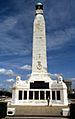
After the English Civil War, the Royal Citadel was built in 1666. It was meant to defend the port and train soldiers. You can take guided tours there in the summer. Further west is Smeaton's Tower, a lighthouse. It was built in 1759. The top two-thirds of the lighthouse were moved to Plymouth Hoe in 1877. You can climb it for great views of Plymouth Sound. Plymouth has 20 war memorials. Nine of them are on The Hoe. These include the Plymouth Naval Memorial and the Armada Memorial.
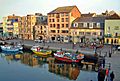
The old port area of Plymouth, called "Sutton," is now known as the Barbican. It has 100 listed buildings and many cobbled streets. The Pilgrim Fathers left for the New World in 1620 from near the Mayflower Steps in Sutton Pool. Also on Sutton Pool is the National Marine Aquarium. It has 400 marine species and Britain's deepest aquarium tank.
About 1 mile (1.6 km) upstream on the River Plym is the Saltram estate. It has a beautiful Jacobean and Georgian mansion.
On the northern edge of the city, Crownhill Fort is a well-preserved fort. It is open to the public.
To the west is Devonport, one of Plymouth's historic areas. The Devonport Heritage Trail helps visitors explore it.
Plymouth is a good base for visiting Dartmoor, the Tamar Valley, and the beaches of south-east Cornwall. Kingsand, Cawsand, and Whitsand Bay are popular spots.
The Roland Levinsky Building is a landmark at the University of Plymouth. It was designed by architect Henning Larsen and opened in 2008.
Beckley Point is Plymouth's tallest building. It is 78 meters (256 feet) tall with 20 floors. It was finished in 2018.
- Images of landmarks
-
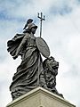
National Armada memorial (Britannia)
-
Naval War Memorial
-
The Parade, Barbican
-
The Mayflower Steps Memorial
-
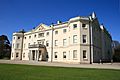
Saltram House remodelled by the architect Robert Adam
-
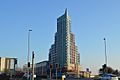
Beckley Point


.jpg)
Famous People from Plymouth

People from Plymouth are called Plymothians or, informally, Janners. A Janner is someone from the Plymouth area, especially in the Navy.
The famous sailor, Sir Francis Drake, was born nearby in Tavistock. He was also the mayor of Plymouth. He was the first Englishman to sail around the world. The Spanish called him El Draco ("The Dragon") because he raided their ships. His cousin, John Hawkins, was also from Plymouth.
Painter Sir Joshua Reynolds, who started the Royal Academy, was born and educated in nearby Plympton. William Cookworthy started his successful porcelain business in the city. He was friends with John Smeaton, who designed the Eddystone Lighthouse. Benjamin Robert Haydon, a painter of historical scenes, was born here in 1786. The naturalist William Elford Leach was born in Plymouth in 1791.
Famous athletes from Plymouth include swimmer Sharron Davies, diver Tom Daley, and footballer Trevor Francis. Other notable people include composer Ron Goodwin, journalist Angela Rippon, and comedian Dawn French. Actor Donald Moffat, who played the US Vice President in The Right Stuff, was born in Plymouth. Canadian actor Mark Holden was also born here.
Kevin Owen is an international TV news anchor who was born in Plymouth. The Cambridge spy Guy Burgess was born in Stoke, Plymouth.
Sister Cities
- Brest, France
- Gdynia, Poland
- Novorossiysk, Russia
- Plymouth, Massachusetts, United States
- San Sebastián, Spain
- Jiaxing, China
Freedom of the City
The following people, military units, and groups have received the Freedom of the City of Plymouth. This is a special honor given by the city.
Individuals Honored
- Mark Ormrod: November 22, 2021.
- Thomas Robert Daley: February 17, 2022.
- Lewis Pugh: March 27, 2023.
- Heather Knight: March 27, 2023.
Military Units Honored
- 42 Commando, RM: 1955.
- The Merchant Navy: March 22, 2009.
- The Rifles: September 25, 2010.
- The Ministry of Defence Hospital Unit Derriford: January 30, 2023.
Organizations and Groups Honored
- Veterans of the Falklands War: June 25, 2022.
- The Federation of Plymouth and District Ex-Services Associations: June 19, 2023.
See also
 In Spanish: Plymouth para niños
