
Tamar Bridge facts for kids
Quick facts for kids Tamar Bridge |
|
|---|---|

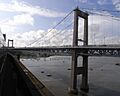
View from the Royal Albert Bridge, 2009
|
|
| Coordinates | 50°24′29.29″N 04°12′12.20″W / 50.4081361°N 4.2033889°W |
| Carries | A38 trunk road |
| Crosses | River Tamar |
| Locale | Saltash – Plymouth in southwest England |
| Characteristics | |
| Design | Suspension bridge |
| Longest span | 335 metres (1,099 ft) |
| History | |
| Constructed by | Cleveland Bridge & Engineering Company |
| Construction begin | July 1959 |
| Construction end | October 1961 |
| Opened | 26 April 1962 |
| Rebuilt | 1999–2001 |
| Statistics | |
| Toll | £2.00 (cars) eastbound only |
| Lua error in Module:Location_map at line 420: attempt to index field 'wikibase' (a nil value). | |
The Tamar Bridge is a huge suspension bridge in southwest England. It crosses the River Tamar, connecting Saltash, Cornwall with Plymouth, Devon. The bridge is 335 metres (1,099 ft) long and is part of the A38, a major road between the two counties. It runs right next to the Royal Albert Bridge, which is a railway bridge.
In the 20th century, more and more cars were on the roads. The old ferries, like the Saltash Ferry and Torpoint Ferry, couldn't handle all the traffic. So, people needed a new way to cross the river. The government didn't want to pay for it at first. Instead, Plymouth City Council and Cornwall County Council decided to fund the project themselves.
Building the bridge started in 1959. It opened in October 1961, and Queen Elizabeth The Queen Mother officially opened it in April 1962. Later, in 1999, the bridge needed to be rebuilt. This was because it couldn't support the weight of heavy trucks, as required by new rules. Workers added two new sections to the bridge while rebuilding the original part. The project finished in 2001, and Princess Anne opened it in April 2002. The extra sections are still used today, making the bridge even bigger.
You have to pay a toll to cross the bridge if you are driving east from Saltash to Plymouth. The Tamar Bridge is a famous landmark in the area. People have also used it for protests or to support charities.
Contents
Exploring the Tamar Bridge Location
.jpg)
The Tamar Bridge stretches over the River Tamar. On the west side, it's near Wearde, Saltash, and on the east side, it reaches Riverside, Plymouth. The middle part of the bridge is 335 metres (1,099 ft) long. It also has two side sections, each 114 metres (374 ft) long.
This bridge is part of the A38, a main road that goes across Cornwall and Devon. Right next to it, to the north, is the Royal Albert Bridge. That's a very important railway bridge designed by Isambard Kingdom Brunel, which opened in 1859. Both bridges are north of the Hamoaze, which is where the River Tamar flows into the sea. The Torpoint Ferry is also in this area.
The Tamar Bridge and Torpoint Ferry Joint Committee owns and takes care of the bridge. This committee is a group formed by Plymouth City Council and Cornwall County Council. The main part of the bridge has three lanes for cars. These lanes use a special system called tidal flow. This means the direction of traffic in some lanes can change to help cars move better during busy times.
There are also two outer lanes. The one on the north side is for local cars coming from Saltash. The one on the south side is for people walking or riding bikes. This south lane could be used for more cars in the future if needed. If that happens, other ways for walkers and cyclists to cross, like a special ferry or a cable car, might be built.
Understanding Bridge Tolls
To cross the Tamar Bridge, you pay a toll if you are driving east from Saltash to Plymouth. For cars, the toll is £2.00. Larger trucks with 2, 3, or 4 axles pay more, from £4.90 to £11.00.
There's a special electronic device called the Tamar Tag. If you put this on your car window, you can pay half the normal toll. People walking, cycling, or riding motorcycles do not have to pay any toll. Drivers with disabilities can also apply for special discounts.
Building the Bridge
Why the Bridge Was Needed

For many years, people traveling between Saltash and Plymouth had two main choices. They could take a very long detour north to cross the river at Gunnislake New Bridge, which was built in 1520. Or, they could take a ferry across the Tamar. The Torpoint Ferry started in 1791 and is still used today. The Saltash Ferry also ran close to where the bridge is now.
These ferries were popular, but by the 1900s, there were too many cars for them to handle. People had been talking about building a bridge across the Tamar since the early 1800s. Ideas for a bridge were even discussed in Parliament in 1930.
In 1950, Cornwall County Council and Plymouth City Council started to seriously think about building a road bridge. The government wasn't very keen on the idea. They thought it would cost too much money, and there were other more urgent projects after World War II. But the two councils decided to pay for the whole project themselves. They planned to get the money back by charging tolls.
The plan for the bridge was officially approved in July 1957. Companies were asked to bid for the construction job in March 1959. A company from northeast England called Cleveland Bridge & Engineering Company won the bid in June.
How the Bridge Was Built

Work on the Tamar Bridge began in July 1959. The builders used a method called suspended construction. This involved building two tall concrete towers, each 67 metres (220 ft) high. Strong support cables were stretched over these towers. Then, hangers were attached to the cables, and sections of the road deck were brought by boat and lifted into place. The same company, Cleveland Bridge and Engineering, later used this method to build the first Severn Bridge.
The main part of the bridge was 1,848 feet (563 m) long. The two main support cables were each 2,200 feet (670 m) long and weighed a total of 850 tons. British Ropes Ltd. made these cables. The road deck had a concrete base covered with 20-millimetre (0.79 in) steel plates. On top of that was 200-millimetre (7.9 in) of regular road tarmac.
The road was designed to be 33 feet (10 m) wide, with three lanes for traffic. There were also extra 6 feet (1.8 m) wide paths on each side for people walking. The bridge was expected to handle about 20,000 vehicles every day. Each vehicle could weigh up to 38 tons. The bridge materials were chosen to match the colour of the nearby Royal Albert Bridge.
The bridge opened unofficially at 6 AM on October 24, 1961, when the construction barriers were removed. Queen Elizabeth The Queen Mother formally opened it on April 26, 1962. The total cost to build the bridge was £1.8 million. It was the first big suspension bridge built in the UK after World War II. It was also the longest suspension bridge in Britain at that time.
How the Bridge Operates
When the bridge first opened, the toll for cars was 3 shillings (15p) for a one-way trip. A return trip cost 4 shillings and 6 pence (22½p). For lorries, it was 14 shillings (70p) and £1 for a return. The Saltash Ferry closed down, but the Torpoint Ferry kept running. The same group manages both the bridge and the Torpoint Ferry, so they don't compete with each other.
By 1979, the car toll had gone up to 30p for a single trip. By 1995, it was £1, and it stayed that way until 2010 when it increased to £1.50. On November 19, 2019, the standard toll became £2.00.
In 1961, about 4,000 vehicles used the Tamar Bridge each day. This number grew a lot over the years. By 1998, during the morning rush hour, about 2,500 vehicles crossed every hour. On an average weekday, 38,200 vehicles crossed, and on a summer weekday, it was 42,900. In comparison, the Torpoint ferry could only carry a maximum of 300 vehicles per hour.
Making the Bridge Wider and Stronger

The original bridge was built to support vehicles weighing up to 38 tons. But around 1995, an inspection found it couldn't meet new European Union rules for vehicles up to 40 tons. It could only safely support vehicles weighing 17 tons. In 1991, a study looked into building a brand new Tamar crossing, but it was too expensive, costing around £300 million. The existing bridge couldn't be closed because over 40,000 vehicles used it every day.
The solution was to add two new lanes, like balconies, on each side of the bridge. Traffic could use these new lanes while the original road deck was replaced. Hyder Consulting designed this work, and the same company that built the original bridge did the construction. The rebuilding started in 1999. There was a small delay because many tourists came to Cornwall to see the Solar eclipse of 11 August 1999.
The new deck had 82 large panels, each measuring 6 metres (20 ft) by 15 metres (49 ft) and weighing 20 tons. The work finished in December 2001 and cost £34 million. The two extra lanes were kept to make the bridge bigger and handle more traffic. The completed bridge actually weighed 25 tons less than the original.
Princess Anne officially reopened the Tamar Bridge on April 26, 2002. This was exactly forty years after its first opening. It was the first suspension bridge in the world to be widened using these side extensions, called cantilevers. It was also the first suspension bridge in the world to be widened and strengthened while still being open to traffic.
This project won several awards, including the British Construction Industry Civil Engineering Award in 2002. It also won an award from the Institution of Civil Engineers and was a finalist for the Prime Minister's Better Public Building Award.
Bill Moreau, a chief engineer from New York, was very impressed. He visited the bridge after its reconstruction. He hoped that similar methods could be used on older bridges in New York, like the George Washington Bridge.
The Bridge's Importance
.jpg)
The Tamar Bridge is a well-known symbol of the local area. It's also a very important road link between Cornwall and the rest of England. Some people who want Cornwall to have more self-governance, like Wales and Scotland, say that crossing the Tamar Bridge feels like entering "a bit like a parallel universe."
In March 1998, after Europe's last tin mine in Cornwall closed, a group called the Cornish Solidarity Action Group (CSAG) protested. They asked drivers to pay the £1 toll in pennies. They hoped this would slow down toll collection and cause big traffic jams. The group believed Cornwall should get similar financial help from the government as other areas like South Wales.
On January 23, 2004, four protesters climbed onto a structure over the Tamar Bridge. They were from a group called Fathers 4 Justice, which supports fathers' rights in child custody cases. Their protest caused long traffic delays on both sides of the bridge during rush hour.
In 2012, local councillors were upset when the Olympic committee decided not to run the Olympic Torch across the Tamar Bridge. This was before the Olympics in London. One councillor said the handover should have been "one of the iconic moments of the whole torch relay in Cornwall." The organisers said it wasn't practical because it would mean closing the bridge.
Images for kids
-
View from the Royal Albert Bridge, 2009
-

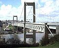
Traffic on the Tamar Bridge uses a tidal flow arrangement to reduce rush-hour congestion
-
The original Tamar Bridge in 1978, before its late-1990s reconstruction.
-
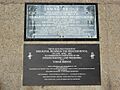
A set of plaques commemorating the original opening of the Tamar Bridge, and its reconstruction 40 years later
-
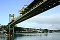
The Tamar Bridge during widening and strengthening work, 1999
-
The Cornish cross
See also
 In Spanish: Puente del Tamar para niños
