Hamoaze facts for kids
Quick facts for kids Hamoaze |
|
|---|---|

|
|
| Physical characteristics | |
| River mouth | Plymouth Sound 50°23′44″N 4°12′28″W / 50.39556°N 4.20778°W |
| Basin features | |
| Tributaries |
|
| Inland ports | HMNB Devonport |
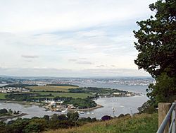
The Hamoaze is a special part of the River Tamar in England. It's an estuary, which means it's where the river meets the sea. The Hamoaze is found between where the River Lynher joins the Tamar and the Plymouth Sound.
Contents
What's in a Name?
The name Hamoaze first appeared in 1588. It probably came from a small creek that led to a place called Ham. This area was north of what is now the Devonport Dockyard. Later, the name Hamoaze was used for the whole main waterway. The "ose" part of the name might come from an old English word, "wāse." This word means 'mud' or 'ooze.' This makes sense because the creek had many mud-banks when the tide was low.
Important Waterway
The Hamoaze flows right past the Devonport Dockyard. This dockyard is one of the three main bases for the Royal Navy today. It's a very busy place where warships are built, repaired, and kept.
Staying Safe on the Water
Because so many large warships use the Hamoaze, it can be tricky for smaller boats. Many small watercraft also use the waterway. To keep everyone safe, a special person called the Queen's Harbour Master for Plymouth controls all the boat traffic. They make sure everyone follows the rules.
Towns and Villages
Several towns and villages are located along the banks of the Hamoaze.
Crossing the Hamoaze
There are two main ferry services that help people cross the Hamoaze:
- The Torpoint Ferry is a special chain ferry. It can carry vehicles like cars and trucks.
- The Cremyll Ferry is for passengers and cyclists only.
You can even find a street in Torpoint named after the Hamoaze!
See also
 In Spanish: Hamoaze para niños
 | Kyle Baker |
 | Joseph Yoakum |
 | Laura Wheeler Waring |
 | Henry Ossawa Tanner |

