Geographic coordinate system facts for kids
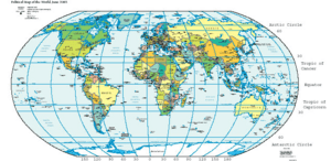
A geographical coordinate system is like a special grid drawn all over the Earth. It helps us find the exact spot of anything, from your school to the highest mountain. Every place on Earth can be described using a set of numbers called coordinates.
Contents
Finding Your Way with Latitude and Longitude
This system uses two main types of imaginary lines: latitude and longitude. Together, they create a unique address for every location.
- Latitude: These lines go around the Earth horizontally, like invisible belts. They tell you how far north or south a place is from the Equator. The Equator is a special line that circles the Earth exactly halfway between the North Pole and South Pole. It's like the Earth's waistline! Latitude is measured in degrees (°). The Equator is 0° latitude. The North Pole is 90° North, and the South Pole is 90° South. So, the further you are from the Equator, the bigger your latitude number will be.
- Longitude: These lines run vertically, from the North Pole to the South Pole. They tell you how far east or west a place is from the Prime Meridian. The Prime Meridian is another special line that passes through Greenwich, England. Longitude is also measured in degrees (°). The Prime Meridian is 0° longitude. Lines of longitude go up to 180° East and 180° West. These two lines meet at the International Date Line.
Understanding Degrees, Minutes, and Seconds
To be super precise, each degree of latitude and longitude is divided into 60 smaller parts called minutes ('). Each minute is then divided into 60 even smaller parts called seconds ("). This allows us to pinpoint locations very accurately. For example, the coordinates 34°15'12" N, 118°14'30" W tell us a very specific spot in Los Angeles, California. The "N" means it's North of the Equator, and "W" means it's West of the Prime Meridian.
Why Are Geographic Coordinates So Important?
Geographic coordinate systems are incredibly useful for many things in our daily lives.
- Navigation: Ships, airplanes, and even your car's GPS use these coordinates to know exactly where they are and where they need to go. Imagine trying to find your way across an ocean without them!
- Mapping: Cartographers, who are mapmakers, use these coordinates to create accurate maps. They help us see where countries, cities, mountains, and rivers are located.
- Science: Scientists use geographic coordinates to study the Earth. They can track weather patterns, monitor animal migrations, or pinpoint where a volcano erupted.
- Emergency Services: If someone needs help, like if they are lost, emergency responders can use coordinates from a GPS device to find them quickly.
- Land Surveying: Surveyors use these coordinates to measure and map land boundaries. This is important for building houses, roads, and other structures correctly.
A Brief History of Finding Our Place
The idea of using a grid to find places on Earth started a long time ago.
The ancient Greek scholar Eratosthenes of Cyrene is often given credit for inventing a geographic coordinate system around 200 BC. Later, another Greek scholar named Hipparchus improved this system. He found better ways to measure latitude using stars and longitude using lunar eclipses.
In the 2nd century AD, Ptolemy wrote a famous book called Geography. He used the Equator as the main line for latitude. His work was later translated into Arabic and helped mapmakers in the Arab world.
Much later, in 1884, many countries met at the International Meridian Conference in the United States. They agreed to use the Royal Observatory in Greenwich, England, as the 0° line for longitude. This helped everyone use the same reference point for maps and navigation.
Other Ways to Map the Earth
While latitude and longitude are the most common, there are other coordinate systems for special jobs. These systems might use different ways to show the Earth's curved surface on a flat map.
- UTM (Universal Transverse Mercator): This system divides the Earth into 60 zones. Each zone has its own special grid. It's often used for very detailed maps and land surveying.
- State Plane Coordinate Systems: These systems are made for specific states or regions. They help make maps very accurate for smaller areas.
- Geographic Information Systems (GIS): GIS uses coordinate systems to store and manage geographic information. This allows people to analyze and visualize data about the Earth, like where different types of plants grow or where roads are located.
Cool Facts About Coordinates
- The International Date Line isn't perfectly straight! It zigzags to avoid splitting countries or islands in half.
- The Earth isn't a perfect ball. It's slightly flattened at the poles and bulges a bit at the Equator. This small difference is important for very accurate coordinate measurements.
- GPS satellites orbit the Earth and send signals. Your GPS receiver uses these signals to figure out your exact latitude and longitude.
- Many online map services, like Google Maps, use geographic coordinate systems to show you locations and give directions.
- Being able to tell time accurately was super important for figuring out longitude at sea. Before good clocks, sailors had a very hard time knowing their exact east-west position.
See also
 In Spanish: Coordenadas geográficas para niños
 | Claudette Colvin |
 | Myrlie Evers-Williams |
 | Alberta Odell Jones |


