
GIS facts for kids
GIS stands for either Geographic Information Sciences or Geographic Information System. These are two different but connected ideas in geography. Geographic Information Sciences is a big field of study. It helps us understand information about places. A Geographic Information System (GIS) is a computer system. It's made to collect, store, change, look at, manage, and show all kinds of data about locations. It lets us study different "layers" of geographic information.
A GIS is like a smart map on a computer. It helps us capture and show places on Earth. It can display data in many ways on maps. Its main job is to help us look at groups of data. It helps us find correlations, which are connections, or patterns. For example, a map could use GIS to show how much trash is in one area. It could also show how many factories are there and what types they are. This helps us see if there's a link between factories and trash.
GIS can store lots of information about any location. It helps us learn about many different things in a place. You can tell the GIS where you want to look. You can use latitude and longitude coordinates. You can also use a postal code or an address. Then, GIS can give you details about the people in that area. This includes their income, how many people live there, and their education levels. It can also tell you about physical things. These include soil types, plants, water sources, and man-made things like buildings and roads.
Contents
What is GIS?
A Geographic Information System (GIS) is a powerful computer tool. It helps us work with maps and location data. Think of it as a digital map that can hold endless amounts of information. It's not just a flat picture. It's a smart system that understands where things are. It also knows how they relate to each other.
GIS helps us see the world in new ways. It takes information about places and puts it on a map. This makes it easier to understand complex problems. It can show us where things are happening. It also helps us see why they might be happening.
How Does GIS Work?
GIS collects data from many sources. This data can be about anything that has a location. For example, it could be about roads, rivers, or buildings. It could also be about people, animals, or weather. All this information is stored in a special database.
Once the data is in the system, GIS can do amazing things. It can combine different types of information. It can also analyze it to find patterns. This helps us make better decisions. For instance, city planners use GIS. They can decide where to build new schools or hospitals.
Layers of Information
One of the coolest things about GIS is using "layers." Imagine a stack of clear plastic sheets. Each sheet has different information drawn on it. One sheet might show all the roads. Another might show all the rivers. A third could show all the buildings. When you stack them up, you see everything together.
GIS works like this, but digitally. Each type of information is a separate layer. You can turn layers on or off. You can also change their order. This helps you focus on what you need to see. For example, you can see how roads connect to rivers. Or you can see where buildings are near parks.
What Can GIS Do?
GIS is used in many different fields. Scientists use it to study climate change. Businesses use it to find the best places for new stores. Emergency services use it to plan rescue routes. Even farmers use it to manage their crops.
It helps people answer questions like:
- Where is the best place to put a new fire station?
- How many people live within a mile of this park?
- Where are all the trees in our city?
- How has the coastline changed over the years?
Finding Patterns and Connections
GIS is excellent at finding hidden patterns. It can show connections that are hard to see otherwise. For example, in 1854, a doctor named John Snow used a map. He mapped where people got sick with cholera in London. He saw that many sick people lived near one water pump. This helped him figure out the disease was spreading through contaminated water. This was an early example of using location to solve a problem.
Today, GIS does this much faster and with more data. It can help track the spread of diseases. It can also help predict where natural disasters might happen. This allows people to prepare and stay safe.
Mapping the World Around Us
GIS helps us create detailed maps. These maps can show everything from tiny streets to entire continents. They can be flat, 2D maps. Or they can be amazing 3D models of mountains and cities. This helps us visualize the world in a realistic way.
Many apps on your phone use GIS. When you look up directions, that's GIS at work. When you see a map of nearby restaurants, that's also GIS. It helps us navigate and understand our surroundings every day.
Images for kids
-
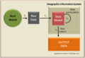
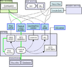
Basic GIS concept
-
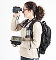
Example of hardware for mapping (GPS and laser rangefinder) and data collection (rugged computer). The current trend for geographical information system (GIS) is that accurate mapping and data analysis are completed while in the field. Depicted hardware (field-map technology) is used mainly for forest inventories, monitoring and mapping.
-
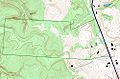
An example of use of layers in a GIS application. In this example, the forest-cover layer (light green) forms the bottom layer, with the topographic layer (contour lines) over it. Next up is a standing water layer (pond, lake) and then a flowing water layer (stream, river), followed by the boundary layer and finally the road layer on top. The order is very important in order to properly display the final result. Note that the ponds are layered under the streams, so that a stream line can be seen overlying one of the ponds.
-
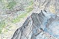
A traditional topographic map rendered in 3D
-
OGC standards help GIS tools communicate.


See also
 In Spanish: Sistema de información geográfica para niños
