
Global Positioning System facts for kids

A Global Positioning System, or GPS, is a special system that uses satellites in space to help you find your way around. It's like having a super helpful guide that works on land, in the air, and on water!
A GPS receiver is a device that tells you exactly where you are. It can also show how fast you're moving, which way you're going, and how high you are above the ground. Many GPS devices also have maps and information about different places. For example, GPS devices for cars often show road maps, hotels, restaurants, and gas stations. GPS for boats can show maps of harbors, marinas, shallow water, and waterways. There are also GPS devices made for flying, hiking, biking, and many other activities. You probably even have a GPS in your smartphone!
Most GPS devices can remember where you've been. They can also help you plan a trip. While you're traveling, a GPS can even guess how long it will take to reach your next stop.
Contents
How GPS Finds You

A GPS unit works by listening to radio signals from special satellites orbiting high above the Earth. There are 31 of these satellites, flying about 20,200 kilometers (12,550 miles) above us. Each satellite takes about 12 hours to circle the Earth once. From most places on Earth, a GPS unit can "see" signals from 6 to 12 satellites at the same time.
The Satellites and Their Clocks
Each GPS satellite has a super accurate atomic clock inside it. These clocks are checked and set very carefully by experts several times a day. The radio signals sent by the satellites contain important information. This includes the exact time the signal was sent and the satellite's exact position in space.
Calculating Your Position
Your GPS receiver gets these signals. It then figures out how long it took for each signal to travel from the satellite to your device. It does this by subtracting the time the signal was sent from the time it received it. This time difference, multiplied by the speed of light, tells your GPS how far away each satellite is.
The GPS unit then uses a bit of math called trigonometry. By knowing the exact position of several satellites and how far away each one is, your GPS can figure out your exact location on Earth. Usually, it needs signals from at least four satellites to do this accurately. A GPS receiver can calculate its position many times every second!
Most GPS devices that people buy are very accurate. They can tell you where you are within about 20 meters (66 feet) almost anywhere on Earth.
How GPS Measures Speed
Your GPS can also usually tell you how fast you're moving. Simpler GPS devices, like those in mobile phones, figure this out by comparing your current position to where you were a moment ago. More advanced GPS units, like those in airplanes, use something called the Doppler effect to measure speed very precisely.
The History of GPS
People have used radio systems to help with navigation since the middle of the 1900s. In the 1960s, scientists started experimenting with putting these radio transmitters on satellites.
Building the System
A new satellite navigation system, first called Navstar, was designed in the 1970s by the United States Air Force. At first, this system was only used by the U.S. military.
In 1983, President Ronald Reagan made a decision to allow everyone to use the system. However, at that time, the system was still quite small and not very useful for everyday people. For a while, the most accurate GPS signal was kept secret and only the military could use it. But in the 1990s, this secret signal was made available to everyone, and it became a permanent change around the year 2000.
GPS Devices Over Time
In the 1900s, most GPS receivers were separate devices with their own power and screen. Military GPS units back then often just showed geographic coordinates, or they would send the location information to another machine without showing it on a screen.
Today, most GPS receivers are built right into our mobile phones. Many are also found in watches, cars, and other gadgets. The GPS part in a mobile phone is usually small and might not be super powerful on its own. But phones also use signals from mobile phone towers and Wi-Fi to help them find your location even better. This is called "augmented GPS" or aGPS.
The Global Positioning System (GPS) is not the only system like this in the world.
- Russia has its own satellite navigation system called GLONASS.
- The European Union is building another system called Galileo, which is still being completed.
Images for kids
-

AFSPC Vice Commander Lt. Gen. DT Thompson presents Dr. Gladys West with an award as she is inducted into the Air Force Space and Missile Pioneers Hall of Fame.
-
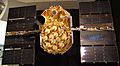
Unlaunched GPS block II-A satellite on display at the San Diego Air & Space Museum
-
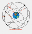
A visual example of a 24-satellite GPS constellation in motion with the Earth rotating. Notice how the number of satellites in view from a given point on the Earth's surface changes with time. The point in this example is in Golden, Colorado, USA (39°44′49″N 105°12′39″W / 39.7469°N 105.2108°W).
-
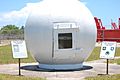
Ground monitor station used from 1984 to 2007, on display at the Air Force Space and Missile Museum.
-
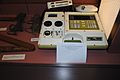
The first portable GPS unit, a Leica WM 101, displayed at the Irish National Science Museum at Maynooth.
-
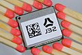
A typical OEM GPS receiver module measuring 15 by 17 millimeters (0.59 by 0.67 inches).
-
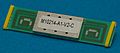
A typical GPS receiver with integrated antenna.
-

This antenna is mounted on the roof of a hut containing a scientific experiment needing precise timing.
-
Attaching a GPS guidance kit to a dumb bomb, March 2003.
-
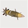
M982 Excalibur GPS-guided artillery shell.


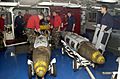
_bombs_in_the_forward_mess_decks.jpg)

See also
 In Spanish: GPS para niños
