
Navigation facts for kids

Navigation is all about knowing where you are and how to get to where you want to go. It's like having a superpower that helps you find your way, whether you're walking to a friend's house, sailing a ship, or even flying an airplane!
Contents
Imagine trying to find your way without any directions or a map. You might get lost! Navigation helps us avoid getting lost. It's super important for many reasons:
- Stay Safe: Knowing where you are and where you're headed helps you avoid dangers. This could be storms, rough ground, or getting lost in the wilderness.
- Reach Your Destination: Navigation makes sure you arrive at the right place. This could be a faraway country or just your local park.
- Explore New Places: With good navigation skills, you can bravely explore new areas. You can discover exciting things without fear of getting lost.
- Trade and Connect: For thousands of years, navigation has helped people travel. They could trade goods and connect with other cultures around the world.

People have been navigating for a very long time! Let's take a quick trip through history to see how navigation has changed.
In ancient times, people used their senses and nature to find their way. They watched the sun, moon, and stars to know directions. They also used landmarks like mountains, rivers, and coastlines as guides.
- Polynesian Navigators: The Polynesians were amazing sailors. They explored and settled islands across the Pacific Ocean. They used only their knowledge of the stars, ocean waves, and bird flight patterns. They even made "stick charts" from reeds and shells. These charts showed ocean swells and island locations.
- The Egyptians: The Egyptians used the Nile River as a main travel route. They created simple ways to map the river and the land around it.
Middle Ages: 500 AD to 1500 AD
During this time, new tools and methods were created. These made navigation much more accurate.
- The Compass: The compass was invented in China. It was later used by Europeans and changed navigation forever. It helped sailors find direction even when the sun and stars were hidden. The first compasses used a naturally magnetic rock called lodestone.
- The Astrolabe: The astrolabe was a tool used to measure how high the sun or stars were in the sky. This measurement helped sailors figure out their latitude. Latitude tells you how far north or south you are from the equator.
Age of Exploration: 1500 AD to 1800 AD
This was a time of huge discoveries. European explorers sailed to new lands all over the world.
- The Sextant: The sextant was an improved version of the astrolabe. It helped sailors measure angles more accurately. This led to much better latitude calculations.
- Accurate Maps: As explorers traveled, they made more detailed and correct maps. These maps helped future navigators plan their journeys. A famous mapmaker named Gerardus Mercator created a map style that is still used today.
Modern Era: 1800 AD to Today
In recent times, navigation has become super precise and smart. This is thanks to new technologies.
- The Chronometer: The chronometer was a very accurate clock. It helped sailors figure out their longitude. Longitude tells you how far east or west you are from the Prime Meridian. John Harrison, an English clockmaker, invented the first successful chronometer.
- Radio Navigation: Radio signals were used to help ships and airplanes find their position. Systems like LORAN (Long Range Navigation) used radio transmitters for navigation.
- GPS (Global Positioning System): GPS is a navigation system that uses satellites. It lets you find your exact location anywhere on Earth. It uses a network of satellites orbiting the Earth. These satellites send precise location data to GPS receivers.
Tools for Finding Your Way
Over the years, navigators have used many different tools. Here are some of the most important ones:
- Compass: A compass is a tool that shows direction. It has a magnetic needle that points towards magnetic north.
- Map: A map is a drawing of an area. It shows things like roads, rivers, and mountains. Maps help you plan your route and find landmarks.
- Chart: A chart is a special map used for navigating on water. It shows water depths, coastlines, and dangers in the water.
- GPS Receiver: A GPS receiver is a device that uses signals from GPS satellites to find its location. You can find GPS receivers in cars, airplanes, ships, and even smartphones.
- Sextant: This tool measures the angle between a sky object (like the sun or a star) and the horizon. This measurement helps you find your latitude.
- Chronometer: A very accurate clock used to figure out your longitude.
Today, navigation is more advanced than ever! Let's see how it works in different places:
On Land
When we drive, hike, or bike, we often use GPS devices or phone apps. These tools use GPS satellites to find our location. They also give us turn-by-turn directions. We can still use maps and compasses in places where there's no GPS signal.
At Sea
Sailors use a mix of GPS, charts, compasses, and radar to navigate. They also need to pay attention to weather, tides, and ocean currents.
In the Air
Pilots use GPS, radio navigation systems, and radar to fly airplanes. They also use maps and charts to plan their routes and avoid obstacles. Air traffic controllers help guide planes safely through the sky.
In Space
Spacecraft use very complex navigation systems. These help them travel to other planets and explore the universe. These systems use sensors, computers, and talk with ground control. This helps them know where the spacecraft is and where it's going.
- Latitude: How far north or south you are from the equator. It's measured in degrees. The equator is 0 degrees latitude. The North and South Poles are 90 degrees latitude.
- Longitude: How far east or west you are from the Prime Meridian. It's measured in degrees. The Prime Meridian is 0 degrees longitude. It runs through Greenwich, England.
- Bearing: The direction of an object or landmark. It's measured in degrees from north.
- Course: The direction you plan to travel.
- Speed: How fast something is moving. It's usually measured in miles per hour (mph) or knots (nautical miles per hour).
- Distance: How long a route or journey is.
- The word "navigation" comes from the word "navgatih" from the Sanskrit language.
- The Latin word navis means ship. So, navigation literally means "the art of ship mastery."
- Many animals have amazing navigation skills! Birds fly thousands of miles each year. They use the sun, stars, and Earth's magnetic field to guide them. Salmon return to the same rivers where they were born to lay eggs. They use their sense of smell to find their way. Sea turtles travel across entire oceans to lay their eggs on specific beaches.
Navigation is always changing and getting better. Scientists and engineers are working on new technologies. These will make navigation even more accurate and helpful. Here are some exciting things coming up:
- Better GPS: New GPS satellites will give us even more precise and reliable location data.
- Self-Driving Vehicles: Cars, trucks, and ships that drive themselves will use advanced navigation systems. These will help them operate safely and efficiently.
- Indoor Navigation: New tech is being made to help people navigate inside buildings. It uses sensors and wireless networks.
- Space Exploration: Super advanced navigation systems will be key for future trips to the Moon, Mars, and beyond.
Navigation is a fascinating and important field. It has shaped history and helped us explore the world. From ancient sailors to modern astronauts, people have always relied on navigation. As technology keeps growing, navigation will play an even bigger part in our lives.
Related pages
Images for kids
-
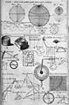
Table of geography, hydrography, and navigation, from the 1728 Cyclopaedia, or a Universal Dictionary of Arts and Sciences
-
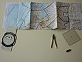
Manual navigation through Dutch airspace
-
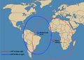
A celestial fix will be at the intersection of two or more circles.
-
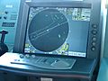
Radar ranges and bearings can be used to determine a position.


See also
 In Spanish: Navegación para niños
