
Google Maps facts for kids

Screenshot of Google Maps in a web browser
|
|
|
Type of site
|
Web mapping |
|---|---|
| Available in | Afrikaans, Azerbaijani, Indonesian, Malay, Bosnian, Catalan, Czech, Danish, German (Germany), Estonian, English (United States), Spanish (Spain), Spanish (Latin America), Basque, Filipino, French (France), Galician, Croatian, Zulu, Icelandic, Italian, Swahili, Latvian, Lithuanian, Hungarian, Dutch, Norwegian, Uzbek, Polish, Portuguese (Brazil), Portuguese (Portugal), Romanian, Albanian, Slovak, Slovenian, Finnish, Swedish, Vietnamese, Turkish, Greek, Bulgarian, Kyrgyz, Kazakh, Macedonian, Mongolian, Russian, Serbian, Ukrainian, Georgian, Armenian, Hebrew, Urdu, Arabic, Persian, Amharic, Nepali, Hindi, Marathi, Bengali, Punjabi, Gujarati, Tamil, Telugu, Kannada, Malayalam, Sinhala, Thai, Lao, Burmese, Khmer, Korean, Japanese, Simplified Chinese, Traditional Chinese |
| Owner | |
| Commercial | Yes |
| Registration | Optional, included with a Google Account |
| Launched | February 8, 2005 |
| Current status | Active |
| Written in | C++ (back-end), JavaScript, XML, Ajax (UI) |
Google Maps is a popular online tool and app created by Google. It helps you explore the world from your computer or phone. You can see satellite pictures, street maps, and even 360-degree views of streets with Street View. It also shows you live traffic and helps you plan trips for walking, driving, biking, or using public transport. As of 2020, over a billion people used Google Maps every month!
Google Maps started as a computer program made by brothers Lars and Jens Rasmussen, Stephen Ma, and Noel Gordon in Australia. In 2004, Google bought their company and turned it into an online service. After adding more features, Google Maps officially launched in February 2005. It uses special computer languages like JavaScript to work in your web browser. Google Maps also offers a way for other websites to use its maps. While a feature called Google Map Maker, which let users update maps, was stopped in 2017, people can still help improve Google Maps through the Google Local Guides program.
The satellite view in Google Maps shows a "top-down" or bird's-eye view. Most high-quality city images are taken from airplanes flying low, while other images come from satellites. These images are updated regularly. In August 2018, the computer version of Google Maps started showing the Earth as a 3D globe, which is a more accurate way to see our planet. You can still switch back to a flat 2D map if you prefer.
Google Maps for mobile phones first came out in 2006. Newer versions include GPS directions that tell you where to turn, and features to help you find parking. By 2013, it was the most popular app on smartphones. In 2017, the app had two billion users on Android phones.
Contents
- Discovering Google Maps' Past
- How Google Maps Works
- Getting Directions and Using Transit
- Seeing Traffic Conditions
- Exploring with Street View
- Amazing 3D Views
- Immersive View
- Landmark Icons and 45° Views
- Weather and Air Quality
- Lens in Maps
- Finding Businesses
- Indoor Maps
- Creating Your Own Maps with My Maps
- Becoming a Google Local Guide
- Seeing Earth Change with Timelapse
- Your Personal Timeline
- How Google Maps is Built
- Features That Are No Longer Available
- Google Maps on Your Phone
- Creative Uses of Google Maps
- Images for kids
- See also
Discovering Google Maps' Past
How Google Maps Started
Google Maps began as a computer program created by two Danish brothers, Lars and Jens Rasmussen, along with Noel Gordon and Stephen Ma. They worked at a company in Sydney, Australia, which Google bought in October 2004. The team then joined Google and turned their program into the online Google Maps we know today.
Around the same time, Google also bought another company called Keyhole. Keyhole had technology for showing geographic data, and parts of it were used to create Google Earth and improve Google Maps.
Early Years: 2005–2010

Google officially announced the launch of Google Maps on February 8, 2005.
In September 2005, after Hurricane Katrina caused a lot of damage, Google Maps quickly updated its satellite images of New Orleans. This helped people see how much of the city was flooded.
In 2006, an engineer found a way to make maps load faster on mobile phones by using fewer colors. This made the maps appear 20% quicker.
In November 2007, Google Maps for Mobile 2.0 was released. It included a "My Location" feature that could figure out where your phone was. It used GPS, Wi-Fi networks, and cell towers to pinpoint your spot on the map.
Google Maps launched in India in 2008. In September 2008, a Google Maps app was released for the new Android operating system.

Growing Up: 2011–2015
On April 19, 2011, a feature called Map Maker was added to Google Maps in America. This allowed anyone with a Google account to help edit and update the maps. This meant Google could get local map updates much faster.
In June 2012, Google started mapping the rivers and canals in the UK. They worked with the Canal and River Trust to help users plan trips along these waterways.

In December 2012, Google Maps became available as a separate app in the App Store. This happened after Apple decided to use its own map service on iPhones. Within two days, the Google Maps app was downloaded over ten million times!
In January 2013, Google Maps was updated to include a map of North Korea. By May 2013, Google Maps also recognized Palestine as a country.
In April 2014, Google Maps updated how it showed Crimea on the map. It reflected different ways people viewed its status, showing it differently depending on the country.
In April 2015, some unwanted changes appeared on Google Maps through Map Maker. As a result, Google temporarily stopped user editing worldwide to create new rules for approving changes and preventing future issues.
Modern Updates: 2016–Present
On June 27, 2016, Google updated its satellite imagery worldwide using data from Landsat 8. This brought much clearer and more detailed pictures. In August 2018, Google Maps changed its zoomed-out view to show a 3D globe, making the Earth look more realistic.
In January 2019, Google Maps added alerts for speed traps and speed cameras, based on reports from other users. In October 2019, it also added incident reporting, similar to the Waze app.
In December 2019, an Incognito mode was added. This lets users search for places without saving their activity to their Google accounts.
In February 2020, Google Maps got a new look for its 15th anniversary, including a new app icon that looked like the original one from 2005.
In September 2020, Google added a COVID-19 Layer to show the average number of cases in different areas. This feature was later removed in September 2022 due to less usage.
In January 2021, Google launched a new feature to display COVID-19 vaccination sites. They also updated the route planner to help drivers of electric vehicles find charging stations.
In June 2022, Google Maps added a layer to show air quality information for certain countries.
In February 2026, South Korea allowed Google to use more detailed map data, which improved navigation in the country.
How Google Maps Works
Getting Directions and Using Transit
Google Maps helps you plan your trips. It gives you directions for driving, using public transportation, walking, or biking. Google works with many public transport companies around the world to provide accurate bus, train, and subway information. The app can even show you your transit route in real-time.
Seeing Traffic Conditions

Since 2007, Google has shown traffic data as colored lines on roads. These colors tell you how fast vehicles are moving. Google collects this information by using anonymous location data from many phone users. You can choose in your phone's settings if you want to share your location data with Google Maps.
Exploring with Street View

On May 25, 2007, Google launched Google Street View. This feature lets you see 360-degree panoramic views of streets and locations. It started with just five cities in the U.S. and has grown to thousands of places worldwide. Google uses special cars with cameras to capture these images.
When Street View first came out, some people were worried about privacy. To address this, Google now blurs faces and license plates in the images automatically.

Google has also added unique Street View experiences, like exploring parts of the Great Barrier Reef underwater and even navigating inside the International Space Station!
Amazing 3D Views
In August 2018, Google Maps added 3D models of hundreds of cities from Google Earth into its satellite view. These models are created using special aerial photography techniques.
Immersive View
Immersive View is a cool feature that creates detailed 3D images of places and routes. It uses Street View and aerial photos, combined with smart computer programs, to show you what a location looks like. It can even predict things like weather and how busy a place might be. This feature launched in February 2023 for some cities and expanded to routes in October 2023.
Landmark Icons and 45° Views
Google added special icons for city attractions in October 2019. In December 2009, Google also introduced a 45-degree angle view, giving you a "bird's-eye view" of cities that's different from the straight-down satellite view.
Weather and Air Quality
In February 2024, Google Maps added a small weather icon to its mobile apps. This gives you quick access to weather and air quality index details for your location.
Lens in Maps
Lens in Maps uses your phone's camera and augmented reality to identify shops, restaurants, and other places around you. It shows you useful information like opening times, how busy a place is, and reviews, right on your screen. This feature expanded to many new cities in October 2023.
Finding Businesses

Google Maps gathers information about businesses from many sources. Business owners can also create and manage their own listings through "Google Business Profile." This helps them share important details like their address, phone number, and photos. Sometimes, businesses try to make their listings stand out more on Google Maps.
Indoor Maps
In March 2011, indoor maps were added to Google Maps. This allows you to navigate inside large buildings like airports, museums, shopping malls, and universities. You can even see different floors of a building.
Creating Your Own Maps with My Maps

My Maps is a feature launched in April 2007 that lets you create your own custom maps. You can add points, lines, shapes, notes, and pictures on top of Google Maps. You can use these maps for yourself or share them with friends.
Becoming a Google Local Guide
Google Local Guides is a program where volunteers help improve Google Maps. By adding reviews, photos, and correcting information (like if a place is wheelchair accessible), users earn points and badges. This program helps keep Google Maps accurate and useful for everyone.
Seeing Earth Change with Timelapse
Earth Timelapse, released in April 2021, lets you see how our planet has changed over the last 37 years. It combines millions of satellite images to show these changes over time.
Your Personal Timeline
If you share your location with Google, the Timeline feature summarizes where you've been each day on a map. It can even guess how you traveled between places and show photos you took at those locations. In June 2024, Google started storing this information directly on your device instead of on the web.
How Google Maps is Built

When you drag the map, new parts of the map are quickly downloaded and appear on your screen. When you search for a business, the results load in the background without reloading the whole page. Google Maps uses a lot of JavaScript to make everything work smoothly.
Map Data and Pictures
Google gets its map data from many different companies and sources around the world. The owner of the map data is usually listed at the bottom of the map. For example, street maps in Japan come from a company called Zenrin. Google regularly updates its maps, but sometimes the street maps might not perfectly match the satellite images, or the data might be a bit old. Google also has rules about showing certain locations, sometimes using older images for security reasons.
Using Google Maps on Other Websites
The Google Maps API (Application Programming Interface) is a tool that lets other website developers use Google Maps on their own sites. This means you might see Google Maps embedded on a local restaurant's website or a travel blog. It's a very popular tool for developers.
Google Maps in China
In China, Google Maps works with local partners and follows specific rules for map data. This means maps might look a bit different there compared to other parts of the world, for example, in how some borders are shown or what language is used.
Features That Are No Longer Available
Google Latitude
Google Latitude was a feature that let you share your location with friends. It was based on Google Maps and worked on mobile phones. This service was stopped in August 2013, but some of its features were later added directly into the Google Maps app.
Google Map Maker
Google Map Maker allowed users to directly improve the map by fixing directions, adding trails, or missing roads. This feature was available in many parts of the world. However, Google announced that Map Maker would be discontinued in March 2017.
Google Maps on Your Phone
Google Maps is available as a mobile app for both Android and iOS phones. The first mobile version came out in 2005. In 2007, it was even preloaded on the very first iPhone.
For a while, iPhones used Google Maps as their built-in map app. But in 2012, Apple created its own map service, Apple Maps. Many users found Apple Maps had problems at first. So, Google released its own Google Maps app for iPhones in December 2012, and it was downloaded over ten million times in just two days!
Mobile App Features
The Google Maps apps for iOS and Android have many great features. These include turn-by-turn directions, street view, and public transport information. You can also download maps of certain areas to use offline when you don't have internet access.
Newer updates have added features like helping you find parking spots and remembering where you parked your car. In 2019, the Android version introduced "Live View," which uses augmented reality to show directions right on the road through your phone's camera. Google Maps also won an award in 2020 for its easy-to-use design. In March 2021, a feature was added that lets users draw missing roads. In June 2022, the app started showing how much you'd have to pay in tolls for a route.
A special "Go" version of the app was released in January 2018 for lower-end devices. This version is designed to work well on phones with less power.
Creative Uses of Google Maps
Artists and writers have found creative ways to use Google Maps. For example, a German novel called Senghor on the Rocks uses Google Maps locations to tell its story.
Artists have also used Google Street View in their work. Some have created art from the interesting images captured by the Street View cars. Bands like group_inou and Arcade Fire have even made music videos using Google Street View backgrounds, sometimes showing viewers their own childhood homes!
Images for kids
-
Google Maps Beta in 2005
-
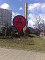
A monument in the shape of a Google Maps pin in the center of the city of Szczecin, Poland
-

Google Maps icon 2020
-
Screenshot of Google Maps with traffic option enabled
-
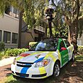
A Google Maps car at Googleplex, Mountain View
-
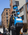
Google Maps Street View Trekker backpack being implemented on the sidewalk of the Hudson River Greenway in New York City
-
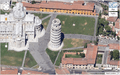
An example of the Leaning Tower of Pisa in the 45° view
-
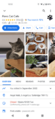
A business listing in Google Maps showing opening times, reviews and photos. This screenshot is from the Android mobile app.
-
Google My Maps
-
A split-view screenshot of Google Maps. In the bottom half Street Maps is shown, while in the top half Street View is shown. A user can zoom in and out of either of them independently of the zoom level of each.
-
Screenshot of Google Maps on Android 14 in dark mode


.svg)
See also
 In Spanish: Google Maps para niños
- Azure Maps
- Apple Maps
- Bing Maps
- Comparison of web map services
- GeoGuessr
- Here WeGo
- MapQuest
- OpenStreetMap
- Organic Maps
- Terravision
- Wikiloc, a mashup that shows trails and waypoints on Google Maps
- Wikimapia, a mashup combining Google Maps and a wiki aimed at "describing the whole planet earth"
- Yandex Maps, popular in Russia and CIS
