
Tokyo facts for kids
Quick facts for kids
Tokyo
東京都
|
|||||
|---|---|---|---|---|---|
| Tokyo Metropolis | |||||
|
|
|||||
|
|||||
| Nicknames:
The Big Mikan
|
|||||
| Anthem: "Tokyo Metropolitan Song" (東京都歌, Tōkyō-to Ka) |
|||||

Location within Japan
|
|||||
| Country | Japan | ||||
| Region | Kantō | ||||
| Island | Honshu | ||||
| Capital | Tokyo (de facto; de jure: Shinjuku) | ||||
| Divisions | 23 special wards, 26 cities, 1 district, and 4 subprefectures | ||||
| Government | |||||
| • Body | Tokyo Metropolitan Government | ||||
| Area | |||||
| • Total | 2,194 km2 (847 sq mi) | ||||
| • Metro | 13,452 km2 (5,194 sq mi) | ||||
| Area rank | 45th in Japan | ||||
| Highest elevation | 2,017 m (6,617 ft) | ||||
| Lowest elevation | 0 m (0 ft) | ||||
| Population
(2024)
|
|||||
| • Total | 14,187,176 | ||||
| • Rank | 1st in Japan | ||||
| • Density | 6,363/km2 (16,480/sq mi) | ||||
| • Urban | 39,105,000 | ||||
| • Metro | 41,000,000 | ||||
| • Metro density | 3,050/km2 (7,890/sq mi) | ||||
| • Dialects |
|
||||
| Demonym(s) | Tokyoite | ||||
| GDP | |||||
| • Total | JP¥109.692 trillion (US$1.027 trillion) (2020) |
||||
| • Metro | JP¥222.129 trillion (US$2.084 trillion) (2020) |
||||
| Time zone | UTC+09:00 (Japan Standard Time) | ||||
| ISO 3166-2 |
JP-13
|
||||
| Flower | Yoshino cherry | ||||
| Tree | Ginkgo | ||||
| Bird | Black-headed gull | ||||

_(cropped).jpg)


Tokyo (pronounced toe-key-oh), officially called the Tokyo Metropolis, is the capital city of Japan. It is one of the largest and busiest cities in the world. Over 14 million people live here, making it the second most populated capital city globally. The larger Greater Tokyo Area, which includes Tokyo and nearby areas, is home to 41 million people. This makes it the most populated metropolitan area on Earth!
Tokyo is located on the central coast of Honshu, Japan's biggest island, right by Tokyo Bay. It is Japan's main center for business and is where the Japanese government and the Emperor of Japan are located. The Tokyo Metropolitan Government manages the city. It includes 23 special areas (like mini-cities), many towns and suburbs in the west, and two groups of islands far out in the Pacific Ocean. Even though many people think of Tokyo as just one city, its government works more like a prefecture (a large region) since 1943.
Long ago, before the 1600s, Tokyo was a small fishing village called Edo. It became important in 1603 when it became the center of the Tokugawa shogunate, a military government. By the mid-1700s, Edo was one of the world's biggest cities. In 1868, after the Meiji Restoration, the emperor moved his capital from Kyoto to Edo, and the city was renamed Tokyo, meaning "Eastern Capital."
Tokyo has faced many challenges. In 1923, a huge earthquake, the Great Kantō earthquake, caused a lot of damage. Later, during World War II, the city was badly bombed. But Tokyo quickly rebuilt and grew, becoming a major part of Japan's amazing economic growth after the war. Today, Tokyo is home to many of the world's largest companies.
Tokyo was the first city in Asia to host the Summer Olympics and Paralympics in 1964, and again in 2021. It is a global hub for research and education, with many top universities like the University of Tokyo. Tokyo Station is the main hub for Japan's famous high-speed train network, the Shinkansen. Shinjuku Station is the busiest train station in the world! Tokyo also has the world's tallest tower, Tokyo Skytree, and Asia's oldest underground metro line, the Tokyo Metro Ginza Line, which opened in 1927.
Tokyo's economy is huge, making up a big part of Japan's total economic output. It is the second-largest city economy in the world, after New York. Tokyo is considered an "Alpha+ city" by global researchers, meaning it's a very important world city. It's also known as one of the safest and most livable cities in the world.
Understanding the Name: Tokyo's Meaning
| Tokyo | |||||||
|---|---|---|---|---|---|---|---|
.svg)
Tōkyō in kanji
|
|||||||
| Japanese name | |||||||
| Kanji | 東京 | ||||||
| Hiragana | とうきょう | ||||||
| Katakana | トウキョウ | ||||||
|
|||||||
Tokyo was first known as Edo. This name came from two Japanese characters meaning "cove" and "entrance" or "gate." It described the village's location where the Sumida River met Tokyo Bay.
In 1868, when the Meiji Restoration happened, the city's name changed to Tokyo. This new name means "Eastern Capital." It was chosen because the city became the new capital of Japan, following an old Asian tradition of including the word "capital" in the name of the capital city. For example, other cities like Kyoto and Beijing also have "capital" in their names.
Tokyo's Journey Through Time
From Fishing Village to Shogun's Seat (Before 1869)

Tokyo started as a small village called Edo. It was first protected by the Edo clan in the late 1100s. Later, in 1457, a warrior named Ōta Dōkan built Edo Castle to defend the area.
In 1590, Tokugawa Ieyasu took control of the Kantō region and made Edo his base. When he became the shōgun (the real ruler of Japan) in 1603, Edo became the center of the country's government. Even though the Emperor lived in Kyoto, the shogunate ruled from Edo.
During the Edo period, the city was very peaceful. This allowed Edo to grow into one of the world's largest cities, with over a million people by the 1700s. The city often rebuilt after fires and earthquakes.
This peaceful time ended in 1853 when American Commodore Matthew C. Perry arrived. He forced Japan to open its ports to foreign trade. This led to higher prices and social unrest. Eventually, supporters of the Emperor overthrew the shogunate in 1867. In 1868, Edo Castle was handed over to the Emperor's forces.
Modern Tokyo Takes Shape (1869–1941)


After the shogunate fell, the Emperor became the true ruler of Japan. In September 1868, Edo was renamed Tokyo (Eastern Capital). Emperor Meiji moved there in 1869, making it the official imperial capital. The old Edo Castle became the Imperial Palace.
Tokyo quickly modernized. Government offices moved there, and Japan's first railway line opened in 1872, connecting Tokyo to Yokohama. Important places like Ueno Park (1873) and the University of Tokyo (1877) were also established. The City of Tokyo was officially created in 1889.

On September 1, 1923, the Great Kanto Earthquake hit Tokyo. The earthquake and the fires that followed killed about 105,000 people. This disaster led to new building rules, encouraging stronger, earthquake-proof concrete buildings. The first underground railway line in Asia, the Tokyo Metro Ginza Line, opened in 1927.
In the 1930s, Japan faced economic problems and political unrest. This led to the military gaining more control, and Japan joined World War II as an Axis power. Tokyo lost its chance to host the 1940 Summer Olympics. On December 8, 1941, Japan attacked Pearl Harbor, bringing the country into the war.
War and Rebuilding (1942–1972)

In 1943, Tokyo City and Tokyo Prefecture combined to form the Tokyo Metropolis. This helped manage the city better during wartime.
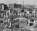
Tokyo was attacked for the first time in 1942 by the Doolittle Raid. Large-scale bombings by Allied forces began in late 1944. These bombings, especially in 1945, killed between 75,000 and 200,000 people and destroyed more than half of the city. The worst night was March 9–10, 1945, when firebombs destroyed a large part of the city, killing 100,000 people. Many historic buildings were lost. Tokyo's population dropped from 6.7 million to less than 2.8 million during the war.

After the war, Tokyo became the headquarters for the Allied forces who managed Japan for six years. In 1947, Tokyo's 35 special areas were reorganized into the current 23 wards.
Tokyo began to grow rapidly after 1950. The city's Metro and railway networks expanded greatly. In 1964, the world's first high-speed railway, the Shinkansen, opened between Tokyo and Osaka. The same year, Tokyo hosted the 1964 Summer Olympics, the first in Asia. This period saw the city transform from war ruins into a modern metropolis. Skyscrapers began to appear, starting with the Kasumigaseki Building in 1968.
Tokyo Today (1973–present)

Even after an oil crisis in 1973 slowed Japan's economy, Tokyo continued to develop as the country's main center. In 1978, Narita International Airport opened as the new main gateway to the city. The West Shinjuku area became a new business district with many tall skyscrapers.
In the late 1980s, Japan experienced an "asset price bubble," where land and stock prices soared. The value of the Tokyo Imperial Palace was once estimated to be more than the entire state of California! The Tokyo Stock Exchange became the largest in the world.

After the bubble burst in the 1990s, Japan faced economic challenges. However, Tokyo still saw new building projects like Odaiba, a man-made island that is now a popular shopping and entertainment area.
On September 7, 2013, Tokyo was chosen to host the 2020 Summer Olympics. This made it the first Asian city to host the Olympics twice. Due to the COVID-19 pandemic, the games were postponed and held in 2021.
Tokyo's Location and Weather
Where is Tokyo?
The main part of Tokyo is located northwest of Tokyo Bay. It stretches about 90 kilometers (56 miles) from east to west and 25 kilometers (16 miles) from north to south. Its average height above sea level is 40 meters (130 feet). Tokyo is bordered by Chiba Prefecture to the east, Yamanashi to the west, Kanagawa to the south, and Saitama to the north.
Tokyo also includes two chains of islands in the Pacific Ocean to the south: the Izu Islands and the Ogasawara Islands. These islands stretch over 1,000 kilometers (620 miles) from the mainland. Because of these islands and the mountains in the west, Tokyo's population density numbers don't show how crowded the city areas truly are.
Tokyo's Climate and Seasons
Tokyo has a humid subtropical climate. This means it has hot, humid summers and mild to cool winters with some cold periods. The warmest month is August, with an average temperature of 26.9°C (80.4°F). The coolest month is January, averaging 5.4°C (41.7°F). The highest temperature ever recorded was 39.5°C (103.1°F) in July 2004. The lowest was -9.2°C (15.4°F) in January 1876.
Tokyo gets about 1,600 millimeters (63 inches) of rain each year, with more rain in summer and less in winter. Snowfall is rare but happens almost every year. Typhoons (strong storms) affect Tokyo every year, but most are not very strong.
| Climate data for Kitanomaru Park, Chiyoda, Tokyo (1991–2020 normals, extremes 1875–present) | |||||||||||||
|---|---|---|---|---|---|---|---|---|---|---|---|---|---|
| Month | Jan | Feb | Mar | Apr | May | Jun | Jul | Aug | Sep | Oct | Nov | Dec | Year |
| Record high °C (°F) | 22.6 (72.7) |
24.9 (76.8) |
28.1 (82.6) |
29.2 (84.6) |
32.6 (90.7) |
36.4 (97.5) |
39.5 (103.1) |
39.1 (102.4) |
38.1 (100.6) |
32.6 (90.7) |
27.5 (81.5) |
24.8 (76.6) |
39.5 (103.1) |
| Mean daily maximum °C (°F) | 9.8 (49.6) |
10.9 (51.6) |
14.2 (57.6) |
19.4 (66.9) |
23.6 (74.5) |
26.1 (79.0) |
29.9 (85.8) |
31.3 (88.3) |
27.5 (81.5) |
22.0 (71.6) |
16.7 (62.1) |
12.0 (53.6) |
20.3 (68.5) |
| Daily mean °C (°F) | 5.4 (41.7) |
6.1 (43.0) |
9.4 (48.9) |
14.3 (57.7) |
18.8 (65.8) |
21.9 (71.4) |
25.7 (78.3) |
26.9 (80.4) |
23.3 (73.9) |
18.0 (64.4) |
12.5 (54.5) |
7.7 (45.9) |
15.8 (60.4) |
| Mean daily minimum °C (°F) | 1.2 (34.2) |
2.1 (35.8) |
5.0 (41.0) |
9.8 (49.6) |
14.6 (58.3) |
18.5 (65.3) |
22.4 (72.3) |
23.5 (74.3) |
20.3 (68.5) |
14.8 (58.6) |
8.8 (47.8) |
3.8 (38.8) |
12.1 (53.8) |
| Record low °C (°F) | −9.2 (15.4) |
−7.9 (17.8) |
−5.6 (21.9) |
−3.1 (26.4) |
2.2 (36.0) |
8.5 (47.3) |
13.0 (55.4) |
15.4 (59.7) |
10.5 (50.9) |
−0.5 (31.1) |
−3.1 (26.4) |
−6.8 (19.8) |
−9.2 (15.4) |
| Average precipitation mm (inches) | 59.7 (2.35) |
56.5 (2.22) |
116.0 (4.57) |
133.7 (5.26) |
139.7 (5.50) |
167.8 (6.61) |
156.2 (6.15) |
154.7 (6.09) |
224.9 (8.85) |
234.8 (9.24) |
96.3 (3.79) |
57.9 (2.28) |
1,598.2 (62.92) |
| Average snowfall cm (inches) | 4 (1.6) |
4 (1.6) |
0 (0) |
0 (0) |
0 (0) |
0 (0) |
0 (0) |
0 (0) |
0 (0) |
0 (0) |
0 (0) |
0 (0) |
8 (3.1) |
| Average precipitation days (≥ 0.5 mm) | 5.3 | 6.1 | 10.3 | 10.9 | 11.1 | 12.8 | 12.0 | 9.4 | 12.3 | 11.8 | 8.2 | 5.8 | 116.0 |
| Average relative humidity (%) | 51 | 52 | 57 | 62 | 68 | 75 | 76 | 74 | 75 | 71 | 64 | 56 | 65 |
| Average dew point °C (°F) | −5 (23) |
−4 (25) |
1 (34) |
8 (46) |
13 (55) |
18 (64) |
22 (72) |
23 (73) |
19 (66) |
12 (54) |
6 (43) |
−1 (30) |
9 (49) |
| Mean monthly sunshine hours | 192.6 | 170.4 | 175.3 | 178.8 | 179.6 | 124.2 | 151.4 | 174.2 | 126.7 | 129.4 | 149.8 | 174.4 | 1,926.7 |
| Percent possible sunshine | 61 | 56 | 47 | 45 | 41 | 30 | 34 | 42 | 34 | 37 | 48 | 57 | 44 |
| Average ultraviolet index | 2 | 3 | 5 | 7 | 9 | 10 | 10 | 9 | 7 | 5 | 3 | 2 | 6 |
| Source 1: Japan Meteorological Agency | |||||||||||||
| Source 2: Weather Atlas (UV), Time and Date (dewpoints, 1985–2015) | |||||||||||||
Tokyo's climate has become noticeably warmer since records began in 1876.
Dealing with Natural Disasters
Earthquakes in Tokyo

Tokyo is located near where three Earth plates meet. This means it experiences many small earthquakes. These quakes can make the city sway, but they rarely cause much damage. People who live in Tokyo are used to feeling hundreds of these small quakes (magnitudes 4–6) each year.
Tokyo has been hit by very strong earthquakes in the past, like in 1703, 1855, and 1923. The 1923 earthquake, with an estimated magnitude of 7.9, killed over 100,000 people. This was the last time a major quake directly hit the city.
Volcanic Threats
.jpg)
Mount Fuji is about 100 kilometers (62 miles) southwest of Tokyo. There is a low chance of it erupting. The last time it erupted was in 1707. During that eruption, ash fell on parts of Tokyo. If Mount Fuji were to erupt again and the wind blew towards Tokyo, even a small amount of ash could cause power outages and stop trains.
Protecting Tokyo from Floods

Tokyo is on a flat plain with many rivers that can swell during heavy rains and typhoons. Major rivers include the Edogawa and Arakawa. In the past, floods caused by typhoons, like Typhoon Kathleen in 1947, destroyed many homes and caused deaths.
To prevent future disasters, the Japanese government invested a lot of money in building dams, levees, and tunnels.

Tokyo now has the world's largest underground floodwater diversion system, called the Metropolitan Area Outer Underground Discharge Channel (MAOUDC). It took 13 years to build and was finished in 2006. This system of tunnels and huge tanks collects excess water from rivers during floods and drains it into the Edo River. This protects low-lying areas of Tokyo from flooding.
Tokyo's Buildings and Architecture
Tokyo's buildings are very diverse. Most of the structures you see today were built in the last hundred years. This is because the city was destroyed twice: first by the 1923 Great Kanto Earthquake and then by bombings in World War II.
Old Buildings (Before 1868)
_2023-09-10.jpg)
The oldest known building in Tokyo is Shofukuji, built in 1407. Many buildings from the Edo period (1603–1868) still exist, even after fires and wars. The Tokyo Imperial Palace, which was once Edo Castle, has many old gates and towers.
Many temples and shrines from this time also remain. For example, the Ueno Toshogu temple still has its original 1651 building. Some beautiful gardens that once belonged to powerful feudal lords are now open to the public, like Hamarikyu and Koishikawa Korakuen.

Modern Buildings (1869–1945)


During the Meiji era, Tokyo rapidly modernized its architecture. Many grand brick buildings were constructed, though the 1923 earthquake showed their weakness. Some brick survivors include Tokyo Station (1914) and the Ministry of Justice building (1895).


The 1923 earthquake led to a new era of concrete architecture. Many reinforced concrete buildings from this time still stand, such as the Meiji Insurance Headquarters (1934) and the National Diet Building (1920-1936).
Contemporary Buildings (1946–Present)


Since the 1960s, when height limits were removed, skyscrapers have become common in Tokyo. As of May 2024, there are over 180 buildings taller than 150 meters (492 feet). The Tokyo Tower (333m) and Tokyo Skytree (634m) are famous for their observation decks. The Tokyo Skytree is the tallest tower in the world!
Famous architects like Kenzo Tange designed many important modern buildings, including the Yoyogi National Gymnasium (1964) and the Tokyo Metropolitan Government Building (1991). Other well-known modern buildings include the Tokyo Dome and Roppongi Hills.
.JPG)
People and Culture of Tokyo
Who Lives in Tokyo?
| Historical population | ||
|---|---|---|
| Year | Pop. | ±% |
| 1920 | 3,699,428 | — |
| 1925 | 4,485,144 | +21.2% |
| 1930 | 5,408,678 | +20.6% |
| 1935 | 6,369,919 | +17.8% |
| 1940 | 7,354,971 | +15.5% |
| 1945 | 3,488,284 | −52.6% |
| 1950 | 6,277,500 | +80.0% |
| 1955 | 8,037,084 | +28.0% |
| 1960 | 9,683,802 | +20.5% |
| 1965 | 10,869,244 | +12.2% |
| 1970 | 11,408,071 | +5.0% |
| 1975 | 11,673,554 | +2.3% |
| 1980 | 11,618,281 | −0.5% |
| 1985 | 11,829,363 | +1.8% |
| 1990 | 11,855,563 | +0.2% |
| 1995 | 11,773,605 | −0.7% |
| 2000 | 12,064,101 | +2.5% |
| 2005 | 12,576,601 | +4.2% |
| 2010 | 13,159,388 | +4.6% |
| 2015 | 13,515,271 | +2.7% |
| 2020 | 13,982,112 | +3.5% |
As of 2023, over 14 million people live in Tokyo. During the day, the population grows by more than 2.5 million as people come in for work and school. The central areas like Chiyoda, Chuo, and Minato have many more people during the day than at night.


The most populated areas in Tokyo are Setagaya, Nerima, and Ota. Some of the least populated areas are remote island villages like Aogashima.
Tokyo is a relatively young region in Japan, with an average age of 45.5 years old in 2021. This is younger than the national average.
People from Other Countries
As of January 2024, Tokyo had over 647,000 foreign residents. Many people from China, South Korea, Vietnam, the Philippines, Nepal, Taiwan, and the United States live there. Tokyo's foreign population has grown a lot since the COVID-19 pandemic.
Languages and Dialects
Japanese is the main language spoken in Tokyo. Traditionally, there were two main dialects: the Yamanote dialect, spoken by upper-class families, and the Shitamachi dialect, spoken by working-class people. The standard Japanese pronunciation is mostly based on the Yamanote accent. However, these differences have become less clear over the years as many people have moved to Tokyo from other parts of Japan.
On some of Tokyo's islands, like Hachijojima, people speak the Hachijō dialect, which is very old. In the Ogasawara Islands, a mix of English and Japanese, called Bonin English, is spoken because of the islands' unique history with people from many different backgrounds.
Tokyo's Economy and Business


Tokyo's economy is huge! In 2021, its total economic output was about US$1.04 trillion, making up over 20% of Japan's entire economy. The biggest parts of Tokyo's economy are wholesale and retail trade, real estate, and technology. Agriculture and fishing make up a very small part. The Greater Tokyo Area has the second-largest city economy in the world, after New York.
Tokyo's main business areas are in four central wards: Chiyoda (Marunouchi), Chuo (Nihombashi), Minato (Shimbashi), and Shinjuku (West Shinjuku).
In 2023, 29 of the world's 500 largest companies had their headquarters in Tokyo. This is the second-highest number for any city globally. Tokyo used to be known as the most expensive city in the world. However, due to economic changes, living costs in Tokyo are now more affordable compared to places like New York City. In 2024, Tokyo had the third-highest number of millionaires in the world.
Tokyo as a Financial Hub

Tokyo is a major international center for finance. It is home to the headquarters of many of the world's largest banks and insurance companies. It's also a hub for Japan's transportation, publishing, electronics, and broadcasting industries. After World War II, many big companies moved their main offices to Tokyo to be closer to the government.

Tokyo became a leading global financial center in the 1960s. It is considered one of the three "command centers" for the world economy, along with New York City and London. In 2020, Tokyo was ranked as the fourth most competitive financial center globally. Major banks like Mitsubishi UFJ, Sumitomo-Mitsui, and Mizuho are all based in Tokyo.
The Tokyo Stock Exchange is Japan's largest stock exchange and one of the top five largest in the world.
Media and Communication in Tokyo


Because Tokyo is Japan's cultural, political, and economic center, it has the largest media industry in the country. Most national media companies, like the public broadcaster NHK and major TV stations (TBS, Nippon Television, Fuji Television, TV Asahi), are based here. Many big newspaper companies and publishers also have their main offices in Tokyo.
Tokyo is also a major hub for creating anime. Many famous anime studios, such as Studio Ghibli and MAPPA, are located in the western part of the city.
Tourism in Tokyo

In 2019, tourism brought in a lot of money for Tokyo, with over 15 million foreign visitors.
Some of the most visited places in Tokyo include:
- Shibuya: Famous for its busy Shibuya Crossing and the Hachiko statue.
- Shinjuku: Home to Kabukicho (a nightlife district) and Shinjuku Gyoen (a beautiful garden).
- Ginza: A high-end shopping district with luxury stores and the Kabukiza theater.
- Asakusa: Known for the historic Sensoji Temple and views of the Tokyo Skytree.
- Akihabara: A hub for electronics and anime culture.
- Ueno: Features the National Museum, National Science Museum, and Ueno Zoo.
- Harajuku/Omoesando: Famous for youth fashion, street culture, and the Meiji Shrine.
- Roppongi: Has many art museums and tall buildings like Roppongi Hills.
Modern attractions include the Tokyo Skytree, which offers amazing views of the city. Odaiba, a man-made island, has shopping, dining, and entertainment like the teamLab Planets digital art museum. The Tokyo Disney Resort (with Tokyo Disneyland and Tokyo DisneySea) is also a major attraction, though it's actually located just outside Tokyo in Chiba.
Food in Tokyo
Tokyo is famous for its amazing food. In 2007, the Michelin Guide gave 191 stars to Tokyo restaurants, which was twice as many as Paris! As of 2017, 12 restaurants in Tokyo had the highest rating of three stars.
Recreation and Parks

For outdoor activities, you can visit Okutama and Mount Takao for hiking. Kasai Seaside Park offers coastal fun. Ueno Park is famous for its cherry blossoms, museums, and zoo. Inokashira Park has a pond and a zoo, and is near the Ghibli Museum.
Tokyo has many beautiful traditional Japanese gardens, some of which used to belong to noble families. These include Shinjuku Gyoen National Garden and Koishikawa Korakuen Garden.
National Parks in Tokyo
A large part of Tokyo's land is protected as Natural Parks. These include the Chichibu Tama Kai, Fuji-Hakone-Izu, and Ogasawara National Park. The Ogasawara National Park is even a UNESCO World Heritage Site!
Sports in Tokyo


Tokyo is a big center for sports. It has two professional baseball teams: the Yomiuri Giants (who play at the Tokyo Dome) and the Tokyo Yakult Swallows. The Japan Sumo Association is based in Tokyo at the Ryōgoku Kokugikan arena, where three major sumo tournaments are held each year.
Soccer clubs like F.C. Tokyo and Tokyo Verdy play at Ajinomoto Stadium. Rugby teams are also popular.
Tokyo hosted the 1964 Summer Olympics, becoming the first Asian city to do so. The city has many world-class sports venues and often hosts national and international events for basketball, volleyball, tennis, swimming, marathons, rugby, judo, and karate. Tokyo was also chosen to host the 2020 Summer Olympics and Paralympics, which took place in 2021 due to the COVID-19 pandemic.
Tokyo's Global Connections
Tokyo is a founding member of the Asian Network of Major Cities 21 and the C40 Cities Climate Leadership Group, which focuses on climate action.
Sister Cities and States
Tokyo has special "twinning" or friendship agreements with 12 cities and states around the world. These include:
- New York City, United States (since 1960)
- Beijing, China (since 1979)
- Paris, France (since 1982)
- New South Wales, Australia (since 1984)
- Seoul, South Korea (since 1988)
- Jakarta, Indonesia (since 1989)
- São Paulo State, Brazil (since 1990)
- Cairo, Egypt (since 1990)
- Moscow, Russia (since 1991)
- Berlin, Germany (since 1994)
- Rome, Italy (since 1996)
- London, United Kingdom (since 2015)
International Research and Science
Tokyo is a global hub for science and research. The University of Tokyo and other universities in the city work with many international institutions. They partner with universities like Harvard, Yale, Stanford, and MIT in the United States, as well as Oxford University in the UK and Tsinghua University in China. The United Nations University, which is the academic part of the United Nations, is also headquartered in Tokyo.
Images for kids
-
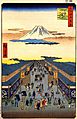
Mitsukoshi stores in Nihonbashi, by Hiroshige, c. 1836
-
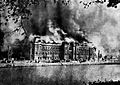
The Metropolitan Police headquarters on fire following the earthquake. The fire triggered by the earthquake caused fire whirls.
-
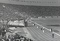
The 1964 Olympics in Tokyo symbolized the transition of the city from bombed-out ruins to a modern metropolis.
-
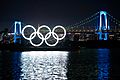
The 2020 Olympics were postponed and held in 2021 due to the COVID-19 pandemic.
-
The Great Kanto Earthquake in 1923 killed more than 100,000 citizens in Tokyo.
See also
 In Spanish: Tokio para niños
