Saitama Prefecture facts for kids
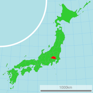
Saitama Prefecture (埼玉県, Saitama-ken) is a special area in Japan. It is located in the Kantō region on the big island of Honshū. Think of a prefecture like a state or province. The main city, or capital, of Saitama is Saitama City.
Contents
A Look Back in Time
Long ago, the area that is now Saitama Prefecture was part of a much older region called Musashi Province. Over time, Japan's regions changed, and Saitama became its own prefecture.
Where is Saitama?
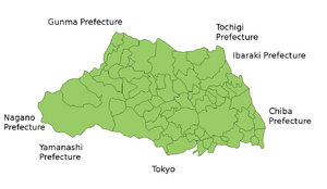
Saitama is in the Kantō region, which is a very important part of Japan. It shares its borders with several other prefectures. These include Chiba Prefecture, Ibaraki Prefecture, Gunma Prefecture, Nagano, Tochigi Prefecture, Yamanashi Prefecture, and the huge city of Tokyo.
Major Cities in Saitama
Saitama Prefecture has many interesting cities. Here are some of the biggest ones:
- Saitama City (the capital)
- Kawaguchi
- Shiki
- Kasukabe
- Soka
- Kumagaya
- Higashi-Matsuyama
- Gyoda
- Kuki
- Hasuda
- Okegawa
- Kounosu
- Ageo
- Toda
- Fujimi
- Kawagoe
Protecting Nature: National Parks
About one-third of Saitama Prefecture's land is set aside as national parks. These parks help protect nature and offer beautiful places for people to visit and enjoy the outdoors.
Important Shrines and Temples
One very important place in Saitama is the Hikawa Jinja. This is the main Shinto shrine for the prefecture. Shinto is a traditional Japanese religion, and shrines are places where people go to worship.
Friendship Across the World
Saitama Prefecture has special "friendship agreements" with different places around the world. These agreements help people from Saitama and these other places learn about each other's cultures and work together.
- Mexico State (since October 2, 1979)
- China Shanxi Province (since October 27, 1982)
- Australia Queensland (since October 27, 1984)
- Ohio, United States of America (since October 22, 1990)
- Brandenburg, Deutschland (since August 26, 1998)
More to Explore
If you want to learn more about Japan, check out these pages:
- Provinces of Japan
- Prefectures of Japan
- List of regions of Japan
- List of islands of Japan
- Urawa Red Diamonds
- Omiya Ardija
Images for kids
See also
 In Spanish: Prefectura de Saitama para niños
 | Lonnie Johnson |
 | Granville Woods |
 | Lewis Howard Latimer |
 | James West |


