
Ibaraki Prefecture facts for kids
Quick facts for kids Ibaraki Prefecture |
|||||||||
|
|||||||||
 |
|||||||||
| Capital | Mito | ||||||||
| Region | Kantō | ||||||||
| Island | Honshu | ||||||||
| Governor | Kazuhiko Ōigawa | ||||||||
| Area (rank) | 6,095.58 km² (23rd) | ||||||||
| - % water | 4.8% | ||||||||
| Population (September 1, 2010) | |||||||||
| - Population | 2,964,141 (11th) | ||||||||
| - Density | 486.28 /km² | ||||||||
| Districts | 7 | ||||||||
| Municipalities | 44 | ||||||||
| ISO 3166-2 | JP-08 | ||||||||
| Website | |||||||||
| Prefectural Symbols | |||||||||
| - Flower | Rose (Rosa) | ||||||||
| - Tree | Ume tree (Prunus mume) | ||||||||
| - Bird | Eurasian Skylark (Alauda arvensis) | ||||||||
| - Fish | |||||||||
 Symbol of Ibaraki Prefecture |
|||||||||

Ibaraki Prefecture (茨城県, Ibaraki-ken) is a special area in Japan. It's like a state or province. You can find it in the Kantō region on the big island of Honshu. The main city and capital of Ibaraki is Mito.
Contents
A Look Back in Time
Ibaraki Prefecture was created a long time ago, in 1871. Before that, it was known as Hitachi Province.
Where is Ibaraki?

Ibaraki Prefecture is in the northeastern part of the Kantō region. It sits between Tochigi Prefecture and the huge Pacific Ocean. To the north, it shares a border with Fukushima Prefecture. To the south, you'll find Chiba Prefecture. And to the southwest, it's next to Saitama Prefecture.
The northern part of Ibaraki has many mountains. But most of the prefecture is a flat plain with lots of lakes.
Bustling Cities
Ibaraki Prefecture has thirty-two cities. Here are some of them:
- Bandō
- Chikusei
- Hitachi
- Hitachinaka
- Hitachiōmiya
- Hitachiōta
- Hokota
- Inashiki
- Ishioka
- Itako
- Jōsō
- Kamisu
- Kasama
- Kashima
- Kasumigaura
- Kitaibaraki
- Koga
- Mito (This is the capital city!)
- Moriya
- Naka
- Namegata
- Omitama
- Ryūgasaki
- Sakuragawa
- Shimotsuma
- Takahagi
- Toride
- Tsuchiura
- Tsukuba
- Tsukubamirai
- Ushiku
- Yūki
Towns and Villages
Besides cities, Ibaraki also has many towns and villages. They are grouped into different districts:
- Higashiibaraki District
- Ibaraki
- Ōarai
- Shirosato
- Inashiki District
- Ami
- Kawachi
- Miho
- Kitasōma District
- Tone
- Kuji District
- Naka District
- Tōkai
- Sashima District
- Goka
- Sakai
- Yūki District
- Yachiyo
Nature's Beauty: National Parks
About 15% of Ibaraki Prefecture's land is set aside as national parks. These are special areas protected for their natural beauty.
Important Shrines and Temples
The main Shinto shrines in Ibaraki Prefecture are called Kashima jinja. Shinto shrines are places where people worship traditional Japanese gods and spirits.
Want to Learn More?
- Provinces of Japan
- Prefectures of Japan
- List of regions of Japan
- List of islands of Japan
- Kashima Antlers (a famous soccer team from Ibaraki!)
- Mito Hollyhock (another soccer team from Ibaraki!)
Images for kids
-
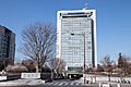
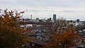
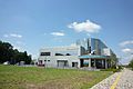
Ibaraki Prefectural Office and Headquarters in Mito
-
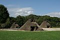
Kamitakatsu Shell Mound in Tsuchiura
-
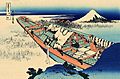
Lake Kasumigaura in Ushibori Village (Hitachi Province), Mount Fuji in the background; 19th century of the Edo period. Hokusai, painter and printmaker
-
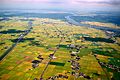
Rivers Shintone (left) and Tone ((right), Inashiki and Kawachi areas
-
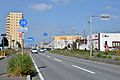
Tsuchiura
-
Ushiku
-
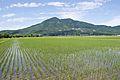
Paddy field at the foot of Mt. Tsukuba
-
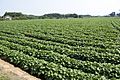
Sweet potato field in Namegata
-
Cyberdyne Inc. in Tsukuba
-
Kōdōkan (Mito)
-
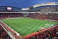
Kashima Soccer Stadium
-
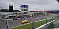
Tsukuba Circuit
-
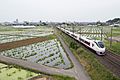
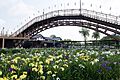
Lotus field and Jōban Line
-
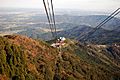
Mount Tsukuba Ropeway
-
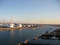
Kashima Port
-
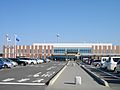
Ibaraki Airport
-
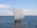
Hobikibune (Sailboat) on Lake Kasumigaura
-
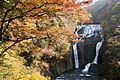
Fukuroda Falls in Daigo
-
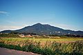
A view of Mount Tsukuba, from Tsukuba City
-
A view of Suigō Itako Iris Garden
-
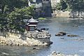
A view of Rokkakudō and Pacific Ocean in Kitaibaraki
-
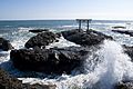
Torii of Ōarai Coast
-
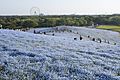
Nemophila in spring in Hitachi Seaside Park
-
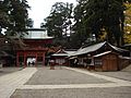
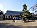
Kashima Shrine
-
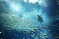
Ōarai Aquarium


.jpg)


_in_Hitachino-Higashi,Ushiku_city.jpg)


_2020.jpg)

_17.jpg)
.jpg)


See also
 In Spanish: Prefectura de Ibaraki para niños
