
Provinces of Japan facts for kids

The Provinces of Japan (令制国 (Ryōseikoku)) were like the main regions or states of Japan for a very long time, from the 600s until 1868.
These provinces were first set up in the late 600s. This happened under a set of laws called the Ritsuryō system. This system helped create Japan's first central government. Each province was then split into smaller areas called districts (郡, gun). These provinces were also grouped into larger geographic areas or "circuits" known as the Gokishichidō. This name means "Five Home Provinces and Seven Circuits."
The borders of these provinces changed a bit until the end of the Nara period (710 to 794). But after that, they stayed mostly the same from the Heian period (794 to 1185) all the way to the Edo period (1603 to 1868). During the later Muromachi period (1336 to 1573), the provinces shared power with another system called the han. These han were like personal lands owned by powerful feudal lords and warriors. Over time, the han became more important than the provinces.
The old provinces were replaced by the current prefecture system between 1868 and 1871. This change happened during the Meiji Restoration. The only exception was Hokkaido, which was divided into provinces from 1869 to 1882. No official rule ever said the provinces were completely gone. But they are not used for government work anymore. Still, people often talk about them, especially when giving directions or talking about products and places that use the old province names.
Contents
History of Japan's Provinces

The provinces were first created by the Ritsuryō reforms. They served as both government areas and geographic regions. However, starting from the late Muromachi period, powerful warlords called sengoku daimyō began to take over. Their own lands, called domains, slowly became more important than the provinces. During the time of Toyotomi Hideyoshi, these local daimyōs lands became the main local government units.
Edo Period Changes
In the Edo period, these lands of the daimyō were known as han. So, Japan had two main systems working together: the old imperial provinces and the new han domains. For example, if the shōgun (Japan's military ruler) wanted a census or maps made, the work was often organized using the old province borders.
Meiji Period Reforms
When the Meiji Restoration happened, the han were first made official government units. But soon, they were replaced by prefectures. This change happened between 1868 and 1871. At first, there were many prefectures, about 304 in 1871. The old provinces were 68. The borders of the new prefectures were very confusing and didn't match the old provinces.
Over time, many prefectures were combined. By 1881, there were only 37. A few were then divided, making 45 by 1885. Adding Hokkaidō and Okinawa made the current total of 47 prefectures.
The provinces were grouped into Kinai (areas near the capital, Kyoto) and seven or eight dō (routes or circuits). This system was called the Gokishichidō. It's important not to confuse these old "dō" with modern roads. Also, the old "Hokkaidō" circuit is not the same as the modern Hokkaidō Prefecture, even though they cover similar areas.
Provinces Today

Even though no one officially ended the provinces, they are not used for government anymore. However, their names are still very common! You can find them in names of mountains, rivers, company names, and even food brands. For example, you might hear of sanuki udon (noodles from Sanuki Province) or iyokan (a fruit from Iyo Province).
Train stations and cities sometimes use province names to avoid confusion. For instance, Musashi-Kosugi Station is different from other Kosugi stations. Simplified province names, like -shū, are also used, such as Shinshū soba (noodles from Shinano Province).
Sometimes, province names help describe different parts of today's prefectures. They show cultural or geographic features. For example, Hoku-Setsu (北摂) means the Northern (北) part of the old Settsu (摂津) area.
The old districts were once part of provinces. Now, they are part of prefectures. But because provinces were merged or divided, some districts might now be in different prefectures. Many of these old districts have disappeared as their main towns became part of bigger cities.
Here is a list of the provinces, grouped by the Gokishichidō (五畿七道) system. This list includes provinces that existed for only a short time. Provinces in Hokkaidō are listed last.
Goki (五畿, Five Provinces in Capital Region)

| Kinai | ||
| Tōkaidō | Tōsandō | Hokurikudō |
| San'indō | San'yōdō | Nankaidō |
| Saikaidō |
Provinces in the Capital Region (Kinai)
- Yamashiro (Jōshū, Sanshū, Yōshū) (山城国 (城州, 山州, 雍州))
- Yamato (Washū) (大和国 (和州))
- Kawachi (Kashū) (河内国 (河州))
- Izumi (Senshū) (和泉国 (泉州)) - Created in 716 from Kawachi Province. It was briefly part of Kawachi again in 740, but became separate again in 757.
- Settsu (Sesshū) (摂津国 (摂州))
Shichidō (七道, Seven Circuits)
East Sea Circuit (Tōkaidō)
- Iga (Ishū) (伊賀国 (伊州)) – separated from Ise Province in 680
- Ise (Seishū) (伊勢国 (勢州))
- Shima (Shishū) (志摩国 (志州)) – separated from Ise Province in the early 8th century
- Owari (Bishū) (尾張国 (尾州))
- Mikawa (Sanshū) (三河国 (三州))
- Tōtōmi (Enshū) (遠江国 (遠州))
- Suruga (Sunshū) (駿河国 (駿州))
- Izu (Zushū) (伊豆国 (豆州)) – separated from Suruga Province in 680
- Kai (Kōshū) (甲斐国 (甲州))
- Sagami (Sōshū) (相模国 (相州))
- Musashi (Bushū) (武蔵国 (武州)) – Moved from Tōsandō to Tōkaidō in 771
- Awa (Bōshū, Anshū) (安房国 (房州, 安州)) – Divided from Kazusa Province in 718. It re-joined Kazusa in 741, but separated again in 781.
- Kazusa (Sōshū) (上総国 (総州)) – divided from Fusa Province (総国) in the 7th century
- Shimōsa (Sōshū) (下総国 (総州)) – divided from Fusa Province in the 7th century
- Hitachi (Jōshū) (常陸国 (常州))
East Mountain Circuit (Tōsandō)
- Ōmi (Gōshū) (近江国 (江州))
- Mino (Nōshū) (美濃国 (濃州))
- Hida (Hishū) (飛騨国 (飛州))
- Shinano (Shinshū) (信濃国 (信州))
- Kōzuke (Jōshū) (上野国 (上州)) – divided from Keno Province (毛野国) during the 4th century
- Shimotsuke (Yashū) (下野国 (野州)) – divided from Keno Province during the 4th century
- Dewa (Ushū) (出羽国 (羽州)) – created from Dewa District in Echigo Province in 712. Later that year, Mogami and Okitama Districts from Mutsu Province joined Dewa.
- Mutsu (Ōshū, Rikushū) (陸奥国 (奥州, 陸州)) – split off from Hitachi Province in the 7th century
North Land Circuit (Hokurikudō)
- Wakasa (Jakushū) (若狭国 (若州))
- Echizen (Esshū) (越前国 (越州)) – broke off from Koshi Province (越国) in the late 7th century
- Kaga (Kashū) (加賀国 (加州)) – divided from Echizen Province in 823
- Noto (Nōshū) (能登国 (能州)) – divided from Echizen Province in 718. It was part of Etchu Province in 741, but separated again in 757.
- Etchū (Esshū) (越中国 (越州)) – broke off from Koshi Province in the late 7th century
- Echigo (Esshū) (越後国 (越州)) – broke off from Koshi Province in the late 7th century
- Sado (Sashū, Toshū) (佐渡国 (佐州, 渡州)) – was part of Echigo in 743, but separated again in 752
Mountain's Shady Side Circuit (San'indō)
- Tanba (Tanshū) (丹波国 (丹州))
- Tango (Tanshū) (丹後国 (丹州)) – divided from Tanba in 713
- Tajima (Tanshū) (但馬国 (但州))
- Inaba (Inshū) (因幡国 (因州))
- Hōki (Hakushū) (伯耆国 (伯州))
- Izumo (Unshū) (出雲国 (雲州))
- Iwami (Sekishū) (石見国 (石州))
- Oki (Onshū, Inshū) (隠岐国 (隠州))
Mountain's Sunny Side Circuit (San'yōdō)
- Harima (Banshū) (播磨国 (播州))
- Mimasaka (Sakushū) (美作国 (作州)) – divided from Bizen Province in 713
- Bizen (Bishū) (備前国 (備州)) – broke off from Kibi Province (吉備国) in the second half of the 7th century
- Bitchū (Bishū) (備中国 (備州)) – broke off from Kibi Province in the second half of the 7th century
- Bingo (Bishū) (備後国 (備州)) – broke off from Kibi Province in the second half of the 7th century
- Aki (Geishū) (安芸国 (芸州))
- Suō (Bōshū) (周防国 (防州))
- Nagato (Chōshū) (長門国 (長州))
South Sea Circuit (Nankaidō)
This circuit includes the island of Shikoku and a nearby area of Honshu.
- Kii (Kishū) (紀伊国 (紀州))
- Awaji (Tanshū) (淡路国 (淡州))
- Awa (Ashū) (阿波国 (阿州))
- Sanuki (Sanshū) (讃岐国 (讃州))
- Iyo (Yoshū) (伊予国 (予州))
- Tosa (Doshū) (土佐国 (土州))
West Sea Circuit (Saikaidō)
This circuit includes the island of Kyushu and its surroundings.
- Buzen (Hōshū) (豊前国 (豊州)) – broke off from Toyo Province (豊国) at the end of the 7th century
- Bungo (Hōshū) (豊後国 (豊州)) – broke off from Toyo Province at the end of the 7th century
- Chikuzen (Chikushū) (筑前国 (筑州)) – broke off from Tsukushi Province (筑紫国) by the end of the 7th century
- Chikugo (Chikushū) (筑後国 (筑州)) – broke off from Tsukushi Province by the end of the 7th century
- Hizen (Hishū) (肥前国 (肥州)) – broke off from Hi Province (火国) by the end of the 7th century
- Higo (Hishū) (肥後国 (肥州)) – broke off from Hi Province by the end of the 7th century
- Hyūga (Nisshū, Kōshū) (日向国 (日州, 向州)) – earlier called Kumaso Province (熊曾国)
- Ōsumi (Gūshū) (大隅国 (隅州)) – divided from Hyūga Province in 713
- Satsuma (Sasshū) (薩摩国 (薩州)) – divided from Hyūga Province in 702
- Iki (Isshū) (壱岐国 (壱州)) – officially Iki no Shima (壱岐嶋)
- Tsushima (Taishū) (対馬国 (対州)) – officially Tsushima no Shima (対馬嶋)
Hachidō (八道, Eight Circuits)
.svg)
North Sea Circuit (Hokkaidō)
This circuit covers the area of modern Hokkaido. It was first known as the Ezo Region. Later, it was renamed and organized into 11 provinces between 1869 and 1882.
- Oshima (渡島国)
- Shiribeshi (後志国)
- Iburi (胆振国)
- Ishikari (石狩国)
- Teshio (天塩国)
- Kitami (北見国)
- Hidaka (日高国)
- Tokachi (十勝国)
- Kushiro (釧路国)
- Nemuro (根室国)
- Chishima (千島国) - After the Treaty of Saint Petersburg (1875), Japan added islands north of Urup Island. These included Uruppu (得撫郡), Shimushiru (新知郡), and Shumushu (占守郡) Districts.
Gallery
-
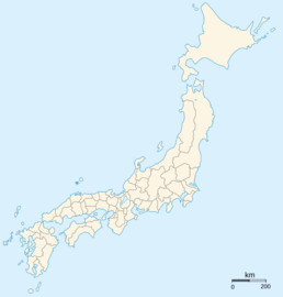
Borders of the provinces from the Kamakura period until 1868.
-

Map of Japan at the end of the Edo period published in the United States in 1855.
-
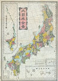
Meiji period map of Japan's provinces from around the 1880s, after they were replaced with the prefectures.


See also
 In Spanish: Provincias de Japón para niños
- Code of Taihō
- Magiri
- Kokushi (officials)
- Demographics of Japan before Meiji Restoration
- Ritsuryō
- Han (administrative division)
- Samurai
