Bingo Province facts for kids

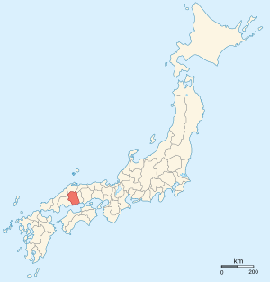
Bingo Province (called Bingo no kuni in Japanese) was an old area in Japan. It was located in what is now the eastern part of Hiroshima Prefecture, on the big island of Honshū. Sometimes, Bingo Province was grouped with Bizen and Bitchū Provinces. Together, they were sometimes called Bishū (備州).
Contents
Where Was Bingo Province?
Bingo Province shared its borders with several other old provinces. These included Bitchū, Hōki, Izumo, Iwami, and Aki Province. Its location was important for travel and trade in ancient Japan.
The Capital City
The main city, or capital, of Bingo Province was located in the area of what is now Fuchu. This was where the main government offices and important buildings for the province were found.
A Look at History

For many centuries, Japan was divided into these provinces. They were like states or regions with their own local governments. Over time, these areas changed.
From Provinces to Prefectures
During the Meiji period (which began in 1868), Japan went through many big changes. One of these changes was that the old provinces were replaced with a new system of prefectures. This happened in the 1870s. The maps of Japan were redrawn, and Bingo Province became part of the new Hiroshima Prefecture.
Important Places
Shrines and Temples
Kibitsu jinja was a very important place in Bingo Province. It was the chief Shinto shrine (called an ichinomiya) for the entire province. Shinto shrines are places of worship in Japan. An ichinomiya was considered the most important shrine in a province.
Related pages
See also
 In Spanish: Provincia de Bingo para niños
 | Kyle Baker |
 | Joseph Yoakum |
 | Laura Wheeler Waring |
 | Henry Ossawa Tanner |

