Owari Province facts for kids

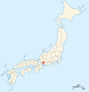
Owari Province (尾張国 (Owari no Kuni)) was an old part of Japan. It was located in the area that is now Aichi Prefecture on the island of Honshū. This included a big part of modern Nagoya. People also called it Bishū (尾州). The ancient capital city of Owari was close to Inazawa.
Contents
A Look Back: History of Owari

Owari Province was first created in the year 646.
During the Sengoku period, which was a time of many wars in Japan, a famous leader named Oda Nobunaga controlled Kiyosu Castle in Owari.
Later, in the Edo period, a very important road called the Tōkaidō road passed through Owari. This road was the main way to travel between the Imperial capital in Kyoto and the main city of the Tokugawa shogunate.
In the Meiji period, which started in the late 1800s, Japan changed its old provinces into new areas called prefectures. The maps of Japan and places like Owari Province were updated around the 1870s.
Where Was Owari Located?
Owari Province was separated from another province called Mino by the Sakai River.
Important Shrines and Temples
The most important Shinto shrine in Owari was called Masumida jinja. It was known as the ichinomiya, meaning the chief shrine of the province.
Related Places and Topics
See also
 In Spanish: Provincia de Owari para niños
 | Precious Adams |
 | Lauren Anderson |
 | Janet Collins |


