Tōkaidō (region) facts for kids
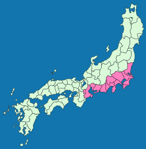
The Tōkaidō (東海道) is a Japanese name for an important part of ancient Japan. It was both a region of the country and a major road that went through it.
What is the Tōkaidō?
The Tōkaidō was part of an old system in Japan called the Gokishichidō. This system divided the country into different areas, like big circuits or districts. The Tōkaidō was one of the most important of these.
It was first set up a very long time ago, during the Asuka period in Japan. Over many hundreds of years, the way the government used these divisions changed. But the Tōkaidō, along with seven other regions, stayed important as cultural areas.
The old Tōkaidō road was made better and wider in the year 1604.
Provinces and Prefectures
The Tōkaidō region was made up of 15 old Japanese provinces. These were like states or large areas within the country. They included:
- Awa Province
- Hitachi Province
- Iga Province
- Ise Province
- Izu Province
- Kai Province
- Kazusa Province
- Mikawa Province
- Musashi Province
- Owari Province
- Sagami Province
- Shima Province
- Shimōsa Province
- Suruga Province
- Tōtōmi Province
Today, parts of five modern prefectures are in the area that was once the Tōkaidō region. These prefectures are Chiba, Ibaraki, Kanagawa, Saitama, and Tokyo.
The Tōkaidō Today
Today, a major national highway called Route 1 follows much of the path of the old Tōkaidō road. The only part that is different is the section between Tōkyō and Yokohama.
Another road, Route 15, follows the exact path of the old Tōkaidō between Tōkyō and Yokohama.
Related pages
See also
 In Spanish: Tōkaidō (región) para niños
 | Isaac Myers |
 | D. Hamilton Jackson |
 | A. Philip Randolph |


