
Okinawa Prefecture facts for kids
Quick facts for kids
Okinawa Prefecture
沖縄県
|
|||||||||||||||
|---|---|---|---|---|---|---|---|---|---|---|---|---|---|---|---|
| Japanese transcription(s) | |||||||||||||||
| • Japanese | 沖縄県 | ||||||||||||||
| • Rōmaji | Okinawa-ken | ||||||||||||||
|
Okinawa Peace Quasi-National Park
Cape Manzamo
Eisa Folks dance
Okinawa Soba noodle
Okinawa Churaumi Aquarium
A bullock cart in Taketomi Island
|
|||||||||||||||
|
|||||||||||||||
| Anthem: 沖縄県民の歌 (Okinawa kenmin no uta) | |||||||||||||||
 |
|||||||||||||||
| Country | |||||||||||||||
| Region | Kyushu | ||||||||||||||
| Island | Okinawa, Daitō, Miyako, Yaeyama, and Senkaku | ||||||||||||||
| Capital | Naha | ||||||||||||||
| Subdivisions | Districts: 5, Municipalities: 41 | ||||||||||||||
| Area | |||||||||||||||
| • Total | 2,281 km2 (881 sq mi) | ||||||||||||||
| Area rank | 44th | ||||||||||||||
| Population | |||||||||||||||
| • Total | 1,466,870 | ||||||||||||||
| • Rank | 29th | ||||||||||||||
| • Density | 643.08/km2 (1,665.6/sq mi) | ||||||||||||||
| GDP | |||||||||||||||
| • Total | JP¥ 4,633 billion US$ 42.5 billion (2019) |
||||||||||||||
| ISO 3166 code | JP-47 | ||||||||||||||
|
|||||||||||||||


Okinawa Prefecture (Japanese: 沖縄県, Hepburn: Okinawa-ken) is Japan's southernmost and westernmost prefecture. It has a population of about 1.4 million people. Its total area is 2,281 square kilometers.
Naha is the capital and largest city in Okinawa. Other important cities include Okinawa, Uruma, and Urasoe. Okinawa Prefecture includes two-thirds of the Ryukyu Islands. These islands stretch about 1,000 kilometers southwest from Kagoshima Prefecture towards Taiwan. The biggest island, Okinawa Island, is where most of Okinawa's people live. The native people of Okinawa are called the Ryukyuan people. They also live in the Amami Islands.
Okinawa was once its own kingdom, called the Ryukyu Kingdom, starting in 1429. Japan officially took control in 1879. After World War II, the United States occupied Okinawa. It was governed by the U.S. military until 1972, when it was returned to Japan. Okinawa is a small part of Japan's land, but it hosts a large number of United States Forces Japan personnel. This military presence is a topic of discussion among local people.
Contents
History of Okinawa

The first signs of humans on the Ryukyu Islands date back to the Stone Age. These were found in Naha and Yaeyama. Japanese influences from the Jōmon period are strong on the Okinawa Islands. However, clay pots on the Sakishima Islands are similar to those found in Taiwan.
The name Ryukyu first appeared in a Chinese book called the Book of Sui. The Japanese word Okinawa was first used in 779. Farming communities slowly grew from the 8th to the 12th century. Because the islands are located near Japan, China, and Southeast Asia, the Ryukyu Kingdom became a successful trading nation. During this time, many castles called Gusukus were built. In the 15th century, the Ryukyu Kingdom began trading with China's Ming dynasty.
In 1609, the Shimazu clan from what is now Kagoshima Prefecture invaded the Ryukyu Kingdom. The Ryukyu Kingdom had to agree to be under the control of the Shimazu clan and the Tokugawa shogunate. But it also kept its trading ties with China. This was important because Japan had strict rules about foreign trade. The Ryukyu Kingdom kept a lot of its freedom for over 200 years.
After the 1868 Meiji Restoration, the Japanese government officially took over the kingdom. It was renamed Ryukyu han. In 1879, Ryukyu han became Okinawa Prefecture of Japan. In 1912, Okinawans were first allowed to vote for representatives in Japan's parliament, the National Diet (国会).
Okinawa After World War II (1945–1972)
On April 1, 1945, the U.S. Army and Marine Corps invaded Okinawa. About one-third of Okinawa's civilians died during the fighting. All those who died are remembered at the Cornerstone of Peace.
After World War II, the United States governed Okinawa for 27 years. During this time, the U.S. built many military bases on the Ryukyu islands. Some Okinawans wanted independence from U.S. rule.
During the Korean War, U.S. planes flew bombing missions from Kadena Air Base on Okinawa. The military presence grew during the Cold War. This created some tension between local people and the American military. Under a 1952 agreement, United States Forces Japan (USFJ) kept a large military presence.
In the mid-1950s, the U.S. took land from Okinawans to build or expand bases. By 1955, about 250,000 residents had to move from their homes.
Return to Japan and Modern Issues (1972–Present)
On May 15, 1972, the U.S. government returned the islands to Japanese control. Even though Okinawa is less than 1% of Japan's land, it still hosts about 75% of all U.S. military bases in Japan. These bases take up about 18% of the main island.
A 2007 poll showed that 85% of Okinawans were against the U.S. military presence. They were concerned about noise from drills, aircraft accidents, and environmental issues. However, 73% of Japanese citizens liked the security agreement with the U.S. A 2010 poll found that 43% of Okinawans wanted the U.S. bases to close completely. Another 42% wanted them reduced. Some Okinawans feel that the government in Tokyo does not understand their needs.
In 2009, a new Japanese government paused the plan to move U.S. forces. But in 2010, they suggested a new plan. A study in 2010 found that constant aircraft noise around Kadena Air Base caused health problems for people. These included disrupted sleep and high blood pressure.
In 2018, Denny Tamaki was elected governor of Okinawa. His campaign focused on reducing the U.S. military presence on the island.
Relocation of Marine Corps Air Station Futenma
In 2006, about 8,000 U.S. Marines moved from Okinawa to Guam. Japan helped pay for building the new base there. The U.S. still has Air Force, Marine, Navy, and Army bases on the islands. These include Kadena Air Base and Camp Foster.
Suburbs have grown around two major bases, Futenma and Kadena. A large part of the land used by the U.S. military is Camp Gonsalves in the north. In 2016, 10,000 acres of Camp Gonsalves were given back to Japan. In 2018, Okinawa residents protested against new construction for a U.S. military base.
Since the early 2000s, Okinawans have opposed new helicopter pads in the Yanbaru forest. This opposition grew in 2016 after six new helipads were built.
Geography of Okinawa

Okinawa Prefecture is made up of the southern two-thirds of the Ryūkyū Islands. Okinawa's inhabited islands are grouped into three main areas. From northeast to southwest, they are:
- Okinawa Islands (including Okinawa Island and Kerama Islands)
- Miyako Islands (including Miyako-jima)
- Yaeyama Islands (including Iriomote Island and Ishigaki Island)
Other important islands include the Senkaku Islands and Daitō Islands.
Natural Parks
About 36% of Okinawa's land is protected as natural parks. These include Iriomote-Ishigaki National Park, Kerama Shotō National Park, and Yambaru National Park. There are also several Quasi-National Parks and Prefectural Natural Parks.
Ecology and Wildlife
Okinawa is home to unique animals. The dugong, a marine mammal similar to a manatee, is endangered here. Iriomote Island has the Iriomote cat, one of the rarest cats in the world. The islands also have a special type of pit viper snake called Trimeresurus elegans.
The waters around Okinawa have many beautiful coral reefs. The world's largest group of rare blue coral is found near Ishigaki Island. Sea turtles come to the southern islands each year to lay their eggs. During summer, swimmers are warned about venomous jellyfish and other dangerous sea creatures.
Okinawa grows a lot of sugar cane, pineapple, and papaya. The Southeast Botanical Gardens show off many tropical plants.
Geology and Caves
Okinawa Island is mostly made of coral. Rainwater filtering through the coral has created many caves. These caves were important during the Battle of Okinawa. Gyokusendo is a large limestone cave in the southern part of Okinawa's main island.
Climate
Okinawa has warm weather for most of the year, with temperatures usually above 20°C. The climate ranges from humid subtropical climate in the north (like Okinawa Island) to tropical rainforest climate in the south (like Iriomote Island). Snowfall is very rare at sea level. However, sleet was reported in Nago for the first time ever in January 2016.
Cities and Towns

Okinawa Prefecture has eleven cities:
| Name | Area (km2) | Population | Map | ||||
|---|---|---|---|---|---|---|---|
| Rōmaji | Kanji | Okinawan | other languages [script]
(name in brackets) |
||||
| Kana | Rōmaji | ||||||
| 宜野湾市 | じのーん | Jinōn | 19.51 | 94,405 | |||
| 石垣市 | いしがち | ʔIshigaci | Isïgaksï, Ishanagzï (Yaeyama) | 229 | 47,562 | ||
| 糸満市 | いちゅまん | ʔIcuman | 46.63 | 59,605 | |||
| 宮古島市 | なーく、みゃーく | Nāku, Myāku | Myaaku (Miyakoan) | 204.54 | 54,908 | ||
| 名護市 | なぐ | Nagu | Naguu [ナグー] (Kunigami) | 210.37 | 61,659 | ||
| 那覇市 | な |
Nafa | 39.98 | 317,405 | |||
| 南城市 | Fēgusiku | 49.69 | 41,305 | ||||
| 沖縄市 | うちなー | ʔUcinā | 49 | 138,431 | |||
| 豊見城市 | Timigusiku | 19.6 | 61,613 | ||||
| 浦添市 | うら |
ʔUrasī | 19.09 | 113,992 | |||
| うるま市 | うるま | ʔUruma | 86 | 118,330 | |||
Towns and Villages
Here are the towns and villages in each district:
| Name | Area (km2) | Population | District | Type | Map | ||||
|---|---|---|---|---|---|---|---|---|---|
| Rōmaji | Kanji | Okinawan | other languages [script]
(name in brackets) |
||||||
| Kana | Rōmaji | ||||||||
| 粟国村 | あぐに | ʔAguni | 7.63 | 772 | Shimajiri District | Village | |||
| 北谷町 | ちゃたん | Catan | 13.62 | 28,578 | Nakagami District | Town | |||
| 宜野座村 | じぬざ | Jinuza | 31.28 | 5,544 | Kunigami District | Village | |||
| 南風原町 | Fēbaru | 10.72 | 37,874 | Shimajiri District | Town | ||||
| 東村 | Figashi | Agaarijimaa [アガーリジマー]
(Kunigami) |
81.79 | 1,683 | Kunigami District | Village | |||
| 伊江村 | いい | ʔIi | Ii [イー] (Kunigami) | 22.75 | 4,192 | Kunigami District | Village | ||
| 伊平屋村 | いひゃ、後地 | ʔIhya, Kushijī | 21.72 | 1,214 | Shimajiri District | Village | |||
| 伊是名村 | いじな、前地 | ʔIjina, Mējī | 15.42 | 1,518 | Shimajiri District | Village | |||
| 嘉手納町 | か |
Kadinā | 15.04 | 13,671 | Nakagami District | Town | |||
| 金武町 | ちん | Cin | Chin [チン] (Kunigami) | 37.57 | 11,259 | Kunigami District | Town | ||
| 北大東村 | うふあがりじま | ʔUhuʔagarijima | 13.1 | 615 | Shimajiri District | Village | |||
| 北中城村 | にしなかーぐ |
Nishinakāgusiku | 11.53 | 16,040 | Nakagami District | Village | |||
| 久米島町 | くみじま | Kumijima | 63.5 | 7,647 | Shimajiri District | Town | |||
| 国頭村 | くんじゃん | Kunjan | Kunzan (Kunigami) | 194.8 | 4,908 | Kunigami District | Village | ||
| 南大東村 | Hwēʔuhuʔagarijima | 30.57 | 1,418 | Shimajiri District | Village | ||||
| 本部町 | む |
Mutubu | Mutubu (Kunigami) | 54.3 | 13,441 | Kunigami District | Town | ||
| 中城村 | なかーぐ |
Nakāgusiku | 15.46 | 20,030 | Nakagami District | Village | |||
| 今帰仁村 | なちじん | Nacijin | Nachizin (Kunigami) | 39.87 | 9,529 | Kunigami District | Village | ||
| 西原町 | にしばる | Nishibaru | 15.84 | 34,463 | Nakagami District | Town | |||
| 大宜味村 | Ujimi | Uujimii (Kunigami) | 63.12 | 3,024 | Kunigami District | Village | |||
| 恩納村 | うんな | ʔUnna | Unna (Kunigami) | 50.77 | 10,443 | Kunigami District | Village | ||
| 多良間村 | たらま | Tarama | Tarama (Miyakoan) | 21.91 | 1,194 | Miyako District | Village | ||
| 竹富町 | だき |
Dakidun | Teedun (Yaeyama) | 334.02 | 4,050 | Yaeyama District | Town | ||
| 渡嘉敷村 | Tukashici | 19.18 | 697 | Shimajiri District | Village | ||||
| 渡名喜村 | Tunaci | 3.74 | 406 | Shimajiri District | Village | ||||
| 八重瀬町 | え゙ー |
Ēsi | 26.9 | 29,488 | Shimajiri District | Town | |||
| 読谷村 | Yuntan | 35.17 | 40,517 | Nakagami District | Village | ||||
| 与那原町 | Yunabaru | 5.18 | 18,410 | Shimajiri District | Town | ||||
| 与那国町 | Yunaguni | Dunan, Juni (Yonaguni)
Yunoon (Yaeyama) |
28.95 | 2,048 | Yaeyama District | Town | |||
| 座間味村 | ざまみ | Zamami | 16.74 | 924 | Shimajiri District | Village | |||
People of Okinawa

Ethnic Groups
The native Ryukyuan people make up most of Okinawa's population. They are also the main ethnic group in the Amami Islands. Many Okinawans have moved to places like South America and Hawaii. With U.S. military bases, there are more children of mixed American and Okinawan heritage. The current governor, Denny Tamaki, is one example.
There are also many Yamato people from mainland Japan living in Okinawa. It's hard to know exact numbers because the Japanese government doesn't officially see Ryukyuans as a separate ethnic group.
A survey found that 40.6% of Okinawans identify as "Okinawan." About 21.3% identify as "Japanese." And 36.5% identify as both.
Population Growth
Okinawa Prefecture has seen its population grow steadily since 1960.
| Historical population | ||
|---|---|---|
| Year | Pop. | ±% |
| 1873 | 166,789 | — |
| 1920 | 572,000 | +242.9% |
| 1930 | 578,000 | +1.0% |
| 1940 | 575,000 | −0.5% |
| 1950 | 915,000 | +59.1% |
| 1960 | 883,000 | −3.5% |
| 1970 | 945,000 | +7.0% |
| 1980 | 1,107,000 | +17.1% |
| 1990 | 1,222,000 | +10.4% |
| 2000 | 1,318,220 | +7.9% |
| 2010 | 1,392,818 | +5.7% |
| 2020 | 1,457,162 | +4.6% |
Language and Culture


Okinawan language and culture are different from mainland Japan. This is because Okinawa was a separate nation until 1879.
Language
There are six Ryukyuan languages still spoken. These languages are related to Japanese but are not easily understood by Japanese speakers. One of these languages is spoken in Kagoshima Prefecture. These languages are becoming less common as younger Okinawans use Standard Japanese.
Mainland Japanese people often think of Ryukyuan languages as "dialects." In formal situations, Standard Japanese is almost always used. In daily life, Okinawans under 60 often speak a Japanese with an Okinawan accent. The traditional Okinawan language is still used in cultural activities like folk music and folk dance. There is even a radio news program in the language.
Religion
Okinawans traditionally follow Ryukyuan religious beliefs. These beliefs often involve ancestor worship. They also respect the connections between living people, the dead, and the spirits of nature.
Culture
Okinawan culture shows influences from its past trading partners. You can see Chinese, Thai, and Austronesian influences in its customs.
Perhaps Okinawa's most famous cultural export is karate. It likely came from the close ties with China. Karate is thought to be a mix of Chinese kung fu and traditional Okinawan martial arts.
A traditional Okinawan product is awamori. This is an Okinawan spirit made from rice imported from Thailand.
Another important part of Okinawan culture is the sanshin. This is a three-stringed Okinawan instrument, similar to a banjo. Its body is often covered with snakeskin. The eisa dance is a traditional drumming dance. A traditional fabric called bingata is also made here.
The Okinawan diet is known for being low in fat and salt. It includes many fruits, vegetables, beans, tofu, and seaweed. Okinawans are especially known for eating purple sweet potatoes. In the past, Okinawans were famous for living longer than people in other parts of the world. This area was called a Blue Zone. Their diet, low-stress lifestyle, and strong community might have helped. However, in recent years, Okinawans' life expectancy has decreased. Some people blame this on influences from mainland Japan and other countries.
Okinawans also form moais. A moai is a community group that offers financial and emotional support. These groups help people feel secure and connected.
Several Okinawan writers have won the Akutagawa Prize. These include Eiki Matayoshi, Shun Medoruma, Tatsuhiro Oshiro, and Mineo Higashi.
Karate

Karate started in Okinawa. Over time, it developed into many different styles. In Okinawa, the three main styles are Shōrin-ryū, Gōjū-ryū, and Uechi-ryū. Karate is now popular worldwide and was even included in the 2020 Summer Olympics.
Architecture


Even though many buildings were destroyed during World War II, there are still remains of unique castles called gusuku. The most important ones are on the UNESCO World Heritage List. Shuri Castle in Naha is one of these UNESCO World Heritage Sites.
Most homes in Japan are made of wood to help with humidity. But modern Okinawan homes are often made of concrete. They have barred windows to protect against flying debris and strong typhoons. Roofs are built to withstand strong winds, with each tile cemented in place. Many roofs also have a lion-dog statue called a shisa. These are believed to protect the home from danger. Okinawan roofs are often red and show Chinese design influences.
Education in Okinawa
The public schools in Okinawa are managed by the Okinawa Prefectural Board of Education. They run several public high schools, including Okinawa Shogaku High School. The U.S. Department of Defense Dependents Schools operates 13 schools in Okinawa, with seven on Kadena Air Base.
Okinawa has many private schools. Some are cram schools, also known as juku. Others, like Nova, teach only languages. There are 10 colleges and universities in Okinawa. These include the University of the Ryukyus, which is the only national university in the prefecture. The Okinawa Institute of Science and Technology is a new international research institute. U.S. military bases in Okinawa also host the Asian Division of the University of Maryland University College.
Sports in Okinawa
Martial Arts
Martial arts like tegumi and Okinawan kobudō began with the native people of Okinawa Island. Because of its location, Okinawa's martial arts were influenced by cultures from Japan, China, and Southeast Asia.
Karate
Karate started in the Ryukyu Kingdom, with Chinese influences. After Okinawa was occupied, Karate spread to the United States and then worldwide. It is now very popular.
Team Sports
- Association Football: FC Ryukyu is a professional football team from Okinawa. They play in Japan's national league system.
- Basketball:

The Ryukyu Golden Kings are a professional basketball team. They play in the B.League, Japan's top professional basketball league. They have won the national title five times, most recently in 2023. The Okinawa Arena has hosted games for the Japan men's national basketball team. It was also one of the venues for the 2023 FIBA Basketball World Cup.
- Handball: Ryukyu Corazon is a handball team based in Naha.
- Baseball: The Ryukyu Blue Oceans are expected to be Okinawa's first professional baseball team. Many Japanese baseball teams train in Okinawa during the winter. This is because Okinawa is the warmest prefecture in Japan and has no snow. Teams like SoftBank Hawks and Yokohama BayStars train here.
Golf
Okinawa has many golf courses. There used to be a professional golf tournament called the Okinawa Open.
Transportation
Air Transportation
Okinawa has several airports, connecting its islands and linking to mainland Japan. Some of these include:
- Aguni Airport
- New Ishigaki Airport
- Kumejima Airport
- Miyako Airport
- Naha Airport
- Yonaguni Airport
Highways
Major highways in Okinawa include:
- Okinawa Expressway
 National Route 58
- National Route 329
- National Route 330
- National Route 331
Rail
- Okinawa Urban Monorail is a train system in Naha.
Ports
The main ports in Okinawa are:
- Naha Port
- Port of Unten
- Port of Kinwan
- Nakagusukuwan Port
- Hirara Port
- Port of Ishigaki
Economy
The 34 U.S. military bases in Okinawa receive financial support from both the U.S. and Japan. These bases provide jobs for Okinawans. In 2011, the U.S. military employed over 9,800 Japanese workers in Okinawa. As of 2012, the bases contributed up to 5% of the local economy. The Japanese government also pays the Okinawa government about ¥10 billion each year. This money is partly to make up for the American military presence. It also includes rent paid to Okinawans whose land is used for the bases.
In 2015, after Governor Takeshi Onaga was elected, the national government announced that Okinawa's funding would be cut. This was because the governor wanted the U.S. military bases removed from Okinawa, which the national government did not support.
The Okinawa Convention and Visitors Bureau is looking into using military base facilities for large events.
United States Military Installations
- United States Marine Corps
- Marine Corps Base Camp Smedley D. Butler
- Camp Foster
- Marine Corps Air Station Futenma
- Camp Kinser
- Camp Courtney
- Camp McTureous
- Camp Hansen
- Camp Schwab
- Camp Gonsalves (Jungle Warfare Training Center)
- Marine Corps Base Camp Smedley D. Butler
- United States Air Force
- Kadena Air Base
- Okuma Beach Resort
- United States Navy
- Camp Lester (Camp Kuwae)
- Camp Shields
- Naval Facility White Beach
- United States Army
- Torii Station
- Fort Buckner
- Naha Military Port
Notable People from Okinawa
- Namie Amuro, hip hop and pop singer
- Yui Aragaki, actress, singer and model
- Awich, rapper, singer and songwriter
- Beni, pop and R&B singer
- Zach Bryan, country musician and singer-songwriter
- Michael Carter, National Football League player
- Isamu Chō, officer in the Imperial Japanese Army
- Merle Dandridge, American actress and singer
- Byron Fija, Okinawan language practitioner and activist
- Gichin Funakoshi, martial artist, founder of Shotokan
- Gigō Funakoshi, martial artist
- Gackt, pop rock singer-songwriter, actor and author
- Robert Griffin III, National Football League player, Heisman Trophy winner
- Hearts Grow, alternative rock band
- Takuji Iwasaki, meteorologist, biologist and ethnologist historian
- Eiki Matayoshi, novel writer, winner of Akutagawa prize
- Jin Matsuda, singer, member of INI
- Saori Minami, kayōkyoku pop singer
- Daichi Miura, pop singer, dancer and choreographer
- Chōjun Miyagi, martial artist, founder of Gōjū-ryū
- Yukie Nakama, singer, musician and actress
- Rino Nakasone, professional dancer and choreographer
- Rimi Natsukawa, pop singer
- Orange Range, rock band
- Minoru Ōta, admiral in the Imperial Japanese Navy
- Dave Roberts, Major League Baseball player and manager
- Toshiyuki Sakuda, professional wrestler
- Eisaku Satō, politician, 61st, 62nd and 63rd Prime Minister of Japan
- Aisa Senda, singer, actress and TV presenter in Taiwan
- Ben Shepherd, bassist of Soundgarden
- Stereopony, all-female pop rock band
- Noriyuki Sugasawa, basketball player
- Super Shisa, professional wrestler
- Tina Tamashiro, fashion model and actress
- Yuken Teruya, interdisciplinary artist
- Tamlyn Tomita, actress and singer
- Kanbun Uechi, martial artist, founder of Uechi-ryū
- Mitsuru Ushijima, general at the Battle of Okinawa
- Kentsū Yabu, martial artist prominent in Shōrin-ryū
- Chikako Yamashiro, filmmaker and video artist
- Sho Yonashiro, singer, member of JO1
Images for kids
-

Tourists on traditional buffalo carts arrive at Yubu Island in Taketomi Town.
-
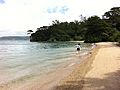
Nago, Okinawa Prefecture, Japan.
-

Map of US Military Bases in Okinawa in 1969.
-

U.S. military facilities in Okinawa.
-
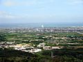
Ishigaki city center.
-
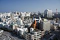
Naha city.


See also
 In Spanish: Prefectura de Okinawa para niños
