
Ishigaki, Okinawa facts for kids
Quick facts for kids
Ishigaki
石垣市
Isïgaksï, Ishanagzï |
|||
|---|---|---|---|

Top left: Mount Omoto, Top right: Mount Nosoko, 2nd row: Kabira Bay from Kabira Park, lower left: 730 Street in downtown Ishigaki, lower right: Shiraho natural reef, Bottom of left: Hirakubo peninsula from Tamatorizaki, Bottom right: Miyara old residence site
|
|||
|
|||

Location of Ishigaki in Okinawa Prefecture
|
|||

Ishigaki
Location in Japan
|
|||
| Country | Japan | ||
| Region | Kyushu | ||
| Prefecture | Okinawa Prefecture | ||
| Area | |||
| • Total | 229.00 km2 (88.42 sq mi) | ||
| Population
(October 1, 2016)
|
|||
| • Total | 47,562 | ||
| • Density | 213/km2 (550/sq mi) | ||
| Time zone | UTC+9 (Japan Standard Time) | ||
| - Tree | Yaeyama kokutan (Diospyros ferrea) | ||
| - Flower | Sakishima tsutsuji (Rhododendron amanoi, Ohwi) | ||
| - Bird | Crested serpent eagle | ||
| - Butterfly | Rice paper butterfly | ||
| - Fish | Hamafuefuki (Lethrinus nebulosus) | ||
| - Shell | Black-lip oyster (Pinctada margaritifera) | ||
| Phone number | 0980-82-9911 | ||
| Address | 14 Misakichō, Ishigaki-shi 907-8501 | ||
| Climate | Af | ||


Ishigaki (石垣市, Ishigaki-shi, Yaeyama: Isïgaksï, Ishanagzï) is a lively city in Okinawa Prefecture, Japan. It's located on Ishigaki Island and also includes the Senkaku Islands. Ishigaki is a very important place for the Yaeyama Islands. It's the main center for government, culture, and business.
The city is served by New Ishigaki Airport. As of 2012, about 48,816 people lived there. The city covers an area of 229 square kilometers.
Contents
History of Ishigaki
The city of Ishigaki started in 1908. It was first called Yaeyama Village. This village was a mix of three smaller areas: Ishigaki, Ōhama, and Miyara.
In 1914, its name changed to Ishigaki Village. It grew larger and became Ishigaki Town in 1926. Finally, on July 10, 1947, Ishigaki officially became a city.
An interesting fact: One of the first French visitors to Japan, Guillaume Courtet, landed in Ishigaki in 1636.
Geography of Ishigaki
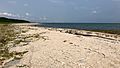
The city of Ishigaki covers all of Ishigaki Island. This island is about 222 square kilometers in size. Beautiful coral reefs surround the island.
The highest point on Ishigaki Island is a mountain called Omotodake. It stands tall at 525.5 meters.
The Senkaku Islands are also part of Ishigaki. These islands are not lived on by people. They are located about 150 kilometers north of Ishigaki Island. The Senkaku Islands cover an area of roughly 6.3 square kilometers.
Ishigaki's Neighborhoods
The city of Ishigaki is divided into twenty-four smaller areas called wards.
- Arakawa (新川)
- Fukai (桴海)
- Hamasakichō (浜崎町)
- Hirae (平得)
- Hirakubo (平久保)
- Ibaruma (伊原間)
- Ishigaki (石垣)
- Kabira (川平)
- Maezato (真栄里)
- Misakichō (美崎町)
- Miyara (宮良)
- Moriyama (盛山)
- Nagura (名蔵)
- Nosoko (野底)
- Ōhama (大浜)
- Ōkawa (大川)
- Painuhamachō (南ぬ浜町)
- Sakieda (崎枝)
- Shin'eichō (新栄町)
- Shiraho (白保)
- Tonoshiro (登野城)
- Tonoshirosenkaku (登野城尖閣)
- Tōzato (桃里)
- Yashimachō (八島町)
Economy and Jobs
Ishigaki is known for growing sugarcane and pineapples. These crops are an important part of the local economy.
Tourism is also a very big industry in Ishigaki. Many people visit the city to enjoy its natural beauty and sights.
Getting Around Ishigaki
The city has its own airport, New Ishigaki Airport. This airport connects Ishigaki to other parts of Japan.
There is also Ishigaki Port. This port is important for travel by sea and for shipping goods.
Climate in Ishigaki
Ishigaki has a tropical rainforest climate. This means it's warm all year round. Summers are hot and winters are warm.
The city gets a lot of rain throughout the year. August and September are the rainiest months. This is often because of tropical storms or typhoons. December and July are usually the driest months.
| Climate data for Ishigaki (1991−2020 normals, extremes 1896−present) | |||||||||||||
|---|---|---|---|---|---|---|---|---|---|---|---|---|---|
| Month | Jan | Feb | Mar | Apr | May | Jun | Jul | Aug | Sep | Oct | Nov | Dec | Year |
| Record high °C (°F) | 27.8 (82.0) |
29.1 (84.4) |
29.4 (84.9) |
32.9 (91.2) |
33.7 (92.7) |
34.6 (94.3) |
35.3 (95.5) |
35.6 (96.1) |
35.4 (95.7) |
33.2 (91.8) |
30.9 (87.6) |
29.0 (84.2) |
35.6 (96.1) |
| Mean daily maximum °C (°F) | 21.5 (70.7) |
22.0 (71.6) |
23.7 (74.7) |
26.0 (78.8) |
28.7 (83.7) |
30.9 (87.6) |
32.2 (90.0) |
32.0 (89.6) |
31.0 (87.8) |
28.8 (83.8) |
26.2 (79.2) |
23.0 (73.4) |
27.2 (81.0) |
| Daily mean °C (°F) | 18.9 (66.0) |
19.4 (66.9) |
20.9 (69.6) |
23.4 (74.1) |
25.9 (78.6) |
28.4 (83.1) |
29.6 (85.3) |
29.4 (84.9) |
28.2 (82.8) |
26.0 (78.8) |
23.6 (74.5) |
20.5 (68.9) |
24.5 (76.1) |
| Mean daily minimum °C (°F) | 16.7 (62.1) |
17.2 (63.0) |
18.6 (65.5) |
21.3 (70.3) |
23.9 (75.0) |
26.6 (79.9) |
27.7 (81.9) |
27.3 (81.1) |
26.0 (78.8) |
23.9 (75.0) |
21.5 (70.7) |
18.4 (65.1) |
22.4 (72.3) |
| Record low °C (°F) | 6.0 (42.8) |
5.9 (42.6) |
7.2 (45.0) |
10.0 (50.0) |
11.2 (52.2) |
16.5 (61.7) |
20.0 (68.0) |
17.4 (63.3) |
17.2 (63.0) |
14.0 (57.2) |
7.1 (44.8) |
6.6 (43.9) |
5.9 (42.6) |
| Average precipitation mm (inches) | 135.0 (5.31) |
124.0 (4.88) |
134.4 (5.29) |
146.9 (5.78) |
190.7 (7.51) |
208.2 (8.20) |
142.3 (5.60) |
249.8 (9.83) |
259.7 (10.22) |
211.2 (8.31) |
138.1 (5.44) |
155.2 (6.11) |
2,095.5 (82.50) |
| Average precipitation days (≥ 0.5 mm) | 14.9 | 11.7 | 11.7 | 10.3 | 11.1 | 10.0 | 10.4 | 13.3 | 13.1 | 12.3 | 12.8 | 14.8 | 146.3 |
| Average relative humidity (%) | 72 | 73 | 74 | 77 | 79 | 81 | 77 | 78 | 76 | 73 | 73 | 71 | 75 |
| Mean monthly sunshine hours | 84.7 | 91.3 | 118.1 | 130.3 | 164.3 | 212.9 | 261.0 | 232.9 | 189.9 | 157.6 | 115.3 | 89.3 | 1,852.5 |
| Source: Japan Meteorological Agency | |||||||||||||
Places to Visit in Ishigaki
Ishigaki has many interesting places to see:
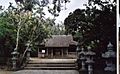
- Gongen Do is a Shinto shrine. It was built in 1614 but was destroyed by a flood in 1771. The buildings you see today were built in 1787.
- Next to Gongen Do is Torin Ji. This is a Buddhist temple, also founded in 1614. It has old statues from 1737.
- Miyaradunchi is a special house from 1819. It looks like a samurai house from mainland Japan, even though there were no samurai on the Yaeyama Islands.
- The Museum of the Yaeyama Islands (Shiritsu Yaeyama Hakubutsukan) is on Main Street. It shows boats and other items about the history and culture of the Yaeyama Islands. It's famous for being Japan's southernmost museum!
- Fuzaki Kannon Do is a small Shinto shrine from 1742. It's about 5 kilometers west of town on a hill. From there, you can see amazing views of Ishigaki and the nearby island, Iriomote. This shrine is dedicated to Kannon, a Buddhist goddess.
- Tojinbaka is a unique tomb in a Chinese style. It's about 6 kilometers west of town. This tomb is where 400 Chinese workers are buried. They died in 1852 during a rebellion on a ship heading to America.
- Kabira Bay is a beautiful bay known for its clear blue waters and green islands. It's a popular spot for tourists.
Notable People from Ishigaki
Many talented people come from Ishigaki:
- Yudai Arashiro (born 1995) – a professional cyclist.
- Yukiya Arashiro (born 1984) – also a professional cyclist.
- Begin (band) (all members born 1968) – a popular Japanese pop music group.
- Yōkō Gushiken (born 1955) – a famous boxer.
- Rimi Natsukawa (born 1973) – a well-known folk singer.
- Kaima Taira (born 1999) – a professional baseball pitcher.
Sister Cities
Ishigaki has special friendships with other cities, called "sister cities."
In Japan
- Kamiita, Tokushima
- Kitakami, Iwate
- Okazaki, Aichi
- Wakkanai, Hokkaido
Overseas
- Kauai County, Hawaii, United States
- Su'ao, Taiwan
Images for kids
-
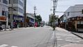
Shinyakusho-Dori
-
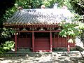
Shinto shrine Gongen Do
-
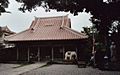
Torin Ji Temple
-
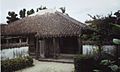
Miyara Donchi
-
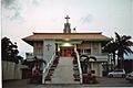
Catholic Church in Ishigaki
-
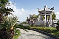
Shrine Fuzaki Kannon Do
-
Tojinbaka Tomb
-
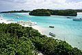
Kabira Bay
-
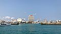
Ishigaki Port
-
Ishigaki viewed from Taketomi


.jpg)

See also
 In Spanish: Ishigaki (Okinawa) para niños
