Kauai County, Hawaii facts for kids
Quick facts for kids
Kauai County
|
||
|---|---|---|

|
||
|
||

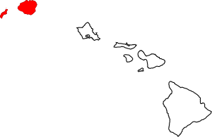
Location within the U.S. state of Hawaii
|
||
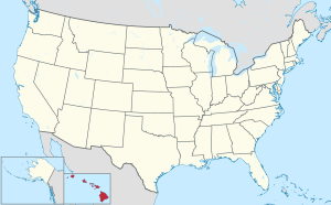
 Hawaii's location within the U.S. |
||
| Country | ||
| State | ||
| Founded | 1905 | |
| Seat | Lihue | |
| Largest community | Kapa‘a | |
| Area | ||
| • Total | 1,266 sq mi (3,280 km2) | |
| • Land | 620 sq mi (1,600 km2) | |
| • Water | 646 sq mi (1,670 km2) 51.0%% | |
| Population
(2020)
|
||
| • Total | 73,298 | |
| • Density | 57.897/sq mi (22.354/km2) | |
| Time zone | UTC−10 (Hawaii–Aleutian) | |
| • Summer (DST) | HADT | |
| Congressional district | 2nd | |
Kauaʻi County, officially known as the County of Kauaʻi, is a special area in the U.S. state of Hawaiʻi. It includes the islands of Kauaʻi, Niʻihau, Lehua, and Kaʻula. In 2020, about 73,298 people lived here. The main town and government center is Līhuʻe.
Contents
Exploring Kauaʻi County's Location
Kauaʻi County covers a total area of about 1,266 square miles (3,279 km²). More than half of this area (51%) is water, mostly the Pacific Ocean. The land area is about 620 square miles (1,606 km²).
Nearby Areas
Kauaʻi County is surrounded by the Pacific Ocean. Its closest neighbors are:
- Honolulu County, Hawaii - to the southeast
- Midway Atoll - to the northwest
Special Protected Nature Areas
Kauaʻi County is home to several important wildlife refuges. These places protect animals and their homes:
- Hanalei National Wildlife Refuge
- Huleia National Wildlife Refuge
- Kilauea Point National Wildlife Refuge
People and Population in Kauaʻi County
In 2020, the population of Kauaʻi County was 73,298 people. The population has grown a lot over the years. For example, in 1900, about 20,734 people lived here.
In 2000, there were 58,463 people living in the county. About 34% of homes had children under 18. The average age of people living in Kauaʻi County was 38 years old.
What Drives Kauaʻi County's Economy?
The economy of Kauaʻi County relies on different businesses. Important industries include healthcare and tourism. Many people work in hospitals, hotels, and resorts.
Major Employers in the County
Some of the biggest non-government employers in Kauaʻi County include:
- Wilcox Health (Wilcox Medical Center)
- Grand Hyatt Kauai Resort and Spa
- Ohana Pacific Management Co.
- Kauai Veterans Memorial Hospital
- Kauai Beach Resort
- Samuel Mahelona Memorial Hospital
- Kauaʻi Island Utility Cooperative (KIUC)
- Kauai Nursery & Landscaping Inc.
- Gather FCU (a credit union)
- The Parrish Collection
Learning and Education in Kauaʻi County
Kauaʻi County has many schools for students of all ages.
Colleges and Higher Learning
Kauai Community College is the only college in the county. It is part of the University of Hawaiʻi system. Students can earn two-year degrees here.
Schools for Kids and Teens
Public schools in Kauaʻi County are managed by the Hawaii State Department of Education. There are many schools, including:
- 10 elementary schools
- 3 middle schools
- 3 high schools
- 5 schools that teach all grades from kindergarten to 12th grade (K-12)
High Schools
- Kapaʻa High School
- Kauaʻi High School
- Waimea High School
Middle Schools
- Chiefess Kamakahelei Middle School
- Kapaʻa Middle School
- Waimea Canyon Middle School
Elementary Schools
- Alakaʻi O Kauaʻi Public Charter School
- Eleele Elementary School
- Hanalei Elementary School
- Kalaheo Elementary School
- Kapaʻa Elementary
- Kaumualii Elementary School
- Kekaha Elementary School
- Kilauea Elementary School
- Kōloa Elementary School
- Wilcox Elementary School
K-12 Schools (All Grades)
- Kanuikapono Public Charter School
- Kawaikini New Century Public Charter School
- Ke Kula Niʻihau O Kekaha Learning Center
- Kula Aupuni Niʻihau A Kahelelani Aloha
- Ni'ihau High & Elementary
Private Schools
There are also four private schools in Kauaʻi County:
- Island School
- Kahili Adventist School
- St. Theresa's Elementary School
- ʻŌlelo Christian Academy
Getting Around: Transportation in Kauaʻi County
Lihue Airport is the main airport serving the island of Kauaʻi. You can also get around using The Kauai Bus service.
Main Roads
Several major highways help people travel across Kauaʻi:
 Route 50
 Route 51
 Route 56
 Route 58
 Route 520
 Route 540
 Route 550
 Route 570
 Route 580
 Route 581
 Route 583
Communities in Kauaʻi County
Unlike many other places, there are no "cities" or "towns" with their own separate governments in Kauaʻi County. The county itself is the only local government in Hawaiʻi. However, there are many smaller communities where people live.
Well-Known Communities
Some of the communities in Kauaʻi County include:
- Anahola
- Eleele
- Haena
- Hanalei
- Hanamaulu
- Hanapepe
- Kalaheo
- Kalihiwai
- Kapaʻa
- Kaumakani
- Kekaha
- Kilauea
- Koloa
- Lawai
- Lihue
- Omao
- Pakala Village
- Poipu
- Princeville
- Puhi
- Wailua
- Wailuā Homesteads
- Waimea
- Wainiha
- Puuwai
- Kealia
Sister Cities Around the World
Kauaʻi County has "sister city" relationships with several places around the world. These connections help promote friendship and understanding between different cultures.
 Bangued, Philippines
 Davao City, Philippines
 Ishigaki, Japan
 Iwaki, Japan
 Laoag, Philippines
 Moriyama, Japan
 Papenoo, French Polynesia
 Santa, Philippines
 Suō-Ōshima, Japan
 Urdaneta, Philippines
 Whitby, England, United Kingdom
See also
 In Spanish: Condado de Kauai para niños
 | Lonnie Johnson |
 | Granville Woods |
 | Lewis Howard Latimer |
 | James West |


