Kekaha, Hawaii facts for kids
Quick facts for kids
Kekaha, Hawaii
|
|
|---|---|

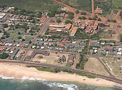
Aerial view of Kekaha
|
|

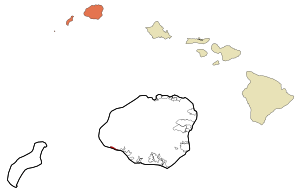
Location in Kauai County and the state of Hawaii
|
|
| Country | United States |
| State | Hawaii |
| County | Kauai |
| Area | |
| • Total | 1.29 sq mi (3.35 km2) |
| • Land | 1.00 sq mi (2.60 km2) |
| • Water | 0.29 sq mi (0.75 km2) |
| Elevation | 10 ft (3 m) |
| Population
(2020)
|
|
| • Total | 3,715 |
| • Density | 3,703.89/sq mi (1,430.32/km2) |
| Time zone | UTC-10 (Hawaii-Aleutian) |
| ZIP code |
96752
|
| Area code(s) | 808 |
| FIPS code | 15-35600 |
| GNIS feature ID | 0361086 |
Kekaha is a small community located on the island of Kauai in Hawaii. Its name means "the place" in the Hawaiian language. It is a special type of community called a census-designated place (CDP). This means it's an area identified by the U.S. Census Bureau for statistical purposes. In 2020, about 3,715 people lived in Kekaha.
Contents
History of Kekaha
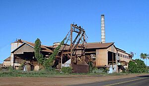
For most of the 1900s, the Kekaha Sugar Mill was very important to the area. It was owned by a company called Amfac. The mill helped Kekaha grow by providing jobs, housing, and even services like water and electricity. Many families in Kekaha worked at the sugar mill for generations.
However, the sugar industry in Hawaii faced challenges. The Kekaha Sugar Mill finally closed in the year 2000. This was part of a larger trend where sugar production stopped across Hawaii. In 2005, new owners bought the mill. They sold its large machines to other mills, even as far away as Africa.
Kekaha was also the site of Hawaii's only train robbery! This happened in February 1920. A masked person stopped a slow-moving sugar train. They got away with the train's engine and $11,000 that was meant to pay workers. Police later found the money in a swamp. A local fisherman was arrested and found guilty. People thought he was inspired by Western movies he had watched.
Geography and Location
Kekaha is found on the southwest side of the island of Kauai. It is located at coordinates 21°58′18″N 159°42′59″W. To the east of Kekaha is the town of Waimea. To the south, Kekaha borders the Pacific Ocean.
Hawaii Route 50 is a main road that goes through Kekaha. If you go northwest on this road for about 7 miles, you will reach the Pacific Missile Range Facility. If you go east for about 15 miles, you will get to Kalaheo.
The U.S. Census Bureau says that Kekaha covers a total area of about 3.4 square kilometers (1.29 square miles). Most of this area, about 2.6 square kilometers (1.00 square mile), is land. The rest, about 0.8 square kilometers (0.29 square miles), is water.
Kekaha's Climate
Kekaha has a hot semi-arid climate. This means it's generally warm and dry. The weather station near the Pacific Missile Range Facility, about 7 miles from town, collects climate data.
On average, Kekaha gets about 17.84 inches of rain each year. The summer months are usually the driest time of year. Winter is when Kekaha gets most of its rain. December is typically the wettest month, while August is the driest.
| Climate data for Pacific Missile Range Facility, 1991–2020 normals, extremes 1949–2015 | |||||||||||||
|---|---|---|---|---|---|---|---|---|---|---|---|---|---|
| Month | Jan | Feb | Mar | Apr | May | Jun | Jul | Aug | Sep | Oct | Nov | Dec | Year |
| Record high °F (°C) | 86 (30) |
87 (31) |
87 (31) |
90 (32) |
90 (32) |
93 (34) |
93 (34) |
93 (34) |
93 (34) |
92 (33) |
90 (32) |
88 (31) |
93 (34) |
| Mean maximum °F (°C) | 83.1 (28.4) |
83.1 (28.4) |
84.7 (29.3) |
85.7 (29.8) |
86.7 (30.4) |
88.1 (31.2) |
90.0 (32.2) |
90.2 (32.3) |
89.6 (32.0) |
89.2 (31.8) |
87.0 (30.6) |
85.3 (29.6) |
91.1 (32.8) |
| Mean daily maximum °F (°C) | 79.1 (26.2) |
79.2 (26.2) |
80.5 (26.9) |
82.2 (27.9) |
83.6 (28.7) |
85.7 (29.8) |
86.5 (30.3) |
87.5 (30.8) |
87.2 (30.7) |
86.0 (30.0) |
83.5 (28.6) |
81.6 (27.6) |
83.5 (28.6) |
| Daily mean °F (°C) | 72.0 (22.2) |
71.8 (22.1) |
73.0 (22.8) |
74.4 (23.6) |
76.1 (24.5) |
78.1 (25.6) |
78.9 (26.1) |
80.1 (26.7) |
79.7 (26.5) |
78.6 (25.9) |
76.1 (24.5) |
74.3 (23.5) |
76.1 (24.5) |
| Mean daily minimum °F (°C) | 64.9 (18.3) |
64.4 (18.0) |
65.5 (18.6) |
66.6 (19.2) |
68.6 (20.3) |
70.5 (21.4) |
71.2 (21.8) |
72.7 (22.6) |
72.2 (22.3) |
71.2 (21.8) |
68.7 (20.4) |
67.0 (19.4) |
68.6 (20.3) |
| Mean minimum °F (°C) | 58.3 (14.6) |
58.2 (14.6) |
59.7 (15.4) |
61.4 (16.3) |
63.8 (17.7) |
66.7 (19.3) |
67.8 (19.9) |
69.2 (20.7) |
68.4 (20.2) |
66.9 (19.4) |
63.9 (17.7) |
60.9 (16.1) |
57.0 (13.9) |
| Record low °F (°C) | 54 (12) |
54 (12) |
55 (13) |
57 (14) |
59 (15) |
63 (17) |
64 (18) |
65 (18) |
64 (18) |
58 (14) |
57 (14) |
53 (12) |
53 (12) |
| Average precipitation inches (mm) | 1.92 (49) |
2.64 (67) |
1.66 (42) |
0.60 (15) |
1.19 (30) |
0.60 (15) |
0.29 (7.4) |
0.27 (6.9) |
0.78 (20) |
1.82 (46) |
2.62 (67) |
3.45 (88) |
17.84 (453) |
| Average precipitation days (≥ 0.01 inch) | 7.8 | 5.7 | 6.3 | 6.2 | 4.7 | 4.2 | 3.6 | 3.2 | 5.6 | 6.5 | 5.7 | 7.3 | 66.8 |
| Source: NOAA (mean maxima/minima 1981–2010) | |||||||||||||
People of Kekaha
| Historical population | |||
|---|---|---|---|
| Census | Pop. | %± | |
| 2000 | 3,175 | — | |
| 2020 | 3,715 | — | |
| U.S. Decennial Census | |||
In 2000, there were 3,175 people living in Kekaha. By 2020, the population had grown to 3,715. There were 1,073 households in 2000. About 30.4% of these households had children under 18 living there. Many households, 55.9%, were married couples.
The people of Kekaha come from many different backgrounds. In 2000, about 43.6% of the population was Asian, and 12.4% were Pacific Islander. About 15.9% were White. Many people, 26.4%, identified as being from two or more races. About 8.7% of the population was Hispanic or Latino.
The average age of people in Kekaha in 2000 was 40 years old. About 25.1% of the population was under 18 years old. About 15.6% of the people were 65 years or older.
Interesting Places in Kekaha
Near Kekaha, you can find the U.S. Navy Pacific Missile Range Facility (PMRF). This is a very important military base. Inside PMRF, there is a special radio station called WWVH. This station is run by NIST. It broadcasts time signals from an atomic clock across the Pacific region. It also sends out weather alerts for parts of the Pacific Ocean.
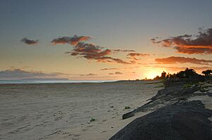
Kekaha Beach Park is a beautiful spot. From there, you can see amazing views of Niʻihau. This island is often called Hawaii's "Forbidden Island" because it is privately owned and access is very limited.
Schools in Kekaha
The Hawaii Department of Education manages the public schools in Kekaha.
- Kekaha Elementary School is one of the schools in the area.
There is also a special school called Niihau School of Kekaha. This is a charter school that teaches students from kindergarten all the way through 12th grade.
Communications History
Around 1962, there was an Army Radio Station a few miles west of Kekaha. This station was part of a large network of communication stations. This network stretched from California all the way to Vietnam. It used special radio waves to send messages, like TTY (teleprinter) traffic. This was important during the Vietnam War. The radio station stopped operating in 1967.
See also
 In Spanish: Kekaha para niños
 | May Edward Chinn |
 | Rebecca Cole |
 | Alexa Canady |
 | Dorothy Lavinia Brown |


