Pakala Village, Hawaii facts for kids
Quick facts for kids
Pakala Village, Hawaii
Pākalā Village
|
|
|---|---|

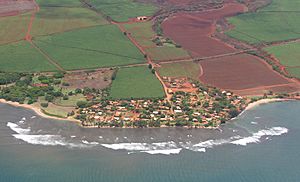
Aerial view of Pakala Village
|
|

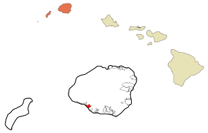
Location in Kauai County and the state of Hawaii
|
|
| Country | United States |
| State | Hawaii |
| County | Kauai |
| Area | |
| • Total | 2.74 sq mi (7.09 km2) |
| • Land | 2.40 sq mi (6.20 km2) |
| • Water | 0.34 sq mi (0.89 km2) |
| Elevation | 40 ft (10 m) |
| Population
(2020)
|
|
| • Total | 286 |
| • Density | 119.37/sq mi (46.09/km2) |
| Time zone | UTC-10 (Hawaii-Aleutian) |
| Area code(s) | 808 |
| FIPS code | 15-60350 |
| GNIS feature ID | 0362986 |
Pākalā Village, also known as Pākalā Camp, is a small community in Kauaʻi County, Hawaiʻi, United States. The name "Pākalā" means "the sun shines" in the Hawaiian language. It is called a census-designated place (CDP), which is a special area defined by the U.S. Census Bureau for collecting population data. In 2020, about 286 people lived there.
Contents
A Look at Pākalā Village History
Pākalā Village was once known as "Pākalā Camp." This name came from the temporary homes built for workers on a large farm called a plantation. These workers grew and harvested sugarcane.
The plantation was managed by the Robinson family, who first came to Hawaiʻi in 1863. Their farm, Gay & Robinson, was the very last sugarcane plantation on the island of Kauaʻi. The camp provided homes for both current and retired plantation workers.
Where is Pākalā Village Located?
Pākalā Village is found on the southwest coast of the island of Kauai. It sits right next to the Pacific Ocean. To its northwest is the town of Waimea.
The community of Pākalā Village is in the southwest part of the CDP. Another small community, Kaawanui Village, is in the northeast. Hawaii Route 50, a main highway, runs through the middle of the area, connecting these two settlements. This highway leads to Waimea and Kaumakani.
The total area of Pākalā Village is about 7.1 square kilometers (2.74 square miles). Most of this area is land, with a small part being water. The local post office for this area is called "Makaweli" and uses the ZIP code 96769.
Who Lives in Pākalā Village?
| Historical population | |||
|---|---|---|---|
| Census | Pop. | %± | |
| 2020 | 286 | — | |
| U.S. Decennial Census | |||
In 2020, the population of Pākalā Village was 286 people.
Back in 2000, there were 478 people living in the CDP. The community was made up of many different backgrounds. People from Asian and Pacific Islander heritage made up a large part of the population. There were also people who identified as White or from two or more races. A small percentage of the population was of Hispanic or Latino background.
The average household in Pākalā Village had about 3 people. Many families were married couples living together. The community had a mix of ages, from young children to older adults.
See also
 In Spanish: Pakala Village para niños
 | James B. Knighten |
 | Azellia White |
 | Willa Brown |

