
Tropical cyclone facts for kids


A tropical cyclone is a huge spinning storm that forms over warm ocean waters near the Earth's Equator. These powerful storms bring very fast winds and heavy rains. Some tropical cyclones stay over the sea, but others move onto land. They can be very dangerous because they cause floods and their strong winds can pick up and throw objects, even large ones like small boats, at high speeds.
Tropical cyclones, also known as hurricanes or typhoons, start when warm, moist air above the ocean rises. This happens when the ocean water is about 80 °F (27 °C) or warmer. As the air rises, the Earth's spin (called the Coriolis effect) makes the winds start to rotate. These storms usually travel west in tropical areas, and then might turn north or south into cooler regions. The calm center of the storm is called the "eye of the storm". It has little rain or wind. Around the eye is the "eyewall," which has the heaviest rain and the fastest winds. Outside the eyewall are rain bands that also have strong winds.
Tropical cyclones get their power from warm, humid ocean air. They lose strength when they move over land or cooler ocean water. They die out if they stay over land or cold water for too long.
Contents
- How Tropical Cyclones Get Their Names
- Types of Tropical Cyclones
- Different Names for Tropical Cyclones
- How Tropical Cyclones Form
- When Storms Get Stronger Quickly
- How Tropical Cyclones Weaken and Disappear
- Inside a Tropical Cyclone
- Impact and Damage
- Watching and Predicting Storms
- Getting Ready for a Storm
- Related pages
- Images for kids
- See also
How Tropical Cyclones Get Their Names
Tropical cyclones are given names to help people track them, predict where they're going, and report on them. A storm gets a name once its winds reach a steady speed of 62 km/h (39 mph). Groups from the World Meteorological Organization choose these names. Once a cyclone is named, it usually keeps that name.
For hundreds of years, hurricanes were named after saints. In 1887, an Australian weather expert named Clement Wragge started giving women's names to tropical cyclones. Later, during World War II, storms were named using the phonetic alphabet (like Able, Baker, Charlie). In 1953, the United States began using only female names for these storms. This changed in 1978 when both male and female names were used for storms in the Pacific. By 1979, this practice was also used for hurricanes in the Gulf of Mexico and the Atlantic Ocean.
Types of Tropical Cyclones
| Category | Wind speeds |
|---|---|
| Five | ≥70 m/s, ≥137 knots ≥157 mph, ≥252 km/h |
| Four | 58–70 m/s, 113–136 knots 130–156 mph, 209–251 km/h |
| Three | 50–58 m/s, 96–112 knots 111–129 mph, 178–208 km/h |
| Two | 43–49 m/s, 83–95 knots 96–110 mph, 154–177 km/h |
| One | 33–42 m/s, 64–82 knots 74–95 mph, 119–153 km/h |
| Tropical storm |
18–32 m/s, 34–63 knots 39–73 mph, 63–118 km/h |
|---|---|
| Tropical depression |
≤17 m/s, ≤33 knots ≤38 mph, ≤62 km/h |
Tropical cyclones are put into different groups based on how strong they are and where they form. The National Hurricane Center, which watches storms in the Atlantic and parts of the Pacific Ocean, uses the Saffir-Simpson Hurricane Scale to classify them.
Storms in other places, like the Western Pacific Ocean or the Southern Hemisphere, use similar scales. For example, a tropical storm in the western Pacific that reaches hurricane-strength winds is officially called a typhoon.
Tropical Depression
A tropical depression is an organized group of clouds and thunderstorms with a clear spinning motion near the ocean surface. Its strongest steady winds are less than 62 km/h (38 mph). It doesn't have an eye and usually doesn't look like the spiral shape of stronger storms. Only the Philippines usually name tropical depressions.
Tropical Storm
A tropical storm is an organized system of strong thunderstorms with a very clear spinning motion at the surface. Its steady winds are between 62 and 117 km/h (39–73 mph). At this stage, the storm starts to look like a cyclone, but it usually doesn't have a clear eye. Most weather agencies start naming storms when they reach this strength.
Hurricane, Typhoon, or Cyclone
A hurricane, typhoon, or cyclone is a large spinning weather system with steady winds of at least 118 km/h (74 mph). A tropical cyclone this strong usually develops an eye. The eye is a calm area at the center of the storm. From space, the eye often looks like a small, clear, round spot without clouds. Around the eye is the eyewall, where the strongest thunderstorms and winds spin around the storm's center. The fastest steady winds ever found in tropical cyclones are thought to be around 305 km/h (190 mph).
Different Names for Tropical Cyclones
The term "tropical cyclone" is a general name. In different parts of the world, these storms have other local names:
- In the Atlantic Ocean and the eastern, central, and northern Pacific Ocean, a tropical cyclone is called a hurricane.
- In the western Pacific, it's called a typhoon.
- In the Indian Ocean, it's simply called a "cyclone".
How Tropical Cyclones Form

Tropical cyclones usually form during the summer, but they can happen in almost any month in most tropical ocean areas. Storms on either side of the Equator often start in the Intertropical Convergence Zone. This is where winds from the northeast and southeast meet. In this wide area of low pressure, air gets heated over the warm tropical ocean and rises in separate pockets, forming thunderstorms. These storms often group together into large clusters. This creates a flow of warm, moist air that rises quickly and starts to spin as it interacts with the Earth's rotation.
Several things are needed for these thunderstorms to grow into a tropical cyclone:
- Ocean water temperatures must be around 27 °C (80 °F) or warmer.
- There needs to be low vertical wind shear around the storm. This means winds at different heights aren't blowing in too many different directions.
- The atmosphere needs to be unstable.
- There must be high humidity (lots of moisture) in the lower and middle parts of the troposphere.
- Enough Coriolis force is needed to help a low-pressure center develop.
- There needs to be an existing area of low pressure or a disturbance to start things off.
When Storms Get Stronger Quickly
Sometimes, tropical cyclones can get much stronger very fast. This is called rapid intensification. It means the storm's strongest steady winds increase by 56 km/h (35 mph) or more within 24 hours. For this to happen, the ocean water must be extremely warm (near or above 30 °C or 86 °F). Also, this warm water needs to be deep enough so that waves don't bring cooler water up to the surface.
How Tropical Cyclones Weaken and Disappear

A tropical cyclone can weaken or lose its tropical features in several ways. This includes moving over land, going over cooler water, running into dry air, or interacting with other weather systems. However, even after a storm weakens, its leftover parts could sometimes form a new tropical cyclone if conditions become right again.
A tropical cyclone can weaken when it moves over waters that are much cooler than 26.5 °C (79.7 °F). This takes away the warm, moist air the storm needs, causing it to lose its warm center and thunderstorms. It then becomes a leftover area of low pressure. These leftover systems can last for several days before completely disappearing. This way of weakening is most common in the eastern North Pacific.
If a tropical cyclone moves over land or an island, its spinning motion can start to break down, especially if it hits mountains. When a storm makes landfall on a large landmass, it loses its supply of warm, moist ocean air and starts to pull in dry air from the land. This, along with more friction over land, causes the storm to weaken and disappear. Over mountains, a storm can weaken very quickly. Over flat areas, it might last for two to three days before breaking apart.
Over the years, people have thought about ways to try and change tropical cyclones. These ideas included using nuclear weapons, cooling the ocean with icebergs, blowing the storm away with giant fans, or seeding storms with dry ice or silver iodide. However, these methods don't consider how long, how strong, how powerful, or how big tropical cyclones really are.
Inside a Tropical Cyclone
The Eye and Center

At the center of a strong tropical cyclone, air actually sinks instead of rising. In a very strong storm, this sinking air can go deep enough to stop clouds from forming, creating a clear "eye". The weather in the eye is usually calm and clear, even though the ocean below might be very rough. The eye is usually round and is typically 30–65 km (19–40 mi) wide. However, eyes as small as 3 km (2 mi) and as large as 370 km (230 mi) have been seen.
The cloudy outer edge of the eye is called the "eyewall". The eyewall usually slopes outward as it goes higher, looking a bit like a sports stadium. This is sometimes called the "stadium effect". The eyewall is where the fastest winds are found, air rises most quickly, clouds reach their highest points, and rain is heaviest. The worst wind damage happens when a tropical cyclone's eyewall passes over land.
In a weaker storm, the eye might be hidden by the central dense overcast. This is a shield of high-level clouds that covers a strong area of thunderstorms near the storm's center.
The eyewall can change over time through eyewall replacement cycles, especially in very strong tropical cyclones. Outer rainbands can form into an outer ring of thunderstorms that slowly moves inward. This is thought to take moisture and energy from the main eyewall. When the main eyewall weakens, the storm temporarily loses some strength. The outer eyewall eventually replaces the main one, and then the storm might get back to its original strength.
How Big Are They?
Tropical cyclones come in many different sizes, from 100 km (62 mi) to 2000 km (1243 mi) across. They are generally largest in the northwest Pacific Ocean and smallest in the northeastern Pacific Ocean.
| Size descriptions of tropical cyclones | |
|---|---|
| Diameter | Type |
| Less than 222 km (138 mi) | Very small/minor |
| 222 to 333 km (138 to 207 mi) | Small |
| 333 to 670 km (207 to 416 mi) | Medium/Average/Normal |
| 670 to 888 km (416 to 552 mi) | Large |
| Over 888 km (552 mi) | Very large |
The size of a storm doesn't always mean it's stronger or weaker. Typhoon Tip was the largest cyclone ever recorded, with tropical storm-force winds stretching 2170 km (1348 mi) across. The smallest storm on record was Tropical Storm Marco in 2008, which had tropical storm-force winds only 37 km (23 mi) wide.
Impact and Damage

In the past, these storms sank many ships. But better weather forecasting in the 20th century helped most ships avoid them. When tropical cyclones reach land, they can cause a lot of damage. Sometimes they kill people and destroy towns. In the last 200 years, about 1.5 million people have died because of tropical cyclones.
Strong winds can cause most of the damage from a storm. Broken pieces from destroyed objects can become dangerous flying debris. Flooding can also happen when a lot of rain falls or when storm surges (a rise in sea level caused by the storm) push water onto the land.
Sometimes, people can die "indirectly" after a tropical cyclone passes. For example, New Orleans, Louisiana had poor health conditions after Hurricane Katrina hit in 2005.
Watching and Predicting Storms
How We Watch Storms

_at_SENEX_Air_Quality-Climate_Research_Study_(9119691512).jpg)
For thousands of years, tropical cyclones have happened all over the world. But before satellites were available in the 20th century, there was no way to know about a tropical cyclone unless it hit land or a ship found it by chance.
Strong tropical cyclones are hard to observe because they are dangerous and happen over the ocean, far from weather stations. Usually, we only get measurements from the edges of the storm, where conditions are not as bad. Because of this, teams of weather experts sometimes go into the path of tropical cyclones to help measure their strength when they hit land.
Tropical cyclones are tracked by weather satellites that take pictures from space every 15 to 30 minutes. As a storm gets close to land, it can be watched by land-based Doppler weather radar. Radar is very important near landfall because it shows the storm's location and strength every few minutes. Other satellites use GPS signals to provide thousands of daily snapshots of atmospheric temperature, pressure, and moisture.
Special planes called "hurricane hunters" can fly directly into the cyclone to take measurements. These planes also drop special devices called GPS dropsondes inside the storm. These devices measure temperature, humidity, pressure, and especially winds from the plane's height down to the ocean's surface. A new way to observe hurricanes started when a small drone aircraft, an Aerosonde, flew through Tropical Storm Ophelia in 2005.

Predicting Storms
Fast computers and advanced software help forecasters create computer models that predict where tropical cyclones will go. These models use information about future high- and low-pressure systems. By combining these models with a better understanding of how tropical cyclones work, and with lots of data from satellites and other sensors, scientists have made storm track predictions much more accurate in recent years. However, scientists are not as good at predicting how strong tropical cyclones will become. This is because tropical systems are very complex, and we don't fully understand all the things that affect their strength. New storm location and prediction information is available at least every six hours from different warning centers.
Getting Ready for a Storm

Before the storm season even begins, leaders and weather forecasters encourage people to prepare for a tropical cyclone. This means finding out what risks they face from different types of weather, checking their insurance, getting emergency supplies, and deciding where to go if they need to leave their homes. When a tropical cyclone forms and is expected to hit land, each country that is part of the World Meteorological Organization issues different watches and warnings to tell people about the expected effects.
An important decision for families is figuring out if and when to leave an area that will be hit by a tropical cyclone. Tracking charts allow people to follow storms themselves. This helps them decide where the storms are going and if they need to get ready, including possibly leaving. This is still encouraged by the National Oceanic and Atmospheric Administration and National Hurricane Center.
Related pages
Images for kids
-
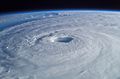
Hurricane Isabel (2003) as seen from orbit during Expedition 7 of the International Space Station. The eye, eyewall, and surrounding rainbands are clearly visible.
-
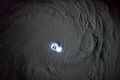
Thunderstorm activity in the eyewall of Cyclone Bansi as seen from the International Space Station, on January 12, 2015.
-
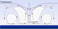
Tropical cyclones show a circulation where air flows in low down, rises in thunderstorms, and flows out high up.
-
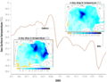
Chart showing the drop in surface temperature in the Gulf of Mexico as Hurricanes Katrina and Rita passed over.
-
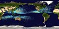
Map of all tropical cyclone paths from 1985–2005. The Pacific Ocean west of the International Date Line has more tropical cyclones than any other area.
-
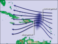
Waves in the trade winds in the Atlantic Ocean create conditions that can lead to hurricanes.
-
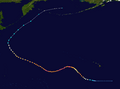
Storm path of Typhoon Ioke, showing its turn off the Japanese coast in 2006.
-
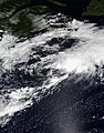
Tropical Storm Kyle, in 2020, is an example of a sheared tropical cyclone, with deep convection a couple hundred miles from the center.
-
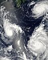
Three tropical cyclones from 2006 at different stages. The weakest (left) shows a basic circular shape. A stronger storm (top right) shows spiral banding, while the strongest (lower right) has developed an eye.
-
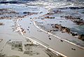
Flooding after the 1991 Bangladesh cyclone, which killed around 140,000 people.
-
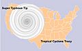
The relative sizes of Typhoon Tip, Cyclone Tracy, and the Contiguous United States.
-
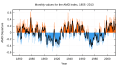
Atlantic Multidecadal Oscillation Timeseries, 1856–2013.


See also
 In Spanish: Ciclón tropical para niños
