Contiguous United States facts for kids
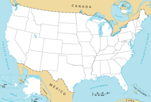
The contiguous United States refers to the 48 states that are connected to each other. It also includes Washington, D.C., which is the capital city. These states form one large, connected area on the map.
This term helps us talk about the main part of the country. It does not include Alaska or Hawaii, because they are separated from the other states. Alaska is far to the northwest, and Hawaii is a group of islands in the Pacific Ocean.
It also does not include other places that belong to the U.S., like Puerto Rico or the United States Virgin Islands. These are called U.S. territories and are also separated by water.
Contents
Understanding the Contiguous US
The word "contiguous" means "touching" or "next to each other." So, the contiguous United States are the states that share a border with another state. This makes them one big landmass.
For example, California touches Oregon and Nevada. Texas touches Oklahoma, Arkansas, and Louisiana. All these states are part of the contiguous group.
Why is this Term Important?
People use the term "contiguous United States" to be clear about which parts of the country they are talking about. Sometimes, when people say "the U.S.," they might only be thinking of the main 48 states.
For example, if a weather report says "snow across the contiguous U.S.," it means snow is expected in the connected states, but not necessarily in Alaska or Hawaii. It helps avoid confusion.
States Not Included
Two states are not part of the contiguous United States:
- Alaska: This state is located far to the northwest of Canada. It is the largest state by land area.
- Hawaii: This state is a group of islands in the Pacific Ocean. It is located thousands of miles southwest of the mainland.
Also, several U.S. territories are not included. These are places that are governed by the United States but are not states. They include:
These territories are often islands and are not connected to the main landmass of the U.S.
Fun Facts About the Contiguous US
The contiguous United States covers a huge area. It stretches from the Atlantic Ocean on the east to the Pacific Ocean on the west. It also goes from the border with Canada in the north to the border with Mexico in the south.
Size and Geography
The total land area of the contiguous United States is about 3.1 million square miles (8.0 million square kilometers). This makes it the third-largest country in the world by total area, after Russia and Canada.
Within this area, you can find many different types of landscapes. There are tall mountains, vast deserts, wide plains, and long coastlines. This variety makes the contiguous U.S. very diverse in its geography and climate.
Population and Cities
Most of the U.S. population lives within the contiguous states. Major cities like New York City, Los Angeles, Chicago, and Houston are all located here. These cities are centers for business, culture, and education.
The contiguous U.S. is home to nearly 330 million people. This makes it one of the most populated countries in the world. People from all over the globe have made their homes in these connected states.
See also
 In Spanish: Estados Unidos contiguos para niños
 | Selma Burke |
 | Pauline Powell Burns |
 | Frederick J. Brown |
 | Robert Blackburn |


