
Guam facts for kids
Quick facts for kids
Guam
Guåhan (Chamorro)
|
|||
|---|---|---|---|
|
|||
| Nickname(s): | |||
| Motto(s): | |||
| Anthem: "Kantikun Guåhan" (Chamorro) ("Guam Hymn") (regional) "The Star-Spangled Banner" (official) |
|||

Location of Guam (circled in red)
|
|||
| Sovereign state | United States | ||
| Before annexation | Spanish East Indies | ||
| Cession from Spain | December 10, 1898 | ||
| Capital | Hagåtña | ||
| Largest city | Dededo | ||
| Official languages |
|
||
| Ethnic groups
(2010)
|
|||
| Religion
(2010)
|
|
||
| Demonym(s) | Guamanian | ||
| Government | Devolved presidential dependency within a federal republic | ||
|
• President
|
Donald Trump (R) | ||
|
• Governor
|
Lou Leon Guerrero (D) | ||
|
• Lieutenant Governor
|
Josh Tenorio (D) | ||
| Legislature | Legislature of Guam | ||
| Area | |||
|
• Total
|
210 sq mi (540 km2) | ||
| Highest elevation | 1,334 ft (407 m) | ||
| Population | |||
|
• 2021 estimate
|
168,801 (177th) | ||
|
• Density
|
299/km2 (774.4/sq mi) | ||
| GDP (PPP) | 2016 estimate | ||
|
• Total
|
$5.8 billion | ||
|
• Per capita
|
$35,600 | ||
| GDP (nominal) | 2019 estimate | ||
|
• Total
|
$6.3 billion | ||
|
• Per capita
|
$37,387 | ||
| HDI (2017) | very high |
||
| Currency | United States dollar (US$) (USD) | ||
| Time zone | UTC+10:00 (ChST) | ||
| Date format | mm/dd/yyyy | ||
| Driving side | right | ||
| Calling code | +1 | ||
| USPS abbreviation |
GU
|
||
| ISO 3166 code |
|
||
| Internet TLD | .gu | ||
| Patron Saint | Our Lady of Camarin | ||


Guam (pronounced GWAHM) is a beautiful island in the western Pacific Ocean. It is an organized, unincorporated territory of the United States. This means it's part of the U.S. but doesn't have all the same rights as a state. The capital of Guam is Hagåtña, and its largest village is Dededo.
Guam is the westernmost point of the U.S. It is also the largest and southernmost island in the Mariana Islands chain. In 2022, about 168,801 people lived there. The native people are called the Chamorro. They are the largest ethnic group, but many other groups also live on the island. Guam covers about 210 square miles (544 square kilometers).
The Chamorro people are related to the Austronesian peoples from places like the Philippines and Polynesia. They settled Guam about 3,500 years ago. The Chamorro language is unique and different from most nearby island languages.
The first European to see Guam was Portuguese explorer Ferdinand Magellan in 1521. Spain officially claimed the island in 1565 and fully colonized it in 1668. For centuries, Guam was an important stop for Spanish ships traveling across the Pacific. The United States took control of Guam in 1898 during the Spanish–American War. Spain then gave Guam to the U.S. in 1899.
During World War II, Japanese forces captured Guam in December 1941. They occupied the island for two and a half years. American forces recaptured Guam on July 21, 1944. This day is now celebrated as Liberation Day.
Since the 1960s, Guam's economy has grown thanks to tourism and the U.S. military. The military sees Guam as a very important location. There have been many discussions about Guam's future political status, with many people wanting it to become an American state.
Guam's unofficial motto is "Where America's Day Begins." This is because of its location near the International Date Line. Guam is also listed by the United Nations as one of the non-self-governing territories. It has been a member of the Pacific Community since 1983.
The Chamorro name for Guam is Guåhan. This comes from the word guaha, meaning 'to have'. It suggests that the island provides everything needed for life.
Contents
Guam's History
Ancient Chamorro Life

Guam and the other Mariana Islands were the first islands in Remote Oceania to be settled by humans. These early settlers were Austronesian peoples who traveled long distances across the ocean. They first arrived around 1500 to 1400 BC, coming from the Philippines. Later, more people arrived from the Caroline Islands and Island Southeast Asia.
These first settlers became the Chamorro people. Ancient Chamorro society had four main groups:
- Chamori: Chiefs
- Matua: Upper class, living in coastal villages with good fishing access
- Achaot: Middle class, often helping the Matua
- Mana'chang: Lower class, living in the island's interior
The Chamorro people also had special healers called suruhånu or suruhåna. These healers used plants and natural materials to make medicine. Many Chamorros still believe in spirits of their ancestors, called Taotao mo'na.
The Chamorro people built their homes on top of large stone pillars called latte stones. These unique stone pillars are only found in the Mariana Islands. Latte stones have a limestone base called a haligi and a capstone called a tåsa.
Spanish Rule
Portuguese explorer Ferdinand Magellan was the first European to see Guam in March 1521. Spain officially claimed the island in 1565. From 1565 to 1815, Guam was an important stop for Spanish ships called Manila galleons. These ships sailed between Acapulco, Mexico, and Manila, Philippines.
Spanish colonization began in 1668 when a mission led by Diego Luis de San Vitores arrived. He established the first Catholic church on the island. Guam became part of the Spanish East Indies, governed from Mexico City. Conflicts between the Chamorro people and the Spanish mission began in 1670.
Over time, warfare, typhoons, and diseases like smallpox greatly reduced the Chamorro population. By the early 1800s, the population was much smaller. In the 1800s, Guam also became a rest stop for whaling ships.
American Era Begins
.jpg)
After nearly 400 years under Spain, the United States took control of Guam in 1898. This happened after Spain lost the Spanish–American War. Guam was officially transferred to the United States Navy in December 1898.
The U.S. Navy then managed Guam, with Captain Richard P. Leary becoming the first naval governor in 1899. The Navy worked to improve Guam's roads, sanitation, and public health. They also started public schools where English was taught. Chamorro leaders asked for U.S. citizenship and more self-governance, but these requests were not granted at that time.
Guam in World War I
In 1914, a German ship, the SMS Cormoran, sought shelter in Guam's Apra Harbor. The U.S. was neutral then and did not provide enough supplies for the ship to leave. So, the ship and its crew stayed in Guam.
On April 7, 1917, the U.S. declared war on Germany. The U.S. Navy in Guam informed the Cormoran that its crew were now prisoners of war. The German captain refused to surrender his ship. Soon after, an explosion happened on the Cormoran, and the crew abandoned ship. American sailors rescued most of the German crew. This event marked the first shots fired by the U.S. against Germany in World War I.
Guam in World War II

During World War II, Japanese forces invaded and captured Guam on December 8, 1941. This was just hours after the attack on Pearl Harbor. The Japanese occupied Guam for about two and a half years. During this time, the Chamorro people faced harsh conditions and suffering.
American forces returned and recaptured the island in the 1944 Battle of Guam, from July 21 to August 10. July 21 is now celebrated as Liberation Day.
After World War II
After the war, the Guam Organic Act of 1950 made Guam an unincorporated organized territory of the United States. This act set up Guam's civilian government and gave U.S. citizenship to its people. However, citizens in Guam could not vote for president and had only a non-voting representative in the U.S. Congress.
The governor of Guam was appointed by the federal government until 1968. That year, the Guam Elective Governor Act allowed people to elect their own governor. In 1969, Guam held a vote on joining with the Northern Mariana Islands, but the idea was rejected.
In 1963, President John F. Kennedy removed a security clearance requirement for Guam. This helped the island's tourism industry grow. In the early 1990s, many U.S. military forces from the Philippines moved to Guam.
Guam's economy faced challenges in the late 1990s and early 2000s. This was due to an Asian financial crisis, military cutbacks, and powerful typhoons like Paka (1997) and Pongsona (2002). The September 11, 2001 attacks also affected tourism.
Guam's Geography and Environment

Guam is about 30 miles (48 kilometers) long and 4 to 12 miles (6 to 19 kilometers) wide. It covers an area of 212 square miles (549 square kilometers). It is the 32nd largest island in the United States. Guam is the southernmost and largest island in the Mariana Islands and the largest in Micronesia. Point Udall in Guam is the westernmost point of the U.S.
The Mariana Islands chain, including Guam, was formed by the collision of huge tectonic plates. Guam sits on the smaller Mariana Plate. It is also the closest land to the Mariana Trench, which is the deepest part of the world's oceans.
The northern part of Guam is a plateau made of limestone from ancient coral reefs. The rugged southern part of the island was formed by more recent volcanic activity. Cocos Island is a small islet off Guam's southern tip. Guam's highest point is Mount Lamlam, which is 1,334 feet (407 meters) above sea level.
Guam is divided into 19 villages. Most people live on the northern limestone plateaus. The western coast is home to Apra Harbor, the capital Hagåtña, and the tourist area of Tumon. The U.S. Defense Department owns about 29% of the island.
Guam's Climate

Guam has a tropical rainforest climate, meaning it's generally hot and humid all year. Temperatures don't change much throughout the seasons. Trade winds blow steadily, and sometimes there's a weak monsoon in the summer.
Guam has two main seasons:
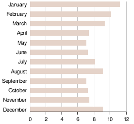
- Dry season: From December to May.
- Wet season: From July to November. June is a transition month.
The island gets a lot of rain, with an average of 98 inches (2,489 mm) per year. The wettest month on record was August 1997, with 38.49 inches (978 mm) of rain.
Temperatures usually stay between 70°F (21°C) and 90°F (32°C). The air is often very humid, especially at night.
Guam is in the path of typhoons, which are strong tropical storms. The highest risk for typhoons is from August to November, but they can happen any time of year. Major typhoons that caused damage include Karen (1962), Pamela (1976), Paka (1997), Pongsona (2002), and Mawar (2023).
After Typhoon Pamela in 1976, many wooden buildings were replaced with stronger concrete ones. Stricter building codes now require homes and businesses to be built with reinforced concrete and typhoon shutters.
| Climate data for Guam International Airport (1991–2020 normals, extremes 1945–present) | |||||||||||||
|---|---|---|---|---|---|---|---|---|---|---|---|---|---|
| Month | Jan | Feb | Mar | Apr | May | Jun | Jul | Aug | Sep | Oct | Nov | Dec | Year |
| Record high °F (°C) | 94 (34) |
93 (34) |
93 (34) |
96 (36) |
94 (34) |
95 (35) |
95 (35) |
94 (34) |
94 (34) |
93 (34) |
92 (33) |
91 (33) |
96 (36) |
| Mean maximum °F (°C) | 88.4 (31.3) |
88.5 (31.4) |
89.2 (31.8) |
90.2 (32.3) |
90.8 (32.7) |
91.1 (32.8) |
90.8 (32.7) |
90.6 (32.6) |
90.4 (32.4) |
90.4 (32.4) |
89.9 (32.2) |
88.8 (31.6) |
92.0 (33.3) |
| Mean daily maximum °F (°C) | 85.7 (29.8) |
85.7 (29.8) |
86.7 (30.4) |
87.9 (31.1) |
88.5 (31.4) |
88.5 (31.4) |
87.7 (30.9) |
87.0 (30.6) |
87.0 (30.6) |
87.2 (30.7) |
87.4 (30.8) |
86.6 (30.3) |
87.2 (30.7) |
| Daily mean °F (°C) | 80.3 (26.8) |
80.1 (26.7) |
81.0 (27.2) |
82.3 (27.9) |
83.0 (28.3) |
83.1 (28.4) |
82.2 (27.9) |
81.5 (27.5) |
81.5 (27.5) |
81.7 (27.6) |
82.2 (27.9) |
81.6 (27.6) |
81.7 (27.6) |
| Mean daily minimum °F (°C) | 75.0 (23.9) |
74.6 (23.7) |
75.4 (24.1) |
76.7 (24.8) |
77.5 (25.3) |
77.7 (25.4) |
76.8 (24.9) |
76.1 (24.5) |
76.0 (24.4) |
76.3 (24.6) |
77.0 (25.0) |
76.5 (24.7) |
76.3 (24.6) |
| Mean minimum °F (°C) | 71.6 (22.0) |
71.4 (21.9) |
71.9 (22.2) |
73.3 (22.9) |
74.1 (23.4) |
74.6 (23.7) |
73.8 (23.2) |
73.4 (23.0) |
73.3 (22.9) |
73.4 (23.0) |
73.9 (23.3) |
73.3 (22.9) |
70.2 (21.2) |
| Record low °F (°C) | 66 (19) |
65 (18) |
66 (19) |
68 (20) |
70 (21) |
70 (21) |
70 (21) |
70 (21) |
70 (21) |
67 (19) |
68 (20) |
68 (20) |
65 (18) |
| Average precipitation inches (cm) | — | 4.15 (10.5) |
2.77 (7.0) |
3.50 (8.9) |
4.45 (11.3) |
6.51 (16.5) |
12.25 (31.1) |
17.66 (44.9) |
15.17 (38.5) |
12.73 (32.3) |
8.29 (21.1) |
5.30 (13.5) |
98.12 (249.2) |
| Average precipitation days (≥ 0.01 in) | 20.1 | 18.0 | 18.3 | 18.9 | 19.7 | 23.2 | 26.0 | 25.9 | 25.1 | 25.4 | 23.9 | 22.7 | 267.2 |
| Average relative humidity (%) | 83.7 | 81.9 | 83.1 | 82.0 | 82.7 | 82.7 | 87.3 | 88.7 | 88.8 | 88.3 | 86.6 | 83.0 | 84.9 |
| Mean monthly sunshine hours | 176.0 | 173.7 | 216.4 | 214.0 | 219.9 | 193.8 | 156.1 | 142.2 | 132.7 | 132.6 | 135.0 | 143.4 | 2,035.8 |
| Percent possible sunshine | 50 | 53 | 58 | 57 | 56 | 50 | 39 | 37 | 36 | 36 | 39 | 41 | 46 |
| Source: NOAA (relative humidity and sun 1961–1990) | |||||||||||||
Guam's Plants and Animals

Guam has many different natural environments, including coral reefs, deep seas, and various types of forests. About 17 plant species are found only on Guam. Many more are unique to the Mariana Islands. The island also has many unique insects and about 29 types of land snails. Sadly, many of these snails are now endangered or have disappeared.
Guam once had 14 kinds of native birds. Seven of these were found only on Guam. However, almost all of these native birds are now extinct, gone from the island, or endangered. The Guam rail is one success story; it was brought back from being extinct in the wild after a population was started on Cocos Island.
.jpg)
One big problem for Guam's wildlife is invasive species. The brown tree snake was introduced to the island and almost completely wiped out the native bird population. Other invasive species, like the coconut rhinoceros beetle, harm coconut trees.
Wildfires are also a problem during the dry season, even though Guam is humid. Most fires are started by people, often by poachers. These fires destroy forests and lead to soil erosion.
Protecting Guam's coral reefs is very important. These reefs are home to many marine animals and are popular for scuba divers. The government has created several marine preserves to protect these areas. The Guam National Wildlife Refuge in northern Guam helps protect sea turtles and Mariana fruit bats.
Guam's People and Culture
Population and Languages
| Historical population | |||
|---|---|---|---|
| Census | Pop. | %± | |
| 1910 | 11,806 | — | |
| 1920 | 13,275 | 12.4% | |
| 1930 | 18,509 | 39.4% | |
| 1940 | 22,290 | 20.4% | |
| 1950 | 59,498 | 166.9% | |
| 1960 | 67,044 | 12.7% | |
| 1970 | 84,996 | 26.8% | |
| 1980 | 105,979 | 24.7% | |
| 1990 | 133,152 | 25.6% | |
| 2000 | 154,805 | 16.3% | |
| 2010 | 159,358 | 2.9% | |
| 2020 | 168,485 | 5.7% | |
In the 2020 United States census, the largest group of people were the native Chamorros, making up 32.8% of the population. Asians, including Filipinos, Koreans, Chinese, and Japanese, were 35.5%. Other groups from Micronesia made up 13.2%. About 10% of the population were multiracial. European Americans were 6.8%, and African Americans were 1%. About 3% of the population were Hispanic.
The official languages of Guam are English and Chamorro. The Chamorro language is unique and not like most other languages in the area. Filipino is also commonly spoken. Spanish, which was used for 300 years, is not widely spoken anymore, but it greatly influenced the Chamorro language.
Religion in Guam
Most people in Guam are Christian. About three-quarters of the population are Catholic. Most of the remaining people belong to Protestant churches. According to the Pew Research Center, in 2010, the religious groups were:
- Catholicism: 75%
- Protestantism: 17.7%
- Other religions: 1.6%
- Folk religions: 1.5%
- Other Christianity: 1.4%
- Buddhism: 1.1%
- Eastern Orthodoxy: <1%
- Hinduism: <1%
- Islam: <1%
- Judaism: <1%
In 2020, the Vatican reported that 87.72% of the population was Catholic.
Guam's Culture
.jpg)
Guam's culture is a mix of traditional Chamorro customs and influences from American, Spanish, and Mexican traditions. After Europeans arrived, many ancient Chamorro customs changed. However, there is a growing interest in preserving the Chamorro language and culture today.
Spanish influences can be seen in the local language, music, dance, and food. The Chamorro people have lived on Guam for almost 4,000 years. They had their own language, similar to languages in Indonesia and Southeast Asia. The Spanish later called them Chamorros, which comes from a word meaning "noble race."
_(cropped).jpg)
Historically, the Chamorro people honored their ancestors. During Spanish rule, most people became Catholic. Many Chamorros have Spanish last names, even if they are not directly descended from Spaniards. This happened after they converted to Catholicism.
The traditional Chamorro diet included fish, fowl, rice, breadfruit, taro, yams, bananas, and coconuts. After contact with the Spanish, corn-based foods like tortillas and tamales became common.
Sports in Guam
.jpg)
The most popular sport in Guam is American football, followed by basketball and baseball. Soccer, jiu-jitsu, and rugby are also popular. Guam hosted the Pacific Games in 1975 and 1999.
Guam's men's and women's national basketball teams are strong competitors in the Oceania region. The men's team was the champion of the Pacific Games Basketball Tournament in 2019.
The Guam national football team was formed in 1975. It won its first game against a FIFA-registered team in 2009. In 2015, Guam hosted its first FIFA World Cup-qualifying games.
Guam's Economy
.jpg)
Guam's economy mainly relies on tourism, U.S. Department of Defense facilities, and local businesses. The federal income taxes paid by people in Guam go to Guam's treasury, not the U.S. treasury.
Tourism in Guam
 |
Guam is a popular place for tourists, especially from Japan and South Korea. The main tourist area, Tumon, has many hotels, shops, and entertainment. The island is a short flight from Asia and attracts over a million tourists each year.
Most tourists are Japanese, but many also come from South Korea, the U.S., the Philippines, and Taiwan. In May and June 2024, South Korean visitors made up over 51% of arrivals. Japanese tourists were over 21%.
The COVID-19 pandemic greatly affected Guam's tourism. In 2023, there were about 656,000 visitors, which was less than in 2013. However, tourism has been recovering. In the 2024 fiscal year (October–July), 775,000 passengers arrived at the Guam International Airport.
Tourism is a very important part of Guam's economy. It provides over 21,000 jobs, which is about one-third of the island's workforce.

Jobs and Economic Support
In 2003, Guam had a 14% unemployment rate. By 2019, it had dropped to 6.1%. In September 2020, the rate rose to 17.9%. By June 2023, it had fallen to 4.0%. In September 2023, the unemployment rate was 4.1%.
Many people from other Pacific islands have moved to Guam. This is due to agreements called Compacts of Free Association (COFA). These agreements allow citizens from certain island nations to live in the U.S. and its territories. Aid has been provided to Guam to help with the impact of this migration. In 2024, the COFA was updated to continue this aid.
Military Bases in Guam
.jpg)
The Joint Region Marianas manages U.S. military bases that cover about 29% of Guam's land. These include:
- Naval Base Guam (U.S. Navy)
- Andersen Air Force Base (U.S. Air Force)
- Marine Corps Base Camp Blaz (U.S. Marine Corps)
- Other important naval and air force facilities.
In 2010, the U.S. military planned to move many Marines and their families to Guam from Okinawa, Japan. This would have greatly increased Guam's population. The United States Environmental Protection Agency raised concerns about water and sewage. By 2022, the Marine Corps decided to place 5,000 Marines on the island. As of April 2026, 1,300 Marines were already stationed there.
Guam's Government and Politics
.jpg)
Guam is governed by a popularly elected governor and a 15-member legislature. The island's court system is led by the Supreme Court of Guam.
Guam elects one delegate to the United States House of Representatives. This delegate, currently Republican James Moylan, can speak and vote in committees but cannot vote on the final passage of laws.
People in Guam vote in a special poll for the U.S. presidential election. However, these votes do not count in the Electoral College. Guam does send delegates to the Republican and Democratic national conventions, which gives it some influence in the presidential race.
Guam's Political Status
.jpg)
For many years, there has been discussion about Guam's political future. In the 1980s and 1990s, many people wanted Guam to become a commonwealth, similar to Puerto Rico. Voters supported this idea in a 1982 vote. However, the U.S. federal government did not approve the proposed commonwealth plan.
Other ideas for Guam's future include becoming a U.S. state, joining with Hawaii, or becoming independent.
A Commission on Decolonization was set up in 1997. Its goal is to teach people about Guam's political options: statehood, free association, and independence. The commission became active again in late 2016. It held education sessions in villages to discuss Guam's relationship with the U.S. and different self-determination options.
The United Nations supports greater self-determination for Guam. The United States Department of the Interior approved a $300,000 grant for decolonization education. In July 2020, the Government of Guam joined the Unrepresented Nations and Peoples Organization (UNPO).
Public opinion polls have shown that many people in Guam strongly prefer becoming a U.S. state.
Guam's Villages

Guam is divided into 19 villages:
The U.S. Census treats all of Guam as a territory and a county equivalent.
Transportation and Communication

Most of Guam has modern mobile phone services and fast internet. Guam became part of the North American Numbering Plan (NANP) in 1997. This made calls to the continental U.S. much cheaper.
Guam is an important hub for submarine communications cables. These cables connect the western U.S., Hawaii, Australia, and Asia. Guam has "tremendous bandwidth" and internet prices similar to the U.S. mainland.
Since 1899, Guam has used regular U.S. postage stamps. Mail to Guam from the U.S. mainland is considered domestic. It usually takes less than a week for light, first-class items. Larger items or magazines can take longer.
.jpg)
The Port of Guam is vital for the island. Most products are shipped into Guam through this port. It also serves as a shipping hub for other islands in the Micronesian region. The port handles goods for the island's U.S. Department of Defense facilities.
Guam is served by the Antonio B. Won Pat International Airport. The island has its own customs and quarantine agency. U.S. Customs and Border Protection handles only immigration. Passengers arriving directly from the U.S. go straight to Guam Customs.
Most residents travel around Guam in their own cars. The Guam Regional Transit Authority offers bus services. Some companies also run buses for tourists.
Education in Guam

The Guam Public Library System has a main library in Hagåtña and five branch libraries.
The Guam Department of Education manages public schools across the island. In 2000, about 32,000 students attended Guam's public schools. These included 26 elementary schools, eight middle schools, and six high schools. Guam's schools have faced challenges like high dropout rates.
Guam's education system has unique challenges. It is far from the U.S. mainland and has a diverse student body. An economic downturn since the mid-1990s also added to these problems.
In September 1997, the Department of Defense Education Activity (DoDEA) opened its own schools for children of military personnel. These schools also serve children of some federal civilian employees. In 2000, about 2,500 students attended DoDEA schools.
The University of Guam (UOG) and Guam Community College offer higher education. Both are fully accredited. UOG is one of only 106 land-grant institutions in the U.S. Pacific Islands University is a small Christian liberal arts school.
Health Care in Guam
The Government of Guam runs the island's main hospital, Guam Memorial Hospital, in Tamuning. U.S. board-certified doctors and dentists practice in all specialties. The U.S. Naval Hospital in Agana Heights serves military members and their families.
There is also a private hospital, the Guam Regional Medical City, which opened in early 2016. Medicaid is accepted in Guam.
Images for kids
-
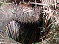
Japanese sergeant Shoichi Yokoi spent 28 years in a self-dug cave in the jungle of Guam, where he hid to avoid capture by US forces in World War II.

See also
 In Spanish: Guam para niños
- 51st state
- Index of Guam-related articles
- Island chain strategy
- Lists of hospitals in the United States#Insular areas
- List of people from Guam
- Outline of Guam
- Voting in Guam
