
Marshall Islands facts for kids
Quick facts for kids
Republic of the Marshall Islands
Aolepān Aorōkin Ṃajeḷ (Marshallese)
|
|
|---|---|
 Seal
|
|
|
Motto: "Jepilpilin ke ejukaan"
"Accomplishment through joint effort" |
|
|
Anthem: "Forever Marshall Islands"
|
|
_(Polynesia_centered).svg) |
|
| Capital and largest city
|
Majuro 7°7′N 171°4′E / 7.117°N 171.067°E |
| Official languages |
|
| Ethnic groups
(2021)
|
|
| Religion
(2021)
|
|
| Demonym(s) | Marshallese |
| Government | Unitary parliamentary republic with an executive presidency |
| Hilda Heine | |
|
• Speaker
|
Brenson S. Wase |
| Legislature | Nitijela |
| Independence
from the United States
|
|
|
• Self-government
|
May 1, 1979 |
|
• Compact of Free Association
|
October 21, 1986 |
| Area | |
|
• Total
|
181.43 km2 (70.05 sq mi) (189th) |
|
• Water (%)
|
n/a (negligible) |
| Population | |
|
• 2021 census
|
42,418 |
|
• Density
|
233/km2 (603.5/sq mi) (47th) |
| GDP (PPP) | 2019 estimate |
|
• Total
|
$215 million |
|
• Per capita
|
$3,789 |
| GDP (nominal) | 2019 estimate |
|
• Total
|
$220 million |
|
• Per capita
|
$3,866 |
| HDI (2022) | high · 102nd |
| Currency | United States dollar (USD) |
| Time zone | UTC+12 (MHT) |
|
• Summer (DST)
|
not observed |
| Date format | MM/DD/YYYY |
| Driving side | right |
| Calling code | +692 |
| ISO 3166 code | MH |
| Internet TLD | .mh |

The Marshall Islands, officially called the Republic of the Marshall Islands, is an island country in the Pacific Ocean. It is located in the Micronesia region, west of the International Date Line and north of the equator.
This country is made up of 29 coral atolls and five main islands. There are also 1,220 other very small islands. These islands are split into two chains: Ratak in the east and Ralik in the west. Most of the country (97.87%) is water, which is the largest water-to-land ratio of any country. The Marshall Islands shares ocean borders with Wake Island to the north and Kiribati to the southeast. It also borders Nauru to the south and the Federated States of Micronesia to the west. The capital and largest city is Majuro, where about half of the country's people live. The Marshall Islands is one of only four countries in the world made mostly of atolls.
Contents
History of the Marshall Islands
Austronesian people first arrived in the Marshall Islands around 2000 BC. They brought important crops like coconuts and breadfruit. They also brought chickens, which helped make the islands a good place to live permanently.
European Contact and German Rule
Spanish explorers visited the islands in the mid-1500s. However, Spanish ships usually sailed further north and avoided the Marshalls. European maps later named the islands after British captain John Marshall. He explored the area in 1788.
In the 1850s, American missionaries and Western businesses started to arrive. German traders became very important in the economy in the 1870s and 1880s. Because of this, the German Empire took control of the Marshalls in 1885, making them a protectorate.
Japanese and American Control
During World War I, in 1914, Japan took over the islands. After the war, the Marshall Islands became part of the Japanese South Seas Mandate. This meant Japan governed them.
During World War II, the United States took control of the islands. After the war, the US managed them as part of the Trust Territory of the Pacific Islands. From 1946 to 1958, the United States conducted 67 nuclear tests at Bikini Atoll and Enewetak Atoll.
Independence and Modern Era
In 1965, the US government created the Congress of the Trust Territory of the Pacific Islands. This was a step towards the islands governing themselves. In May 1979, the United States recognized the Marshall Islands' independence. They got their own constitution and president, Amata Kabua.
The Marshall Islands became fully self-governing through a special agreement with the United States called the Compact of Free Association. Since 1983, the Marshall Islands has been a member of the Pacific Community. In 1991, it also became a member of the United Nations.
Geography and Climate
The Marshall Islands are located on top of ancient underwater volcanoes. They are about halfway between Hawaii and Australia. To the north is the US territory of Wake Island, which the Marshall Islands also claims.
Island Chains and Atolls
The islands and atolls form two main groups: the Ratak (sunrise) and the Ralik (sunset). These two chains run roughly parallel to each other, from northwest to southeast. They cover about 750,000 square miles (1,942,490 km²) of ocean. However, their total land area is only about 70 square miles (181 km²). Each chain has 15 to 18 islands and atolls.
The country has 29 atolls and five separate islands. These are spread across about 180,000 square miles (466,198 km²) of the Pacific. The largest atoll is Kwajalein, with a land area of 6 square miles (15.5 km²). It surrounds a huge lagoon of 655 square miles (1,696 km²).
Twenty-four of the atolls and islands are inhabited. The others are empty because of tough living conditions, lack of rain, or nuclear contamination.
Shark Sanctuary
In October 2011, the government created a huge shark sanctuary. This area covers almost 2 million square kilometers (772,204 sq mi) of ocean. It is the world's largest shark sanctuary. In this protected zone, all shark fishing is banned. Any sharks caught by accident must be released.
Climate Patterns
The climate has a dry season from December to April and a wet season from May to November. Many Pacific typhoons start as tropical storms in the Marshall Islands. They then get stronger as they move west towards the Mariana Islands and the Philippines.
Fresh water usually comes from rainfall. However, the population has grown faster than the water supply. The northern atolls get about 50 inches (127 cm) of rain each year. The southern atolls get about twice that amount. Droughts are common across the islands.
Wildlife of the Marshall Islands
Most birds in the Marshall Islands are either sea birds or birds that migrate. About 70 species of birds live here, including 31 seabirds. 15 of these species build their nests on the islands. Sea birds include the black noddy and the white tern. The only land bird is the house sparrow, which was brought by humans.
Marine Animals
There are about 300 species of fish, and 250 of them are reef fish.
- Turtles: You can find green turtles, hawksbill, Leatherback sea turtles, and Olive ridley sea turtles.
- Sharks: At least 22 types of sharks live here. These include the Blue shark, Silky shark, and Oceanic whitetip shark.
Arthropods
- Scorpions: The dwarf wood scorpion and the common house scorpion live here.
- Spiders: Two types of spiders are found: a scytodes called Dictis striatipes, and Jaluiticola. Jaluiticola is a genus of jumping spiders found only in the Marshall Islands.
- Crabs: Common crabs include hermit crabs and coconut crabs.
People and Culture
Most people living in the Marshall Islands are Marshallese. Marshallese people come from Micronesia. It is believed they moved from Asia to the Marshall Islands thousands of years ago.
The official languages are English and Marshallese. Both languages are spoken widely across the islands.
Almost everyone on the islands practices some religion. About three-quarters of the people belong to either the United Church of Christ – Congregational in the Marshall Islands (UCCCMI) or the Assemblies of God.
Marshallese Culture
The Marshallese were once amazing navigators. They used the stars and special stick-and-shell charts to find their way. While these old skills are not as common now, they are an important part of the islands' history.
Government and Economy
The Marshall Islands is a parliamentary republic with an executive presidency. This means it has a president and a parliament. It is in a special partnership called "free association" with the United States. The US helps with defense and provides financial support. It also gives access to US agencies like the United States Postal Service.
Political Structure
The country's law-making power belongs to the Nitijela, which is their parliament. There is also a Council of Iroij, an advisory group of twelve important chiefs. The President and the Presidential Cabinet make up the executive branch. The President appoints ten ministers with the Nitijela's approval. The country is divided into 24 voting areas, which match the inhabited islands and atolls.
In January 2016, Senator Hilda Heine was chosen by Parliament to be the first female president of the Marshall Islands.
Economic Activities
The islands have few natural resources. They import much more than they export. Farm products include coconuts, tomatoes, melons, taro, and breadfruit. They also raise pigs and chickens. Industries include making copra (dried coconut meat) and craft items. Tuna processing and tourism are also important.
The Marshall Islands plays a key role in global shipping. Many commercial ships register there because of its "flag of convenience" system.
Currency and Cryptocurrency
The country uses the United States dollar as its money. In 2018, the Republic of Marshall Islands made history. They passed the Sovereign Currency Act. This made them the first country to create their own cryptocurrency and make it legal money. This new currency is called the "Sovereign."
Sports in the Marshall Islands
Popular sports in the Marshall Islands include volleyball, basketball (mostly played by men), baseball, and soccer. Water sports are also very popular.
The Marshall Islands has sent athletes to the Olympics since the 2008 Beijing Games. In the 2020 Tokyo Olympics, two swimmers represented the country.
Association Football
The sport of association football (soccer) is quite new to the Marshall Islands. There is a small club league, and Kobeer is the most successful club. A small Football Association exists on the island of Majuro. The Marshall Islands is the only country in the world that does not have a national football team. This means it is the only sovereign country without a record of a national football match.
Baseball and Softball
Softball and baseball are managed by one sports group in the Marshall Islands. The President of this group is Jeimata Nokko Kabua. Both sports are growing quickly, with many Marshallese people supporting the federation. The Marshall Islands won a silver medal in baseball at the Micronesian Games in 2012. They have also won medals in the SPG Games.
Images for kids
-
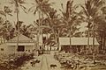
Offices of the Pacific Navigation Co. at Jaluit Atoll in the late 1880s
-

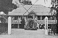
German colonial administration building at Jaluit Atoll in 1886
-
South Seas Government branch office, Jaluit, c. 1932
-
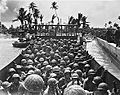
Battle of Kwajalein in 1944
-
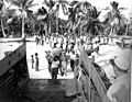
Bikini Islanders being forcibly relocated from Bikini Atoll in March 1946 before the U.S. Operation Crossroads atomic bomb testing commenced
-
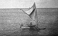
Marshall Islanders sailing, with sails brailed (reefed), c. 1899–1900
-
Battle of Kwajalein in 1944
-
Bikini Islanders departing from Bikini Atoll in March 1948
-
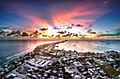
Panorama of Majuro, capital and largest city of Marshall Islands
-
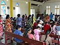
Christians in the Marshall Islands


.jpg)

.jpg)
See also
 In Spanish: Islas Marshall para niños
