
Nauru facts for kids
Quick facts for kids
Republic of Nauru
Repubrikin Naoero (Nauruan)
|
|
|---|---|
 Coat of arms
|
|
|
Motto: "God's will first"
|
|
|
Anthem: Nauru Bwiema
"Nauru, our homeland" |
|
 |
|
| Capital | None (de jure) Yaren (de facto) 0°31′39″S 166°56′06″E / 0.52750°S 166.93500°E |
| Largest city | Denigomodu |
| Official languages |
|
| Demonym(s) | Nauruan |
| Government | Unitary parliamentary republic with an executive presidency under a non-partisan democracy |
| David Adeang | |
| Marcus Stephen | |
| Legislature | Parliament |
| Independence | |
|
• Nauru Independence Act 1967
|
31 January 1968 |
| Area | |
|
• Total
|
21 km2 (8.1 sq mi) (193rd) |
|
• Water (%)
|
0.57 |
| Population | |
|
• 2024 estimate
|
11,919 (227th) |
|
• 2011 census
|
10,084 |
|
• Density
|
480/km2 (1,243.2/sq mi) (25th) |
| GDP (PPP) | 2021 estimate |
|
• Total
|
$132 million (192nd) |
|
• Per capita
|
$9,995 (94th) |
| GDP (nominal) | 2022 estimate |
|
• Total
|
$150 million |
|
• Per capita
|
$10,125 |
| HDI (2022) | medium · 122nd |
| Currency | Australian dollar (AUD) |
| Time zone | UTC+12 |
| Driving side | left |
| Calling code | +674 |
| ISO 3166 code | NR |
| Internet TLD | .nr |

Nauru, also known as the Republic of Nauru, is a small island nation in the Micronesian South Pacific. It is very close to Banaba Island in Kiribati, about 300 kilometers (186 miles) to the east. Nauru is the world's smallest island nation, covering only 21 square kilometers (8.1 square miles). It is also the smallest independent country that is a republic. Nauru is unique because it does not have an official capital city. With about 10,670 people, it is one of the least populated countries in the world.
Nauru sells phosphate (a type of chemical used in fertilizers) to Australia. The two official languages spoken in Nauru are English and Nauruan.
Contents
History of Nauru
Nauru was first settled by Micronesians around 1000 BCE. In the late 1800s, the German Empire took over Nauru and made it a colony.
After World War I, Nauru was managed by Australia, New Zealand, and the United Kingdom under a League of Nations mandate. During World War II, Japanese troops occupied Nauru. The Allied forces, however, did not attack Nauru directly.
After the war, Nauru became a United Nations trusteeship. Nauru finally became an independent country in 1968 and joined the United Nations in 1999.
Geography and Environment

Nauru is an oval-shaped island in the southwestern Pacific Ocean. It is about 42 kilometers (26 miles) south of the Equator. A coral reef surrounds the island. This reef is visible when the tide is low. It has sharp, tall coral formations. Because of the reef, Nauru does not have a large seaport. However, small boats can reach the island through channels in the reef.
Just past the beach, there is a fertile coastal strip. It is about 150 to 300 meters (490 to 980 feet) wide.
Coral cliffs surround the central part of Nauru. The highest point is called the Command Ridge, which is 71 meters (233 feet) above sea level. The only fertile areas are along the narrow coast. Here, coconut palms grow well. Around Buada Lagoon, you can find bananas, pineapples, vegetables, and pandanus trees. There are also native hardwood trees like the tomano tree.
Nauru used to be one of three Pacific islands rich in phosphate rock. The other two were Banaba in Kiribati and Makatea in French Polynesia. However, most of Nauru's phosphate is now gone. Mining the phosphate has left the central plateau looking like a barren landscape. It has jagged limestone peaks up to 15 meters (49 feet) high. Mining has damaged about 80 percent of Nauru's land. It has also harmed the ocean around the island. About 40 percent of sea life has been lost due to dirt and phosphate washing into the water.
There are only about 60 types of vascular plants native to Nauru. None of these plants are found only on Nauru. Coconut farming, mining, and new plant species have greatly disturbed the native plants. There are no native land mammals. However, Nauru has native insects, land crabs, and birds. One special bird is the Nauru Reed Warbler, which is found only there. Other animals like the Polynesian rat, cats, dogs, pigs, and chickens were brought to Nauru by ships.
Nauru has very little natural fresh water. People collect rainwater in rooftop tanks. But most islanders rely on three desalination plants. These plants turn saltwater into fresh water. Nauru's climate is hot and very humid all year. This is because it is close to the equator and the ocean. Nauru gets heavy monsoon rains from November to February. However, it usually does not have cyclones. The amount of rain each year changes a lot. It is affected by the El Niño-Southern Oscillation, which can cause droughts. Temperatures in Nauru range from 26°C (79°F) to 35°C (95°F) during the day. At night, temperatures are between 22°C (72°F) and 34°C (93°F).
As an island, Nauru is at risk from climate change and rising sea levels. Nauru is the seventh most threatened nation by global warming due to potential flooding. Most of Nauru's land is high up. But this area will not be livable until the phosphate mining damage is fixed.
| Climate data for Yaren District, Nauru | |||||||||||||
|---|---|---|---|---|---|---|---|---|---|---|---|---|---|
| Month | Jan | Feb | Mar | Apr | May | Jun | Jul | Aug | Sep | Oct | Nov | Dec | Year |
| Record high °C (°F) | 34 (93) |
37 (99) |
35 (95) |
35 (95) |
32 (90) |
32 (90) |
35 (95) |
33 (91) |
35 (95) |
34 (93) |
36 (97) |
35 (95) |
37 (99) |
| Mean daily maximum °C (°F) | 30 (86) |
30 (86) |
30 (86) |
30 (86) |
30 (86) |
30 (86) |
30 (86) |
30 (86) |
30 (86) |
31 (88) |
31 (88) |
31 (88) |
30 (87) |
| Mean daily minimum °C (°F) | 25 (77) |
25 (77) |
25 (77) |
25 (77) |
25 (77) |
25 (77) |
25 (77) |
25 (77) |
25 (77) |
25 (77) |
25 (77) |
25 (77) |
25 (77) |
| Record low °C (°F) | 21 (70) |
21 (70) |
21 (70) |
21 (70) |
20 (68) |
21 (70) |
20 (68) |
21 (70) |
20 (68) |
21 (70) |
21 (70) |
21 (70) |
20 (68) |
| Average precipitation mm (inches) | 280 (11.0) |
250 (9.8) |
190 (7.5) |
190 (7.5) |
120 (4.7) |
110 (4.3) |
150 (5.9) |
130 (5.1) |
120 (4.7) |
100 (3.9) |
120 (4.7) |
280 (11.0) |
2,080 (81.9) |
| Average precipitation days | 16 | 14 | 13 | 11 | 9 | 9 | 12 | 14 | 11 | 10 | 13 | 15 | 152 |
| Source: [1] | |||||||||||||
How Nauru's Government Works

Nauru is a republic with a parliamentary system of government. This means the country is led by a president and a parliament. The president is both the head of state (the country's main representative) and the head of government (the leader of the government). The president needs the support of the parliament to stay in power.
The parliament has 19 seats, and elections are held every three years. The members of parliament choose the president from among themselves. The president then picks five or six members to form a cabinet, which helps run the country.
Nauru has a Supreme Court. It is led by the Chief Justice. This court makes the final decisions on important issues about the country's laws. Other legal cases can be appealed to the Appellate Court, which has two judges. The parliament cannot change decisions made by the courts.
Areas of Nauru
Nauru is divided into 14 administrative districts. These districts are grouped into eight areas for elections.

| Nr. | District | Former Name | Area (ha) |
Population (2005) |
No. of villages |
Density persons / ha |
|---|---|---|---|---|---|---|
| 1 | Aiwo | Aiue | 100 | 1,092 | 8 | 10.9 |
| 2 | Anabar | Anabar | 143 | 502 | 15 | 3.5 |
| 3 | Anetan | Añetañ | 100 | 516 | 12 | 5.2 |
| 4 | Anibare | Anybody | 314 | 160 | 17 | 0.5 |
| 5 | Baiti | Beidi | 123 | 572 | 15 | 4.7 |
| 6 | Boe | Boi | 66 | 795 | 4 | 12.0 |
| 7 | Buada | Buada | 266 | 716 | 14 | 2.7 |
| 8 | Denigomodu | Denikomotu | 118 | 2,827 | 17 | 24.0 |
| 9 | Ewa | Eoa | 117 | 318 | 12 | 2.7 |
| 10 | Ijuw | Ijub | 112 | 303 | 13 | 2.7 |
| 11 | Meneng | Meneñ | 288 | 1,830 | 18 | 6.4 |
| 12 | Nibok | Ennibeck | 136 | 432 | 11 | 3.2 |
| 13 | Uaboe | Ueboi | 97 | 335 | 6 | 3.5 |
| 14 | Yaren | Moqua | 150 | 820 | 7 | 5.5 |
| Nauru | Naoero | 2,130 | 11,218 | 169 | 5.3 |
Nauru's Economy

Nauru's economy was strongest in the 1970s, with its highest GDP (the total value of goods and services produced) in 1981. This was mostly due to phosphate mining. However, mining began to decline in the early 1980s.
Nauru has few other natural resources, so most things people need are brought in from other countries. There are no personal taxes in Nauru.
People and Culture

Nauru is one of the most densely populated countries in the South Pacific. It has also adopted many Western ways of life.
The official languages are Nauruan and English. Nauruan is a unique Micronesian language. About 96% of Nauruans speak it at home. English is widely used for government and business.
.jpg)
The main religion on the island is Christianity.
Food and Farming

In the past, Nauruans grew much of their own food in home gardens. They practiced subsistence farming, meaning they grew food mainly for themselves. Common plants included coconuts, breadfruit, bananas, pandanus, papaya, and guavas.
The soil on the "Topside" (the raised phosphate plateau) was very rich and good for growing crops. However, most Nauruans now live on the coastal ring, which has not been mined. The soil there is very poor, shallow, and rocky. In 2011, only 13% of homes had a garden or grew crops. Most of Nauru's original soil is gone because of phosphate mining. This means people must import soil if they want to grow things.
Studies show that the loss of plants due to mining has affected Nauruans' connection to their land. Plants are a big part of their culture and have many uses.
Today, almost all food for Nauru residents must be imported. This is because 90% of the land that could be farmed is gone due to phosphate mining. People now mostly eat processed foods like rice and sugar. This reliance on imported, processed foods has greatly affected the health of Nauru's citizens.
Music and Arts

Nauruan folk songs existed in the 1970s, with "Oh Bwio Eben Bwio" being a well-known one. While modern influences are changing traditional culture, music and dance remain popular. Rhythmic singing and traditional dances are often performed at celebrations.
A historical Nauruan dance, called the "fish dance," was recorded in old photographs. Today, known dances include the frigate bird dance and the dogoropa.
Nauru's national anthem is "Nauru Bwiema" ("Song of Nauru"). Margaret Hendrie wrote the words, and Laurence Henry Hicks composed the music.
Sports in Nauru

Australian rules football is the most popular sport in Nauru. It is considered the country's national team sport. There is an Australian rules football league with eight teams. Nauru's national teams often rank among the top eight in the world.
Other popular sports include weightlifting (a national pastime), volleyball, netball, fishing, and tennis. Nauru competes in the Commonwealth Games and has sent athletes to the Summer Olympic Games for weightlifting and judo.
Nauru's national basketball team played in the 1969 Pacific Games. They won against the teams from Solomon Islands and Fiji.
Rugby union in Nauru is also growing in popularity. The Nauru national rugby sevens team played its first international game at the 2015 Pacific Games. They also competed in the 2015 Oceania Sevens Championship in New Zealand.
Soccer in Nauru is a smaller sport. It has not been very active because Australian rules football and rugby are more popular. However, a Nauru national soccer team was being formed in 2024.
Nauru's Flag
The flag of Nauru (Nauruan: anidenin Naoero) was first raised when Nauru became independent on January 31, 1968. The flag was chosen in a local design competition. Its design shows Nauru's location on Earth.
The flag has a narrow gold stripe that is one-twelfth of the flag's length. This stripe represents the Equator. The stripe and the star show that the island is in the Pacific Ocean, just one degree south of the Equator. The blue flag is split into two equal parts. This represents an old story that the first people came to Earth from two large rocks.
Nauru itself is shown by a white 12-pointed star. The twelve points stand for the island's twelve original tribes.
The blue color represents the Pacific Ocean. The white color of the star stands for phosphate. Phosphate used to be a very important natural resource for the country.
An employee of an Australian flag company created the flag. It was officially adopted on January 31, 1968. Unlike some flags of other Pacific nations, Nauru's flag has not caused much disagreement.
Images for kids
-
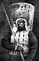
Photo of a Nauruan warrior during the Nauruan Civil War around 1880
-
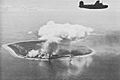
US Army Air Force bombing the Japanese airstrip on Nauru, 1943.
-
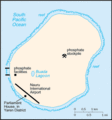
Map of Nauru
-
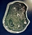
A satellite image of Nauru, 2002
-
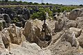
Limestone pinnacles remain after phosphate mining at the site of one of Nauru's secondary mines
-
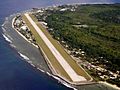
View of Nauru International Airport


.jpg)

See also
 In Spanish: Nauru para niños
